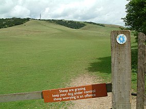
The South Downs Way is a long distance footpath and bridleway running along the South Downs in southern England. It is one of 16 National Trails in England and Wales. The trail runs for 160 km (100 mi) from Winchester in Hampshire to Eastbourne in East Sussex, with about 4,150 m (13,620 ft) of ascent and descent.

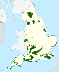
The South Downs are a range of chalk hills in the south-eastern coastal counties of England that extends for about 260 sq mi (670 km2) across the south-eastern coastal counties of England from the Itchen valley of Hampshire in the west to Beachy Head, in the Eastbourne Downland Estate, East Sussex, in the east. The Downs are bounded on the northern side by a steep escarpment, from whose crest there are extensive views northwards across the Weald. The South Downs National Park forms a much larger area than the chalk range of the South Downs, and includes large parts of the Weald.
East Hampshire is a local government district in Hampshire, England. Its council is based in the town of Petersfield, although the largest town is Alton. The district also contains the town of Bordon along with many villages and surrounding rural areas.

The South Downs National Park is England's newest national park, designated on 31 March 2010. The park, covering an area of 1,627 square kilometres (628 sq mi) in southern England, stretches for 140 kilometres (87 mi) from Winchester in the west to Eastbourne in the east through the counties of Hampshire, West Sussex and East Sussex. The national park covers the chalk hills of the South Downs and a substantial part of a separate physiographic region, the western Weald, with its heavily wooded sandstone and clay hills and vales. The South Downs Way spans the entire length of the park and is the only National Trail that lies wholly within a national park.

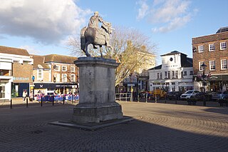
Petersfield is a market town and civil parish in the East Hampshire district of Hampshire, England. It is 15 miles (24 km) north of Portsmouth. The town has its own railway station on the Portsmouth Direct line, the mainline rail link connecting Portsmouth and London. Situated below the northern slopes of the South Downs, Petersfield lies wholly within the South Downs National Park.

The A272 is a road in southeast England. It follows an approximate east–west route from near Heathfield, East Sussex to the city of Winchester, Hampshire.

The North Wessex Downs are an area of chalk downland landscapes located in the English counties of Berkshire, Hampshire, Oxfordshire and Wiltshire. The North Wessex Downs has been designated as a National Landscape since 1972.

The Kent Downs is an Area of Outstanding Natural Beauty (AONB) in Kent, England. They are the eastern half of the North Downs and stretch from the London/Surrey borders to the White Cliffs of Dover, including a small section of the London Borough of Bromley. The AONB also includes the Greensand Ridge, a prominent sandstone escarpment which lies south of the chalk escarpment of the North Downs.

The Itchen Way is a 31.80-mile (51.18 km) long-distance footpath following the River Itchen in Hampshire, England, from its source near Hinton Ampner House to its mouth at Woolston. The walk finishes at Sholing railway station. The route has been promoted by the Eastleigh Group of the Ramblers with grant aid from Hampshire County Council and Eastleigh Borough Council. The route was altered and improved in 2008.

The High Weald National Landscape is in south-east England. Covering an area of 1,450 square kilometres (560 sq mi), it takes up parts of Kent, Surrey, East Sussex, and West Sussex. It is the fourth largest Area of Outstanding Natural Beauty (AONB) in England and Wales. It has an attractive landscape with a mosaic of small farms and woodlands, historic parks, sunken lanes and ridge-top villages.
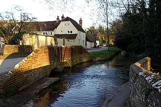
Buriton is a village and civil parish in the East Hampshire district of Hampshire, England. It is located 2 miles (3.3 km) south of Petersfield.

East Hampshire is a constituency represented in the House of Commons of the UK Parliament since 2010 by Damian Hinds of the Conservative Party.
The following are lists of recreational walks in Hampshire, England:

The Greensand Ridge, also known as the Wealden Greensand, is an extensive, prominent, often wooded, mixed greensand/sandstone escarpment in south-east England. Forming part of the Weald, a former dense forest in Sussex, Surrey and Kent, it runs to and from the East Sussex coast, wrapping around the High Weald and Low Weald. It reaches its highest elevation, 294 metres (965 ft), at Leith Hill in Surrey—the second highest point in south-east England, while another hill in its range, Blackdown, is the highest point in Sussex at 280 metres (919 ft). The eastern end of the ridge forms the northern boundary of Romney Marsh.
Warnford is a village and civil parish in the City of Winchester district of Hampshire, England. The parish covers 1283 hectares. The village lies on the A32 in the upper valley of the River Meon between West Meon and Exton. The population in 2019 was estimated at 220. The village is rural in character, with most of the buildings along River Lane, Lippen Lane and Hayden Lane.

Sussex is a historic county and cultural region in the south of England corresponding roughly in area to the ancient Kingdom of Sussex. It is bounded on the north by Surrey, north-east by Kent, south by the English Channel, and west by Hampshire, and is divided for local government into West Sussex and East Sussex and the city of Brighton and Hove. The city of Brighton & Hove was created a unitary authority in 1997, and was granted City status in 2000. Until then Chichester had been Sussex's only city. By convention, Chichester is Sussex's capital city and Lewes is Sussex's county town.
The western Weald is an area of undulating countryside in Hampshire and West Sussex containing a mixture of woodland and heathland areas.

Sussex Downs Area of Outstanding Natural Beauty in England was designated in 1966. The designation was revoked in March 2010, together with the neighbouring East Hampshire AONB, upon the establishment of the South Downs National Park.

The Chichester to Silchester Way is a Roman Road between Chichester in South-East England, which as Noviomagus was capital of the Regni, and Silchester or Calleva Atrebatum, capital of the Atrebates. The road had been entirely lost and forgotten, leaving no Saxon place names as clues to its existence, until its chance discovery through aerial photography in 1949. Only 6 kilometres (3.7 mi) of the 62 kilometres (39 mi) long road remain in use.

The Hampshire Downs form a large area of downland in central southern England, mainly in the county of Hampshire but with parts in Berkshire and Wiltshire. They are part of a belt of chalk downland that extends from the South Downs in the southeast, north to the Berkshire and Marlborough Downs, and west to the Dorset Downs.