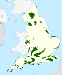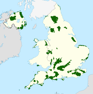
An Area of Outstanding Natural Beauty is one of 46 areas of countryside in England, Wales, or Northern Ireland that has been designated for conservation due to its significant landscape value. Since 2023, the areas in England and Wales have also adopted the name National Landscapes.

Downland, chalkland, chalk downs or just downs are areas of open chalk hills, such as the North Downs. This term is used to describe the characteristic landscape in southern England where chalk is exposed at the surface. The name "downs" is derived from the Celtic word "dun", meaning "fort" or "fastness", though the original meaning would have been "hill", as early forts were commonly hillforts - compare Germanic "burg" (fort) and "berg" (mountain).

The South Downs are a range of chalk hills in the south-eastern coastal counties of England that extends for about 260 sq mi (670 km2) across the south-eastern coastal counties of England from the Itchen valley of Hampshire in the west to Beachy Head, in the Eastbourne Downland Estate, East Sussex, in the east. The Downs are bounded on the northern side by a steep escarpment, from whose crest there are extensive views northwards across the Weald. The South Downs National Park forms a much larger area than the chalk range of the South Downs, and includes large parts of the Weald.

The North Downs are a ridge of chalk hills in south east England that stretch from Farnham in Surrey to the White Cliffs of Dover in Kent. Much of the North Downs comprises two Areas of Outstanding Natural Beauty (AONBs): the Surrey Hills and the Kent Downs. The North Downs Way National Trail runs along the North Downs from Farnham to Dover.

Chichester is a local government district in West Sussex, England. It is named after the city of Chichester, which is its largest settlement and where the council is based. The district includes the towns of Midhurst, Petworth and Selsey and surrounding rural areas, including many villages. The district includes part of the South Downs National Park, and Chichester Harbour is a designated Area of Outstanding Natural Beauty. At the 2021 census the district had a population of 124,531.

The South Downs National Park is England's newest national park, designated on 31 March 2010. The park, covering an area of 1,627 square kilometres (628 sq mi) in southern England, stretches for 140 kilometres (87 mi) from Winchester in the west to Eastbourne in the east through the counties of Hampshire, West Sussex and East Sussex. The national park covers the chalk hills of the South Downs and a substantial part of a separate physiographic region, the western Weald, with its heavily wooded sandstone and clay hills and vales. The South Downs Way spans the entire length of the park and is the only National Trail that lies wholly within a national park.

The North Wessex Downs are an area of chalk downland landscapes located in the English counties of Berkshire, Hampshire, Oxfordshire and Wiltshire. The North Wessex Downs has been designated as a National Landscape since 1972.
Cranborne Chase is an area of central southern England, straddling the counties Dorset, Hampshire and Wiltshire. It is part of the Cranborne Chase and West Wiltshire Downs Area of Outstanding Natural Beauty (AONB).

The Kent Downs is an Area of Outstanding Natural Beauty (AONB) in Kent, England. They are the eastern half of the North Downs and stretch from the London/Surrey borders to the White Cliffs of Dover, including a small section of the London Borough of Bromley. The AONB also includes the Greensand Ridge, a prominent sandstone escarpment which lies south of the chalk escarpment of the North Downs.

The High Weald National Landscape is in south-east England. Covering an area of 1,450 square kilometres (560 sq mi), it takes up parts of Kent, Surrey, East Sussex, and West Sussex. It is the fourth largest Area of Outstanding Natural Beauty (AONB) in England and Wales. It has an attractive landscape with a mosaic of small farms and woodlands, historic parks, sunken lanes and ridge-top villages.
Queen Elizabeth Country Park is a large country park situated on the South Downs in southern England. It is located on the A3 road three miles south of Petersfield, Hampshire and lies within the South Downs National Park.

Stanmer Park is a large public park immediately to the west of the University of Sussex, and to the north-east of the city of Brighton in the county of East Sussex, England, UK. It is a Local Nature Reserve and English Heritage, under the National Heritage Act 1983, has registered the park on the Register of Parks and Gardens of Special Historic Interest in England at Grade II level.
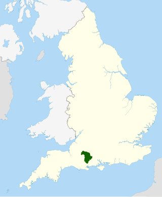
Cranborne Chase and West Wiltshire Downs, marketed as the Cranborne Chase National Landscape, is an Area of Outstanding Natural Beauty (AONB) covering 379 square miles (980 km2) of Dorset, Hampshire, Somerset and Wiltshire. It is the sixth largest AONB in England.
East Hampshire Area of Outstanding Natural Beauty (AONB) in England was designated in 1962. The designation was revoked in March 2010, together with the neighbouring Sussex Downs AONB, upon the establishment of the South Downs National Park. The southern part of the area is mainly rolling chalk downland used for farming that is a westward extension of the Sussex Downs. The north and east includes steep wooded hills and heathland.

The South Hampshire Coast was an Area of Outstanding Natural Beauty (AONB) in Hampshire, England, UK that was subsumed into the New Forest National Park when it was established on 1 April 2005. It lies between the New Forest and the west shore of the Solent.

The Sussex Border Path is a long-distance footpath around the borders of Sussex, a historic county and former medieval kingdom in southern England. The main path is 150 miles (240 km) long and stays close to Sussex's borders with Hampshire, Surrey and Kent, connecting Thorney Island to Rye. There is also an additional 33-mile (53 km) spur known as the Mid Sussex Link, which links East Grinstead with Fishersgate and Mile Oak on the western boundary of the city of Brighton and Hove.

Sussex is a historic county and cultural region in the south of England corresponding roughly in area to the ancient Kingdom of Sussex. It is bounded on the north by Surrey, north-east by Kent, south by the English Channel, and west by Hampshire, and is divided for local government into West Sussex and East Sussex and the city of Brighton and Hove. The city of Brighton & Hove was created a unitary authority in 1997, and was granted City status in 2000. Until then Chichester had been Sussex's only city. By convention, Chichester is Sussex's capital city and Lewes is Sussex's county town.
The western Weald is an area of undulating countryside in Hampshire and West Sussex containing a mixture of woodland and heathland areas.
Sussex Downs Conservation Board was an English local government organisation based in East and West Sussex to promote and manage the Sussex Downs Area of Outstanding Natural Beauty. In March 2010 the status of the AONB was revoked and the management of the Sussex Downs AONB was merged with the East Hampshire AONB under the South Downs Joint Committee pending the formation of a national park authority. On the 1 April 2011 the South Downs National Park was established under the South Downs National Park Authority.

The Hampshire Downs form a large area of downland in central southern England, mainly in the county of Hampshire but with parts in Berkshire and Wiltshire. They are part of a belt of chalk downland that extends from the South Downs in the southeast, north to the Berkshire and Marlborough Downs, and west to the Dorset Downs.