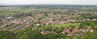
Frodsham is a market town, civil parish, and electoral ward in the unitary authority of Cheshire West and Chester and the ceremonial county of Cheshire, England. Its population in 2021 was 9,300. It is 16 miles (26 km) south of Liverpool and 28 miles (45 km) southwest of Manchester. The River Weaver runs to its northeast and on the west it overlooks the estuary of the River Mersey. The A56 road and the Chester–Manchester railway line pass through the town, and the M56 motorway passes to the northwest.

Kelsall is a village and civil parish in the unitary authority of Cheshire West and Chester and the ceremonial county of Cheshire, England. It is located around 8 miles (13 km) east of Chester, 8 miles (13 km) west of Northwich, and 4 miles (6 km) north west of Tarporley. The village is situated on Kelsall Hill, a part of the Mid-Cheshire Ridge, the broken line of sandstone hills that divide the west Cheshire Plain from its eastern counterpart. The ridge includes other hills including Peckforton, Beeston, Frodsham, and Helsby.

Beeston Castle is a former Royal castle in Beeston, Cheshire, England, perched on a rocky sandstone crag 350 feet (107 m) above the Cheshire Plain. It was built in the 1220s by Ranulf de Blondeville, 6th Earl of Chester (1170–1232), on his return from the Crusades. In 1237, Henry III took over the ownership of Beeston, and it was kept in good repair until the 16th century, when it was considered to be of no further military use, although it was pressed into service again in 1643, during the English Civil War. The castle was slighted in 1646, in accordance with Cromwell's destruction order, to prevent its further use as a bastion. During the 18th century, parts of the site were used as a quarry.
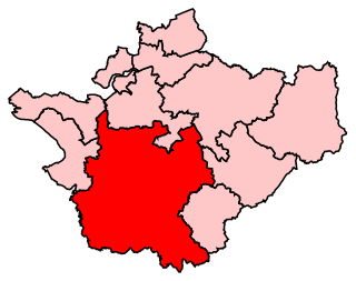
Eddisbury is a constituency in Cheshire represented in the House of Commons of the UK Parliament since 2019 by Edward Timpson, a Conservative.

Weaver Vale is a constituency in Cheshire represented in the House of Commons of the UK Parliament since 2017 by Mike Amesbury, a member of the Labour Party.
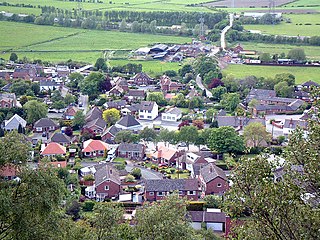
Helsby is a village, civil parish and electoral ward in the unitary authority of Cheshire West and Chester and the ceremonial county of Cheshire, England. Overlooking the Mersey estuary, it is approximately 9 miles (14 km) north east of Chester and 2.5 miles (4 km) south west of Frodsham.

Bickerton is a village and civil parish in the unitary authority of Cheshire East and the ceremonial county of Cheshire, England, about 8 miles (13 km) north of Whitchurch in Shropshire. The parish also includes the small settlement of Gallantry Bank, with a total population of over 200. The two Bickerton Hills also lie partly within the civil parish.

Bulkeley is a village and former civil parish, now in the parish of Bulkeley and Ridley, in the unitary authority area of Cheshire East and the ceremonial county of Cheshire, England. The village is on the A534 road, 9 miles (14 km) west of Nantwich. In the 2011 census it had a population of 239.
Bickerton Hill refers to two low red sandstone hills that form the southern end of the Mid Cheshire Ridge in Cheshire, north-west England. The high point, Raw Head, lies on the northerly hill and has an elevation of 227 metres. Parts of the southerly hill are also known as Larkton Hill.

The Sandstone Trail is a 55-kilometre (34 mi) long-distance walkers' path, following sandstone ridges running north–south from Frodsham in central Cheshire to Whitchurch just over the Shropshire border. The path was created in 1974 and extended in the 1990s. Much of the route follows the Mid Cheshire Ridge but in places the trail also passes through the Cheshire Plain, including farmland, woodland and canal towpaths.

The Peckforton Hills are a sandstone ridge running broadly northeast–southwest in the west of the English county of Cheshire. They form a significant part of the longer Mid Cheshire Ridge which extends southwards from Frodsham towards Malpas.

Peckforton is a scattered settlement and civil parish in the unitary authority of Cheshire East and the ceremonial county of Cheshire, England. The settlement is located 6.5 miles (10.5 km) to the north east of Malpas and 7.5 miles (12.1 km) to the west of Nantwich. The civil parish covers 1,754 acres (710 ha), with an estimated total population of 150 in 2006. The area is predominantly agricultural. Nearby villages include Bulkeley to the south, Beeston to the north, Higher Burwardsley to the west, Spurstow to the east and Bunbury to the north east.

Ridley is a former civil parish, now in the parish of Bulkeley and Ridley, in the unitary authority area of Cheshire East and the ceremonial county of Cheshire, England, which lies to the north east of Malpas and to the west of Nantwich. The parish is largely rural with scattered farms and buildings and no significant settlements. In 2001, the population was 120. Nearby villages include Bulkeley, Bunbury, Faddiley, Peckforton and Spurstow. At the 2011 Census the population had fallen less than 100. Details are included in the civil parish of Peckforton.
This is a list of places of interest in Cheshire, England. See List of places in Cheshire for a list of settlements in the county.

Woodhouse hill fort is an Iron Age hillfort between Frodsham and Helsby in Cheshire, England. It lies at the northern end of the Mid Cheshire Ridge. Woodhouse Hill has steep cliffs on the western sides, providing a natural defence. It is defended by a rampart to the north and east where the ground slopes more gently. Excavations in 1951 showed that the rampart was originally 4m high and revetted with stone on both sides. A number of small rounded stones, believed to be slingstones, have been found on the site. The hill fort is protected as a Scheduled Ancient Monument.

The Sherwood Sandstone Group is a Triassic lithostratigraphic group which is widespread in Britain, especially in the English Midlands. The name is derived from Sherwood Forest in Nottinghamshire which is underlain by rocks of this age. It has economic importance as the reservoir of the Morecambe Bay gas field, the second largest gas field in the UK.
The county of Cheshire, England, has many buildings that have been listed.


