A drumlin, from the Irish word droimnín, first recorded in 1833, in the classical sense is an elongated hill in the shape of an inverted spoon or half-buried egg formed by glacial ice acting on underlying unconsolidated till or ground moraine. Assemblages of drumlins are referred to as fields or swarms; they can create a landscape which is often described as having a 'basket of eggs topography'.

Glaciology is the scientific study of glaciers, or, more generally, ice and natural phenomena that involve ice.

A jökulhlaup is a type of glacial outburst flood. It is an Icelandic term that has been adopted in glaciological terminology in many languages. It originally referred to the well-known subglacial outburst floods from Vatnajökull, Iceland, which are triggered by geothermal heating and occasionally by a volcanic subglacial eruption, but it is now used to describe any large and abrupt release of water from a subglacial or proglacial lake/reservoir.

Hydraulic head or piezometric head is a specific measurement of liquid pressure above a vertical datum.
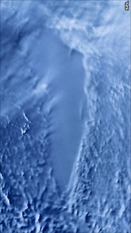
A subglacial lake is a lake that is found under a glacier, typically beneath an ice cap or ice sheet. Subglacial lakes form at the boundary between ice and the underlying bedrock, where gravitational pressure decreases the pressure melting point of ice. Over time, the overlying ice gradually melts at a rate of a few millimeters per year. Meltwater flows from regions of high to low hydraulic pressure under the ice and pools, creating a body of liquid water that can be isolated from the external environment for millions of years.

A subglacial volcano, also known as a glaciovolcano, is a volcanic form produced by subglacial eruptions or eruptions beneath the surface of a glacier or ice sheet which is then melted into a lake by the rising lava. Today they are most common in Iceland and Antarctica; older formations of this type are found also in British Columbia and Yukon Territory, Canada.

A tunnel valley is a U-shaped valley originally cut under the glacial ice near the margin of continental ice sheets such as that now covering Antarctica and formerly covering portions of all continents during past glacial ages. They can be as long as 100 km (62 mi), 4 km (2.5 mi) wide, and 400 m (1,300 ft) deep.
Radioglaciology is the study of glaciers, ice sheets, ice caps and icy moons using ice penetrating radar. It employs a geophysical method similar to ground-penetrating radar and typically operates at frequencies in the MF, HF, VHF and UHF portions of the radio spectrum. This technique is also commonly referred to as "Ice Penetrating Radar (IPR)" or "Radio Echo Sounding (RES)".
Subglacial eruptions, those of ice-covered volcanoes, result in the interaction of magma with ice and snow, leading to meltwater formation, jökulhlaups, and lahars. Flooding associated with meltwater is a significant hazard in some volcanic areas, including Iceland, Alaska, and parts of the Andes. Jökulhlaups have been identified as the most frequently occurring volcanic hazard in Iceland, with major events where peak discharges of meltwater can reach 10,000 – 100,000 m3/s occurring when there are large eruptions beneath glaciers. It is important to explore volcano-ice interactions to improve the effectiveness of monitoring these events and to undertake hazard assessments. This is particularly relevant given that subglacial eruptions have demonstrated their ability to cause widespread impact, with the ash cloud associated with Iceland's Eyjafjallajökull eruption in 2010 resulting in significant impacts to aviation across Europe.
Fluvioglacial landforms or glaciofluvial landforms are those that result from the associated erosion and deposition of sediments caused by glacial meltwater. Glaciers contain suspended sediment loads, much of which is initially picked up from the underlying landmass. Landforms are shaped by glacial erosion through processes such as glacial quarrying, abrasion, and meltwater. Glacial meltwater contributes to the erosion of bedrock through both mechanical and chemical processes. Fluvio-glacial processes can occur on the surface and within the glacier. The deposits that happen within the glacier are revealed after the entire glacier melts or partially retreats. Fluvio-glacial landforms and erosional surfaces include: outwash plains, kames, kame terraces, kettle holes, eskers, varves, and proglacial lakes.

Ice sheet dynamics describe the motion within large bodies of ice such as those currently on Greenland and Antarctica. Ice motion is dominated by the movement of glaciers, whose gravity-driven activity is controlled by two main variable factors: the temperature and the strength of their bases. A number of processes alter these two factors, resulting in cyclic surges of activity interspersed with longer periods of inactivity, on both hourly and centennial time scales. Ice-sheet dynamics are of interest in modelling future sea level rise.

Overdeepening is a characteristic of basins and valleys eroded by glaciers. An overdeepened valley profile is often eroded to depths which are hundreds of metres below the lowest continuous surface line along a valley or watercourse. This phenomenon is observed under modern day glaciers, in salt-water fjords and fresh-water lakes remaining after glaciers melt, as well as in tunnel valleys which are partially or totally filled with sediment. When the channel produced by a glacier is filled with debris, the subsurface geomorphic structure is found to be erosionally cut into bedrock and subsequently filled by sediments. These overdeepened cuts into bedrock structures can reach a depth of several hundred metres below the valley floor.
Subglacial streams are conduits of glacial meltwater that flow at the base of glaciers and ice caps. Meltwater from the glacial surface travels downward throughout the glacier, forming an englacial drainage system consisting of a network of passages that eventually reach the bedrock below, where they form subglacial streams. Subglacial streams form a system of tunnels and interlinked cavities and conduits, with water flowing under extreme pressures from the ice above; as a result, flow direction is determined by the pressure gradient from the ice and the topography of the bed rather than gravity. Subglacial streams form a dynamic system that is responsive to changing conditions, and the system can change significantly in response to seasonal variation in meltwater and temperature. Water from subglacial streams is routed towards the glacial terminus, where it exits the glacier. Discharge from subglacial streams can have a significant impact on local, and in some cases global, environmental and geological conditions. Sediments, nutrients, and organic matter contained in the meltwater can all influence downstream and marine conditions. Climate change may have a significant impact on subglacial stream systems, increasing the volume of meltwater entering subglacial drainage systems and influencing their hydrology.

A glacier stream is a channelized area that is formed by a glacier in which liquid water accumulates and flows. Glacial streams are also commonly referred to as "glacier stream" or/and "glacial meltwater stream". The movement of the water is influenced and directed by gravity and the melting of ice. The melting of ice forms different types of glacial streams such as supraglacial, englacial, subglacial and proglacial streams. Water enters supraglacial streams that sit at the top of the glacier via filtering through snow in the accumulation zone and forming slush pools at the FIRN zone. The water accumulates on top of the glacier in supraglacial lakes and into supraglacial stream channels. The meltwater then flows through various different streams either entering inside the glacier into englacial channels or under the glacier into subglacial channels. Finally, the water leaves the glacier through proglacial streams or lakes. Proglacial streams do not only act as the terminus point but can also receive meltwater. Glacial streams can play a significant role in energy exchange and in the transport of meltwater and sediment.
Hans Röthlisberger was a Swiss earth scientist and glaciologist best known for his work on glacier hazards and their prevention, glacier geophysics and subglacial hydrology.
Almut Iken was a German glaciologist most noted for her work on the role of basal meltwater in subglacial motion. In 2011, she was awarded the Seligman Crystal award from the International Glaciological Society and remains the only female recipient.
A meltwater channel is a channel cut into ice, bedrock or unconsolidated deposits by the flow of water derived from the melting of a glacier or ice-sheet. The channel may form on the surface of, within, beneath, along the margins of or downstream from the ice mass. Accordingly it would be referred to as supraglacial, englacial, subglacial, lateral or proglacial.

Gjálp is a hyaloclastite ridge (tindar) in Iceland under the Vatnajökull glacier shield. It originated in an eruption series in 1996 and is probably part of the Grímsvötn volcanic system, though not all the scientists involved are of this opinion.
An ice shelf basal channel is a type of subglacial meltwater channel that forms on the underside of floating ice shelves connected to ice sheets. Basal channels are generally rounded cavities which form parallel to ice sheet flow. These channels are found mainly around the Greenland and Antarctic ice sheets in places with relatively warm ocean water. West Antarctica in particular has the highest density of basal channels in the world. Basal channels can be tens of kilometers long, kilometers wide, and incise hundreds of meters up into an ice shelf. These channels can evolve and grow just as rapidly as ice shelves can, with some channels having incision rates approaching 22 meters per year. Basal channels are categorized based on what mechanisms created them and where they formed.
In theoretical glaciology and continuum mechanics, the Glen–Nye flow law, also referred to as Glen's flow law, is an empirically derived constitutive relation widely used as a model for the rheology of glacial ice. The Glen–Nye flow law treats ice as a purely viscous, incompressible, isotropic, non-Newtonian fluid, with a viscosity determined by a power law relation between strain rate and stress:


