
Emsworth is a town in the Borough of Havant in the county of Hampshire, on the south coast of England near the border with West Sussex. It lies at the north end of an arm of Chichester Harbour, a large and shallow inlet from the English Channel, and is equidistant between Portsmouth and Chichester.

Hampshire is a ceremonial county in South East England. It is bordered by Berkshire to the north, Surrey and West Sussex to the east, the Isle of Wight across the Solent to the south, Dorset to the west, and Wiltshire to the north-west. The cities of Southampton and Portsmouth are the largest settlements, and the county town is the city of Winchester.

Waterlooville is a town in the Borough of Havant in Hampshire, England, approximately 6 miles (9.7 km) north northeast of Portsmouth. It is the largest town in the borough. The town had a population of 64,350 in the 2011 Census. It is surrounded by Purbrook, Blendworth, Cowplain, Lovedean, Clanfield, Catherington, Crookhorn, Denmead, Hambledon, Horndean and Widley. It forms part of the South Hampshire conurbation. The town formed around the old A3 London to Portsmouth road.

Havant is a town in the south-east corner of Hampshire, England, between Portsmouth and Chichester. Its borough comprises the town (45,826), the resort of Hayling Island, the town of Waterlooville, and the town of Emsworth. Housing and population more than doubled in the 20 years following World War II, a period of major conversion of land from agriculture and woodland to housing across the region following the incendiary bombing of Portsmouth and the Blitz.

Hampshire County Council (HCC) is the upper-tier local authority for the non-metropolitan county of Hampshire in England. The council was created in 1889. The county council provides county-level services to eleven of the thirteen districts geographically located within the ceremonial county of Hampshire. The county council acts as the upper tier of local government to approximately 1.4 million people. It is one of 21 county councils in England.

The South Downs are a range of chalk hills in the south-eastern coastal counties of England that extends for about 260 sq mi (670 km2) across the south-eastern coastal counties of England from the Itchen valley of Hampshire in the west to Beachy Head, in the Eastbourne Downland Estate, East Sussex, in the east. The Downs are bounded on the northern side by a steep escarpment, from whose crest there are extensive views northwards across the Weald. The South Downs National Park forms a much larger area than the chalk range of the South Downs, and includes large parts of the Weald.
East Hampshire is a local government district in Hampshire, England. Its council is based in the town of Petersfield, although the largest town is Alton. The district also contains the town of Bordon along with many villages and surrounding rural areas.
HSDC is a Further education college located in Waterlooville, Hampshire, England. The college was formed on 1 August 2017 following a merger of South Downs College and Havant Sixth Form College.

South Hampshire is a term used mainly to refer to the conurbation formed by the city of Portsmouth, city of Southampton and the non-metropolitan boroughs of Gosport, Fareham, Havant and Eastleigh in southern Hampshire, South East England. The area was estimated to have a population of over 1.5 million in 2013. It is the most populated part of South East England excluding London. The area is sometimes referred to as Solent City particularly in relation to local devolution, but the term is controversial.

Portsmouth Water is the utility company responsible for water supply and distribution in the City of Portsmouth, part of East Hampshire and part of West Sussex. Places served include Gosport, Fareham, Portsmouth, Havant, Chichester, and Bognor Regis. The company is a private limited company with company number 2536455. It was acquired by Ancala in March 2018.

Sussex is a historic county and cultural region in the south of England corresponding roughly in area to the ancient Kingdom of Sussex. It is bounded on the north by Surrey, north-east by Kent, south by the English Channel, and west by Hampshire, and is divided for local government into West Sussex and East Sussex and the city of Brighton and Hove. The city of Brighton & Hove was created a unitary authority in 1997, and was granted City status in 2000. Until then Chichester had been Sussex's only city. By convention, Chichester is Sussex's capital city and Lewes is Sussex's county town.

The Hampshire Basin is a geological basin of Palaeogene age in southern England, underlying parts of Hampshire, the Isle of Wight, Dorset, and Sussex. Like the London Basin to the northeast, it is filled with sands and clays of Paleocene and younger ages and it is surrounded by a broken rim of chalk hills of Cretaceous age.
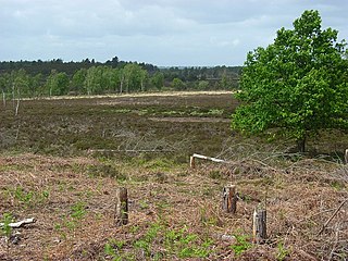
Woolmer Forest is a 1,298.5-hectare (3,209-acre) biological Site of Special Scientific Interest south of Bordon in Hampshire and West Sussex. It is also a Special Area of Conservation and part of the Wealden Heaths Phase II Special Protection Area. Two areas are Nature Conservation Review sites, Grade I.

The Hampshire Downs form a large area of downland in central southern England, mainly in the county of Hampshire but with parts in Berkshire and Wiltshire. They are part of a belt of chalk downland that extends from the South Downs in the southeast, north to the Berkshire and Marlborough Downs, and west to the Dorset Downs.
A National Character Area (NCA) is a natural subdivision of England based on a combination of landscape, biodiversity, geodiversity and economic activity. There are 159 National Character Areas and they follow natural, rather than administrative, boundaries. They are defined by Natural England, the UK government's advisors on the natural environment.
The South Coast Plain is a natural region in England running along the central south coast in the counties of East and West Sussex and Hampshire.

The Thames Basin Heaths are a natural region in southern England in Berkshire, Hampshire and Surrey, a slightly mottled east-west belt of ecologically recognised and protected land.
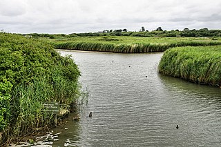
Titchfield Haven is a 134.5-hectare (332-acre) biological Site of Special Scientific Interest north-west of Gosport in Hampshire. Most of it is a local nature reserve and a national nature reserve. It is part of Solent and Southampton Water Ramsar site and Special Protection Area.
