
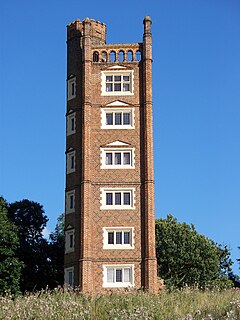
Freston Tower is a six-storey red brick folly south of Ipswich, Suffolk in the village of Freston. It stands on the banks of the River Orwell.
Freston Tower is a six-storey red brick folly south of Ipswich, Suffolk in the village of Freston. It stands on the banks of the River Orwell.
Arguably the oldest folly in England, the tower has various claims for construction dates, ranging from the 15th to 17th centuries. [1]
There is a legend that the tower was built by "Lord de Freston" in the 15th century for his daughter Ellen, so she could study a different subject on a different floor six days of the week: the 1st floor was dedicated to reception, the 2nd to tapestry working, the 3rd to music, the 4th to painting, the 5th to literature and the 6th to astronomy, complete with instruments for taking observations. [2] This was written about in a novel by Reverend Richard Cobbold entitled Freston Tower: A Tale of the Times of Cardinal Wolsey (1850) and so should not be taken as fact. [2] There is much evidence against this legend, such as documents apparently referring to the construction of the tower within the twelve years preceding 1569, and it is likely that the tower was constructed by Edmond Latymer as a lookout over Freston Reach of the River Orwell. [2] There are further descriptions suggesting a construction date of 1655. [3]
The Landmark Trust, a historical building preservation charity and the current owner of Freston Tower, suggests the tower "was built in 1578 by a wealthy Ipswich merchant called Thomas Gooding". [4]
By 1730, the tower was available to let, complete with furniture. [3] Between 1772 and 1779, Freston Tower was used for small-pox patients under inoculation. [3]
Most recently owned by Claire Hunt until 1999, Freston Tower was donated to the current owner the Landmark Trust, a charity that rescues and restores historical buildings. [5] In 2004, the tower became available to let as a holiday home. [6]

Suffolk is a ceremonial county of England in East Anglia. It borders Norfolk to the north, Cambridgeshire to the west and Essex to the south; the North Sea lies to the east. The county town is Ipswich; other important towns include Lowestoft, Bury St Edmunds, Newmarket, and Felixstowe which has one of the largest container ports in Europe.
Ipswich is a port town and borough in Suffolk, England, of which it is the county town. The town is located in East Anglia about 16km (10mi) away from the mouth of the River Orwell and the North Sea. Ipswich is both on the Great Eastern Main Line railway and the A12 road; it is 108km (67mi) north-east of London, 72km (45mi) east-southeast of Cambridge and 64km (40mi) south of Norwich. Ipswich is surrounded by two Areas of Outstanding Natural Beauty (AONB): Suffolk Coast and Heaths and Dedham Vale.

The River Gipping is the source river for the River Orwell in the county of Suffolk in East Anglia, England, which is named from the village of Gipping, and which gave its name to the former Gipping Rural District. The name is unrelated to the name of Ipswich. although the County Town takes its name from Gippeswic. It rises near Mendlesham Green and flows in a south-westerly direction to reach Stowmarket. From there it flows towards the south or south east, passing through Needham Market and a number of villages to reach Ipswich, where it becomes the Orwell. The river has supplied power to a number of watermills, several of which are still standing. None is operational, although the mill at Baylham retains most of its machinery, and is the only complete mill on the river.

In architecture, a folly is a building constructed primarily for decoration, but suggesting through its appearance some other purpose, or of such extravagant appearance that it transcends the range of usual garden buildings.

Perrott's Folly, grid reference SP047862, also known as The Monument, or The Observatory, is a 29-metre (96-foot) tall tower, built in 1758. It is a Grade II* listed building in the Edgbaston area of Birmingham, United Kingdom.
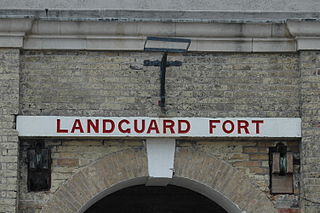
Landguard Fort is a fort at the mouth of the River Orwell outside Felixstowe, Suffolk, designed to guard the mouth of the river. It is now open to the public.

Orford Castle is a castle in Orford in the English county of Suffolk, 12 miles (19 km) northeast of Ipswich, with views over Orford Ness. It was built between 1165 and 1173 by Henry II of England to consolidate royal power in the region. The well-preserved keep, described by historian R. Allen Brown as "one of the most remarkable keeps in England", is of a unique design and probably based on Byzantine architecture. The keep stands within the earth-bank remains of the castle's outer fortifications.
Ravenswood is a district within Ipswich, Suffolk, UK. It is sited on the old Ipswich Airport to the south-east of the town. The area has grown rapidly due to private housing development. The old airport building has been transformed into small flats, and part of the terminal has been redeveloped for commercial purposes.
The Landmark Trust is a British building conservation charity, founded in 1965 by Sir John and Lady Smith, that rescues buildings of historic interest or architectural merit and then makes them available for holiday rental. The Trust's headquarters is at Shottesbrooke in Berkshire.

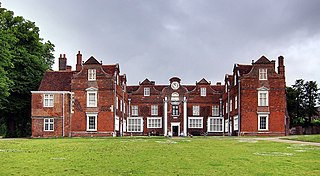
Woolverstone Hall is a large country house, now in use as a school and available at times as a function venue, located 5 miles (8.0 km) south of the centre of Ipswich, Suffolk, England. It is set in 80 acres (320,000 m2) on the banks of the River Orwell. Built in 1776 for William Berners by the architect John Johnson of Leicestershire, it is an outstanding example of English Palladian architecture and is a Grade I listed building while associated buildings are Grade II. From 1951 to 1990, it housed Woolverstone Hall School, a boarding school operated by London County Council (LCC).

All Saints and St Nicholas, South Elmham is a civil parish in the north of the English county of Suffolk. It is 5 miles (8.0 km) south of the market town of Bungay and the same distance north-west of Halesworth and east of Harleston. The parish is in the East Suffolk district and is one of the parishes that make up the area around Bungay known as The Saints. It includes the settlements of All Saints, South Elmham and St Nicholas, South Elmham.
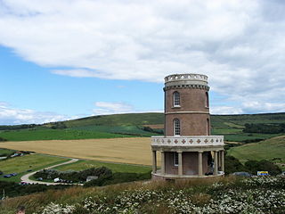
Clavell Tower, also known as Clavell Folly or the Kimmeridge Tower, is a Grade II listed Tuscan style tower built in 1830. It lies on the Jurassic Coast, on the top of Hen Cliff just east of Kimmeridge Bay in the Isle of Purbeck in Dorset, England. It is now a Landmark Trust property and in August 2006 was moved 25 metres (82 ft) back from the crumbling cliff edge.

The Port of Ipswich can be dated to c.625. The name Ipswich was originally Gippeswyc, referring to the River Gyppes with a suffix derived from the Scandinavian term vik, which had evolved from meaning bay or inlet to mean landing-place, following the proliferation of merchants requiring places to unload their goods and conduct trade. Since 1997 the port has been run by Associated British Ports.

St Lawrence Church is a Grade II* listed church in Ipswich, Suffolk, that is now used as a community centre. The 15th-century church has the oldest ring of five church bells in the world.

The Ipswich Waterfront, often referred to as just "the waterfront", is a cultural and historically significant area surrounding the marina in the town of Ipswich, Suffolk. The modern dock was constructed in 1842 and the area was a hive of industry up until the 1970s, at the time of completion, the dock was known as 'the biggest and most important enclosed dock in the kingdom'. Although the dock as it stands was constructed in 1842, the area was used for trade as far back as the 7th century. The decline of industry in the town resulted in the area being transformed into a trendy area of Ipswich, the waterfront is now characterised by its marina, known as Neptune Marina, as well as its mix of classical and postmodern architecture which includes multiple high-rise apartment buildings, restaurants, bars and cafés. The waterfront is also home to the main campus of the regions university, the University of Suffolk.
Freston is a small village and civil parish in the Babergh district, in the county of Suffolk, England, located on the Shotley Peninsula, 4 miles south-east of Ipswich. In 2001 the parish had a population of 122, reducing slightly to 120 at the 2011 Census.

St Mary's Church is a redundant Church of England parish church in the civil parish of Chilton, Suffolk, England. It is a Grade I listed building, and is in the care of the Churches Conservation Trust.
The Shotley Peninsula is a rural area east of the A137 Ipswich-Colchester road located between the rivers Stour and Orwell in Suffolk, England. The peninsula is named after the settlements of Shotley and Shotley Gate which are situated near its south-eastern tip. Other villages on the peninsula include Chelmondiston, Erwarton (Arwarton), Freston, Harkstead, Holbrook, Stutton, Tattingstone, Wherstead and Woolverstone.

Ipswich Blackfriars was a medieval religious house of Friars-preachers (Dominicans) in the town of Ipswich, Suffolk, England, founded in 1263 by King Henry III and dissolved in 1538. It was the second of the three friaries established in the town, the first being the Greyfriars, a house of Franciscan Friars Minors, and the third the Ipswich Whitefriars of c. 1278–79. The Blackfriars were under the Visitation of Cambridge.

The A1094 is an A road in the English county of Suffolk. It is around 7 miles (11 km) in length. The road runs from a junction off the A12 trunk road at Friday Street in Benhall to Aldeburgh on the North Sea coast. The road is single carriageway throughout.