Samford Hundred

Last updated • 1 min readFrom Wikipedia, The Free Encyclopedia

Samford was a hundred of Suffolk, consisting of 44,940 acres (181.9 km2). It was situated to the south and south west of Ipswich.

The hundred was bounded by the River Orwell to the east, Essex to the south, the River Brett (and Shelley parish) to the west, and the parish boundaries of Burstall, Hintlesham, and Sproughton to the north.

Parishes

Suffolk hundreds Suffolk Hundreds 1830.png
Suffolk hundreds

Samford Deanery, the modern ecclesiastic administrative area, takes its name fom Samford Hundred and previously covered the whole of the old Samford Hundred. [1] Seven of the westernmost parishes have been more recently allocated to Hadleigh Deanery. Samford Hundred consisted of the following 28 parishes: [2]

ParishArea (acres)Modern Deanery
Belstead 1012Samford
Bentley 2801Samford
Brantham 1922Samford
Burstall 766Samford
Capel St Mary 1910Samford
Chattisham 714Hadleigh
Chelmondiston 1293Samford
Copdock 932Samford
East Bergholt 3064Samford
Erwarton 1318Samford
Freston 1414Samford
Great Wenham 1108Samford
Harkstead 1727Samfod
Higham 863Hadleigh
Hintlesham 2828Hadleigh
Holbrook 2203Samford
Holton St Mary 810Hadleigh
Little Wenham 970Samford
Raydon 2335Hadleigh
Shelley 928Hadleigh
Shotley 2051Samford
Sproughton 2380Samford
Stratford St Mary 1432Hadleigh
Stutton 2138Samford
Tattingstone 1637Samford
Washbrook 1414Samford
Wherstead 2019Samford
Woolverstone 951Samford

Related Research Articles

<span class="mw-page-title-main">Babergh District</span> Non-metropolitan district in England

Babergh District is a local government district in Suffolk, England. In 2021 it had a population of 92,300. The district is primarily a rural area, containing just two towns, Sudbury and Hadleigh, which was the administrative centre until 2017 when the council moved to shared offices with neighbouring Mid Suffolk District Council in Ipswich, outside either district. The district is named after the medieval Babergh Hundred, which covered part of the area.

<span class="mw-page-title-main">Ulleråker Hundred</span>

Ulleråker Hundred, or Ulleråkers härad, was a hundred of Uppland and Uppsala County in Sweden.

<span class="mw-page-title-main">Edenham</span> Village and civil parish in the South Kesteven district of Lincolnshire, England

Edenham is a village and civil parish in the South Kesteven district of Lincolnshire, England. It is approximately 3 miles (5 km) north-west of Bourne, and on the A151 road. While the civil parish is called 'Edenham', the parish council is called Edenham, Grimsthorpe, Elsthorpe & Scottlethorpe Parish Council. The population of the civil parish at the 2011 census was 291.

<span class="mw-page-title-main">Carlby</span> Village and civil parish in Lincolnshire, England

Carlby is a small village and civil parish in the district of South Kesteven in Lincolnshire, England. The population of the civil parish at the 2011 census was 542.

<span class="mw-page-title-main">Thedwastre Hundred</span> Hundred of the county of Suffolk, England

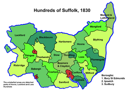
Thedwastre was a hundred of the county of Suffolk, England covering an area of 40,362 acres (163.34 km2). It formed part of the Liberty of Saint Edmund, under the jurisdiction of the abbots of Bury St Edmunds.

<span class="mw-page-title-main">Babergh Hundred</span>

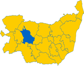
Babergh was a hundred of Suffolk, consisting of 71,882 acres (290.90 km2). Its name survives in that of Babergh District, the local government district of southern Suffolk that includes the former hundred as well as those of Cosford and Samford.

<span class="mw-page-title-main">Cosford Hundred</span> Hundred of Suffolk, England

Cosford was a hundred of Suffolk, consisting of 30,712 acres (124.29 km2).

<span class="mw-page-title-main">Lackford Hundred</span> Former administrative division of Suffolk

Lackford was a hundred of Suffolk, consisting of 83,712 acres (338.77 km2).

Risbridge is a hundred of Suffolk, consisting of 58,468 acres (236.61 km2).

Stow was a hundred of Suffolk, consisting of 22,710 acres (91.9 km2).

<span class="mw-page-title-main">Bosmere and Claydon Hundred</span>

Bosmere and Claydon was a hundred of Suffolk, consisting of 31,850 acres (128.9 km2).

<span class="mw-page-title-main">Hoxne Hundred</span>

Hoxne was a hundred of Suffolk, with an area of 55,648 acres (225.20 km2).

<span class="mw-page-title-main">Loes Hundred</span> A hundred of Suffolk

Loes was a hundred of Suffolk, with an area of 31,321 acres (126.75 km2).

<span class="mw-page-title-main">Thredling Hundred</span>

Thredling was a hundred of Suffolk, and at just under 10,000 acres (40 km2) the smallest of Suffolk's 21 hundreds.

<span class="mw-page-title-main">Carlford Hundred</span> Area of land in Suffolk, England

Carlford is a hundred of Suffolk, consisting of 25,461 acres (103.04 km2).

<span class="mw-page-title-main">Colneis Hundred</span>

Colneis is a hundred of Suffolk, consisting of 16,712 acres (67.63 km2).

Plomesgate is a hundred of Suffolk, consisting of 41,579 acres (168.26 km2).

Mutford and Lothingland was a hundred of Suffolk, with an area of 33,368 acres (135.04 km2). Lowestoft Ness, the most easterly point of Great Britain fell within its bounds.

<span class="mw-page-title-main">Wangford Hundred</span> Historical division of Suffolk, England

Wangford was a hundred of Suffolk, England, consisting of 34,679 acres (140.34 km2).

<span class="mw-page-title-main">Wilford Hundred</span>

Wilford is a hundred of Suffolk, consisting of 31,500 acres (127 km2).

References

  1. "Shop - Samford Deanery - Area". suffolkfhs.co.uk. Suffol Family History Society. Retrieved 19 February 2024.
  2. 1841 Census

52°00′N1°07′E / 52.0°N 1.11°E / 52.0; 1.11