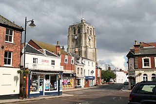
Beccles is a market town and civil parish in the English county of Suffolk. The town on the A145 and A12 roads, situated 16 miles (26 km) south-east of Norwich and 33 miles (53 km) north-northeast of Ipswich. Nearby towns include Lowestoft to the east and Great Yarmouth to the north-east. The town lies on the River Waveney on the edge of The Broads National Park.

The River Waveney is a river which forms the boundary between Suffolk and Norfolk, England, for much of its length within The Broads. The earliest attestation of the name is from 1275, Wahenhe, from *wagen + ea, meaning the river by a quagmire.

Waveney was a local government district in Suffolk, England, named after the River Waveney that formed its north-east border. The district council was based in Lowestoft, the major settlement in Waveney. The other towns in the district were Beccles, Bungay, Halesworth and Southwold.

East Suffolk, along with West Suffolk, was created in 1888 as an administrative county of England. The administrative county was based on the eastern quarter sessions division of Suffolk. East Suffolk County Council's headquarters were at East Suffolk County Hall in Ipswich.
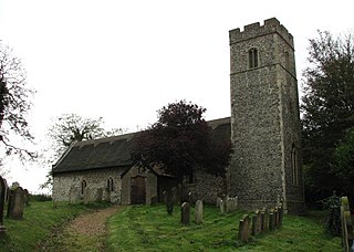
Halesworth is a market town, civil parish and electoral ward in north-eastern Suffolk, England. The population stood at 4,726 in the 2011 Census. It lies 15 miles (24 km) south-west of Lowestoft, on a tributary of the River Blyth, nine miles upstream from Southwold. The town is served by Halesworth railway station on the Ipswich–Lowestoft East Suffolk Line. It is twinned with Bouchain in France and Eitorf in Germany. Nearby villages include Cratfield, Wissett, Chediston, Walpole, Blyford, Linstead Parva, Wenhaston, Thorington, Spexhall, Bramfield, Huntingfield, Cookley and Holton.

Great Yarmouth is a constituency represented in the House of Commons of the Parliament of the United Kingdom since the 2024 general election by Rupert Lowe of Reform UK.

South Norfolk is a constituency in the House of Commons of the UK Parliament represented by Ben Goldsborough, a member of the Labour Party, after winning the seat in the 2024 general election.

Suffolk Coastal is a parliamentary constituency in the county of Suffolk, England, which has been represented in the House of Commons of the UK Parliament since 2024 by Jenny Riddell-Carpenter, a Labour Party Member of Parliament (MP).
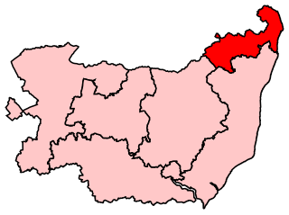
Waveney was a constituency of in the House of Commons of the UK Parliament that existed from 1983 to 2024. It returned one Member of Parliament (MP) to the House of Commons of the Parliament of the United Kingdom.
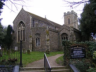
Barnby is a village and civil parish in the East Suffolk district of the English county of Suffolk. The village is 5 miles (8.0 km) west of Lowestoft and 3 miles (4.8 km) east of Beccles in the north of the county. It is effectively merged with the village of North Cove which constitutes a separate parish.
Lothingland is an area in the English counties of Suffolk and Norfolk on the North Sea coast. It is bound by the River Yare and Breydon Water to the north, the River Waveney to the west and Oulton Broad to the south, and includes the parts of Lowestoft north of Lake Lothing.
Eye was a parliamentary constituency, represented in the House of Commons of the Parliament of the United Kingdom, encompassing an area around the market town and civil parish of Eye, Suffolk.
East Suffolk was a county constituency in Suffolk, England. It elected two Members of Parliament to the House of Commons of the Parliament of the United Kingdom by the bloc vote system of election.

The A144 is an A road in the English county of Suffolk. It runs from the town of Bungay, close to the border with Norfolk, to the A12 trunk road near the village of Darsham, passing through the market town of Halesworth. It is around 14 miles (23 km) in length and is single carriageway throughout.

Mutford and Lothingland Rural District was a rural district within the administrative county of East Suffolk between 1894 and 1934. It was created out of the earlier Mutford and Lothingland rural sanitary district. It was named after the historic hundred of Mutford and Lothingland, whose boundaries it closely matched.

East Suffolk is a local government district in Suffolk, England. The largest town is Lowestoft, which contains Ness Point, the easternmost point of the United Kingdom. The second largest town is Felixstowe, which has the country's largest container port. On the district's south-western edge it includes parts of the Ipswich built-up area. The rest of the district is largely rural, containing many towns and villages, including several seaside resorts. Its council is based in the village of Melton. The district was formed in 2019 as a merger of the two previous districts of Suffolk Coastal and Waveney. In 2021 it had a population of 246,058. It is the most populous district in the country not to be a unitary authority.

Waveney Valley is a constituency of the House of Commons in the UK Parliament, created following the 2023 Periodic Review of Westminster constituencies. Since its first election in 2024, it has been represented by Adrian Ramsay of the Green Party and is the first Green seat in the East of England.


