Geography of England

Last updated

Geography of England
Satellite image of England and Wales.jpg
Satellite image including England
England in United Kingdom.svg
ContinentEurope
Region British Isles
Area
  Total132,930 km2 (51,320 sq mi)
Coastline3,200 km (2,000 mi)
Borders
Highest point Scafell Pike
978 m (3,209 ft)
Lowest point Holme Fen, −2.75 m (−9 ft)
Longest river River Severn (shared with Wales)
354 km (220 mi)
Longest river entirely within England is the River Thames.
346 km (215 mi)
Largest lake Windermere
14.73 km2 (5.69 sq mi)
Climate Oceanic "British" climate
with small areas of Subarctic climate
TerrainMostly low hills and plains, especially in the south, Midlands and east. Upland or mountainous terrain prevails in the north and parts of the west.
Natural resourcesIron, zinc, potash, silica sand, fish, timber, wildlife, petroleum, natural gas, hydropower, wind power, lead, tin, copper, china clay, arable land, and coal
Natural hazards European windstorms, floods, few and small tornadoes
Environmental issues climate change, rising sea levels, renewable energy, waste disposal, water pollution, population density
References
[1] [2]

England comprises most of the central and southern two-thirds of the island of Great Britain, in addition to a number of small islands of which the largest is the Isle of Wight. England is bordered to the north by Scotland and to the west by Wales. It is closer to continental Europe than any other part of mainland Britain, divided from France only by a 33 km (21 mi) sea gap, the English Channel. [3] The 50 km (31 mi) Channel Tunnel, [4] near Folkestone, directly links England to mainland Europe. The English/French border is halfway along the tunnel. [5]

Contents

Most of England consists of low hills and plains, with upland and mountainous terrain in the north and west. Uplands in the north include the Pennines, an upland chain dividing east and west, the Lake District, containing the highest mountains in the country, the Cheviot Hills across the Anglo-Scottish border, and the North York Moors near the North Sea. Uplands in the west include Dartmoor and Exmoor in the south west and the Shropshire Hills near Wales. The approximate dividing line between terrain types is often indicated by the Tees–Exe line. To the south of that line, there are larger areas of flatter land, including East Anglia and the Fens, although hilly areas include the Cotswolds, the Chilterns, and the North and South Downs.

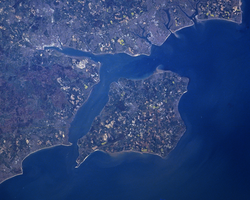
The largest natural harbour in England is at Poole, on the south-central coast. Some regard it as the second largest harbour in the world, after Sydney, Australia, although this fact is disputed (see harbours for a list of other large natural harbours).

Climate

England 1971–2000 [6]
Climate chart (explanation)
J
F
M
A
M
J
J
A
S
O
N
D
 
 
84
 
 
7
1
 
 
60
 
 
7
1
 
 
67
 
 
9
2
 
 
57
 
 
12
4
 
 
56
 
 
15
6
 
 
63
 
 
18
9
 
 
54
 
 
21
11
 
 
67
 
 
21
11
 
 
73
 
 
18
9
 
 
84
 
 
14
7
 
 
84
 
 
10
4
 
 
91
 
 
7
2
Average max. and min. temperatures in °C
Precipitation totals in mm
Imperial conversion
JFMAMJJASOND
 
 
3.3
 
 
44
34
 
 
2.4
 
 
44
34
 
 
2.6
 
 
49
36
 
 
2.2
 
 
53
38
 
 
2.2
 
 
60
43
 
 
2.5
 
 
65
48
 
 
2.1
 
 
69
53
 
 
2.6
 
 
69
52
 
 
2.9
 
 
64
49
 
 
3.3
 
 
56
44
 
 
3.3
 
 
49
38
 
 
3.6
 
 
45
36
Average max. and min. temperatures in °F
Precipitation totals in inches

England has a temperate climate, with plentiful rainfall all year round. It has a milder climate than many places at similar latitudes: for example Newfoundland in Canada, and Sakhalin in Russia. The seasons are quite variable in temperature; however temperatures rarely fall below −5 °C (23 °F) or rise above 30 °C (86 °F). The prevailing wind is from the south-west, frequently bringing mild and wet weather to England from the Atlantic Ocean. It is driest in the east and warmest in the south, which is closest to the European mainland. Snowfall can occur in winter and early spring, although it is not very common away from high ground. England has warmer maximum and minimum temperatures throughout the year than the other countries of the UK, though Wales has milder minima from November to February, and Northern Ireland has warmer maxima from December to February. England is also sunnier throughout the year, but unlike Wales, Northern Ireland and Scotland, the sunniest month is July, totalling around 192.8 hours on average.

British Isles hardiness zones UK zonemap.png
British Isles hardiness zones

The highest temperature recorded in England is 40.3 °C (104.5 °F) on 19 July 2022 at Coningsby. [7] The lowest temperature recorded in England is −26.1 °C (−15.0 °F) on 10 January 1982 at Edgmond, Shropshire. The climate of south-west England is rather distinct and somewhat milder than the rest of England. Crops, flowers and plants can be grown earlier there than in the rest of England and the UK.

England mainly lies within hardiness zone 8, but the Pennines and Cumbrian Mountains lie in the colder zone 7, and south west England, the Irish Sea coast, South coast and London lie in the warmer zone 9. A very small area, the Isles of Scilly, lies in the warmest zone in the British Isles, zone 10 which is close to subtropical.

Climate data for England
MonthJanFebMarAprMayJunJulAugSepOctNovDecYear
Mean daily maximum °C (°F)6.6
(43.9)
6.9
(44.4)
9.3
(48.7)
11.7
(53.1)
15.4
(59.7)
18.1
(64.6)
20.6
(69.1)
20.5
(68.9)
17.5
(63.5)
13.6
(56.5)
9.5
(49.1)
7.4
(45.3)
13.1
(55.6)
Mean daily minimum °C (°F)1.1
(34.0)
1.0
(33.8)
2.4
(36.3)
3.6
(38.5)
6.3
(43.3)
9.1
(48.4)
11.4
(52.5)
11.2
(52.2)
9.3
(48.7)
6.6
(43.9)
3.5
(38.3)
2.0
(35.6)
5.6
(42.1)
Average rainfall mm (inches)84.2
(3.31)
60.1
(2.37)
66.5
(2.62)
56.8
(2.24)
55.9
(2.20)
62.9
(2.48)
54.1
(2.13)
66.7
(2.63)
73.3
(2.89)
83.6
(3.29)
83.5
(3.29)
90.4
(3.56)
838.0
(32.99)
Average rainy days13.410.412.110.19.89.88.59.410.211.812.513.1131.2
Mean monthly sunshine hours 50.567.7102.5145.2189.9179.4192.8184.1135.0101.365.243.91,457.4
Source: Met Office [6] (1971–2000 averages)

Geology

The Geology of England is mainly sedimentary. The youngest rocks are in the south east, progressing in age in a north-westerly direction. The Tees–Exe line marks the division between younger, softer and low-lying rocks in the south east and older, harder, and generally a higher relief in the north-west. The geology of England is recognisable in the landscape of its counties, for instance Cumbria, Kent and Norfolk all have very distinct and very different looks from each other. The geology of Northern England and Western England tends to be somewhat closer to that of its near neighbours, Wales and Scotland, with the geology of Southern England and Eastern England being more aligned with that found across the North Sea and English Channel in Northern France, Belgium, and the Netherlands.

Geological features

Geological resources

and less abundantly,

Major towns and cities

London is, by far, the largest urban area in England and one of the largest and busiest cities in the world. Other cities, mainly in central and northern England, are of substantial size and influence. The list of England's largest cities or urban areas is open to debate because, although the normal meaning of city is "a continuously built-up urban area", this can be hard to define, particularly because administrative areas in England often do not correspond with the limits of urban development, and many towns and cities have, over the centuries, grown to form complex urban agglomerations. [9] [10] For the official definition of a UK (and therefore English) city, see City status in the United Kingdom .

According to the ONS urban area populations for continuous built-up areas, these are the 15 largest conurbations (population figures from the 2001 census):

RankUrban area [11] Population
(2001 Census)
Localities
[ clarification needed ]
Major localities
1 Greater London Urban Area 8,278,25167 Croydon, Barnet, Ealing, Bromley
2 West Midlands Urban Area 2,284,09322 Birmingham, Wolverhampton, Dudley, Walsall
3 Greater Manchester Urban Area 2,240,23057 Manchester, Salford, Bolton, Stockport, Oldham
4 West Yorkshire Urban Area 1,499,46526 Leeds, Bradford, Huddersfield, Wakefield
5 Tyneside 879,99625 Newcastle upon Tyne, North Shields, South Shields, Gateshead, Jarrow
6 Liverpool Urban Area 816,2168 Liverpool, St Helens, Bootle, Huyton-with-Roby
7 Nottingham Urban Area 666,35815 Nottingham, Beeston and Stapleford, Carlton, Long Eaton
8 Sheffield Urban Area 640,7207 Sheffield, Rotherham, Chapeltown, Mosborough/Highlane
9 Bristol Urban Area 551,0667 Bristol, Kingswood, Mangotsfield, Stoke Gifford
10 Brighton/Worthing/Littlehampton 461,18110 Brighton, Worthing, Hove, Littlehampton, Shoreham, Lancing
11 Portsmouth Urban Area 442,2527 Portsmouth, Gosport, Waterlooville, Fareham
12 Leicester Urban Area 441,21312 Leicester, Wigston, Oadby, Birstall
13 Bournemouth Urban Area 383,7135 Bournemouth, Poole, Christchurch, New Milton
14 Reading/Wokingham Urban Area 369,8045 Reading, Bracknell, Wokingham, Crowthorne
15 Teesside 365,3237 Middlesbrough, Stockton-on-Tees, Redcar, Billingham

The largest cities in England are as follows (in alphabetical order):

Physical geography

Extreme points

England and Wales from space SatImEng.PNG
England and Wales from space

The extreme points of England are:

LocationMainland onlyIncluding islands
  • Northernmost point
  • Northernmost settlement
  • Southernmost point
  • Southernmost settlement
  • Westernmost point
  • Westernmost settlement
  • Easternmost point
  • Easternmost settlement

Topography, mountains and hills

England is generally lower and flatter than the rest of the UK, but has two main divisions in its form – the lowland areas of the south, east, and midlands and the more rugged and upland areas of the north and west. East Anglia is the lowest area of England, having no high hills or mountains and hosting an area of the Fens, the lowest area of England. The highest area of England is the North West, which contains England's highest hills and mountains, including its highest – Scafell Pike.

In England, a mountain is officially defined as land over 600 metres, so most fall in Northern England. Some hill and mountain chains in England are:

Cities

Cities with the highest urban elevation include Sheffield, Bradford, Stoke-on-Trent and Birmingham. Low-lying cities near sea level include London, Liverpool, Norwich and York.

Islands

A map of British Isles EEZs and surrounding nations. Internal UK borders are represented by thin lines. English eez.PNG
A map of British Isles EEZs and surrounding nations. Internal UK borders are represented by thin lines.
The Isle of Wight Wight.png
The Isle of Wight

The main English islands by area and population are:

RankIslandArea (sq mi)Area (km2)
1 Isle of Wight 147.09380.99
2 Isle of Sheppey 36.3194.04
3 Hayling Island 10.3626.84
4 Foulness Island 10.0926.84
5 Portsea Island 9.3624.25
6 Canvey Island 7.1218.45
7 Mersea Island 6.9618.04
8 Walney Island 5.0112.99
9 Portland 4.4411.5
10 Wallasea Island 4.1110.65

English islands by population

RankIslandPopulation
(2001 UK census)
1 Portsea Island 147,088
2 Isle of Wight 132,731
3 Isle of Sheppey 37,852
4 Canvey Island 37,473
5 Hayling Island 16,887
6 Portland 12,800
7 Walney Island 11,391
8 Mersea Island about 7,200
9 Barrow Island 2,606
10 St Mary's 1,668
11 Thorney Island 1,079
12 Foulness 212
13 Tresco 180
14 Lindisfarne 162
15 St Martins 142
16 Roa Island about 100
17 Bryher 92
18 St Agnes 73
19 Lundy about 35

Rivers

The longest river in England is the River Severn which has its source in Wales, enters England at its confluence with the River Vyrnwy and flows into the Bristol Channel. The longest river entirely within England is the River Thames which flows through the English and British capital, London. The Vale of York and The Fens host many of England's larger rivers.

Coastline

England has 4,422 km (2,748 mi) of coastline, [13] much less than the deeply indented Scottish coastline. The English coastline varies a great deal by the seas and regions it borders. The North Sea coast of England is mainly flat and sandy with many dunes and is similar to coastlines across the sea in the Netherlands. The English North Sea coast is an important area of bird life and is a habitat for many shore and wading birds. Along the English Channel, the South Coast builds up into steep, white cliffs at Dover, which are often seen as an iconic symbol of England and Britain.

The White Cliffs of Dover White cliffs of dover 09 2004.jpg
The White Cliffs of Dover

The South Coast continues to the Isle of Wight, but eventually gives way to the Jurassic Coast of Dorset, a coastline rich in beauty, history and fossils.

Jurassic Coast. Gad cliff dorset.jpg
Jurassic Coast.

In Devon and Cornwall, the coastline becomes more rocky and steep, with numerous cliffs and tiny fishing villages along the coastline. This stretch of coastline stretches from Devon to Land's End in Cornwall, the westernmost part of mainland England. The coastline of Devon and Cornwall has similarities to that of Brittany in France directly opposite.

Following the coastline northwards the coast remains much the same as in south Devon and Cornwall but is besides the Celtic Sea until it eventually reaches the Bristol Channel, an important shipping and docking area.

The English coastline re-emerges again in North West England. The coastline here is similar to the North Sea coast in that it is mainly flat and sandy, with the only notable cliffs along this stretch of coast being at St Bees Head in Cumbria. The English Irish Sea coast is an important area of estuaries and bird life, with Wirral being a peninsula bounded by two rivers, the River Dee and the River Mersey. Liverpool and Merseyside are areas of high population and important industry along this coast, with tourist resorts of Southport and Blackpool being further to the north. The English Irish Sea coast hosts two important geographic areas, Morecambe Bay, a large bay, and the Furness and Walney Island areas. Further north into Cumbria the Sellafield Nuclear Power Station lies along this coast. The English section of the Irish Sea coast ends at the border with Scotland in the Solway Firth.

Durdle Door on the Jurassic Coast Durdle Door, Dorset (2004).jpg
Durdle Door on the Jurassic Coast

Seas bordering England are:

Largest lakes and reservoirs

Although the largest nation within the UK, England is relatively absent of large lakes, with many of its former wetlands being drained throughout the Middle Ages. Most of its largest lakes lie within the aptly named Lake District in Cumbria, Northern England.

England's largest lakes
LakeArea
1 Windermere 5.69 sq mi (14.7 km2)
2 Kielder Reservoir 3.86 sq mi (10.0 km2)
3 Ullswater 3.44 sq mi (8.9 km2)
4 Bassenthwaite Lake 2.06 sq mi (5.3 km2)
5 Derwent Water 2.06 sq mi (5.3 km2)

Human geography

Land use

The total land area of England, excluding inland water, is 130,310 km2 (50,313 sq mi). [1] Crops and fallow land accounts for 30% of the land area, grasses and rough grazing 36%, other agricultural land 5%, forest and woodland 8%, and urban development 21%. [14]

Neighbouring countries

England has two land borders: a 96 km (60 mi) border with Scotland that follows the Cheviot Hills and a 257 km (160 mi) border with Wales that loosely follows the route of Offa's Dyke. To the west, the Irish Sea separates England from Ireland and the Isle of Man; to the east, the North Sea separates England from Denmark, Germany, the Netherlands and Belgium and to the south, the English Channel separates England from France and the Channel Islands.

Economic geography

Night London Panorama with Full Moon.jpg

England boasts one of the largest economies in Europe and indeed the world, with an average GDP per capita of £22,907. England's economy is usually regarded as a mixed market economy, it has adopted many free market principles in contrast to the Rhine Capitalism of Europe, yet maintains an advanced social welfare infrastructure. The currency in England is the pound sterling, also known as the GBP. England prints its own banknotes which are also circulated in Wales. The economy of England is the largest part of the United Kingdom's economy.

Regional differences:

A map of England divided by the average GVA per capita in 2007 showing the distribution of wealth Map of NUTS 3 areas in England by GVA per capita (2007).png
A map of England divided by the average GVA per capita in 2007 showing the distribution of wealth

The strength of the English economy varies from region to region. GDP, and GDP per capita is highest in London. Generally the Northern and Western areas of England are the poorest, with the Southern and Eastern areas being the richest. The following table shows the GDP (2004) per capita of England as a whole and each of the nine regions.

RankPlaceGDP per capita
in Euros
England26 904
1.London44 401
2. South East 31 300
3. East of England 27 778
4. South West 27 348
5. East Midlands 26 683
6. West Midlands 25 931
7. North West 25 396
8. Yorkshire and the Humber 25 300
9. North East 22 886

Two of the 10 economically strongest areas in the European Union are in England. Inner London is number 1 with a €71 338 GDP per capita (303% above EU average);Berkshire, Buckinghamshire & Oxfordshire is number 7 with a €40 937 GDP per capita (174% above EU average).

Political geography

England, formerly a kingdom and independent country, united with Scotland to form what would eventually become the UK (Wales was treated as part of England at that time).

England is in a unique and controversial position of being a political entity within the UK and as of 2015 having no self-governance. England is represented by MPs in the British Parliament and matters relating only to England are also dealt with by the UK parliament. England was divided into a number of regions which also sent representatives to the European Parliament before Brexit.

See also

Related Research Articles

<span class="mw-page-title-main">Geography of the United Kingdom</span>

The United Kingdom is a sovereign state located off the north-western coast of continental Europe. With a total area of approximately 248,532 square kilometres (95,960 sq mi), the UK occupies the major part of the British Isles archipelago and includes the island of Great Britain, the north-eastern one-sixth of the island of Ireland and many smaller surrounding islands. It is the world's 7th largest island country. The mainland areas lie between latitudes 49°N and 59°N, and longitudes 8°W to 2°E. The Royal Observatory, Greenwich, in south-east London, is the defining point of the Prime Meridian.

<span class="mw-page-title-main">Cumbria</span> County of England

Cumbria is a ceremonial county in North West England. It borders the Scottish council areas of Dumfries and Galloway and Scottish Borders to the north, Northumberland and County Durham to the east, North Yorkshire to the south-east, Lancashire to the south, and the Irish Sea to the west. Its largest settlement is the city of Carlisle.

<span class="mw-page-title-main">Cumberland</span> Historic county of England

Cumberland is a historic county in North West England, covering part of the Lake District as well as the northern Pennines and the coast of Solway Firth. Cumberland had an administrative function from the 12th century until 1974, when it was subsumed into Cumbria, a larger administrative area which also covered Westmorland and parts of Yorkshire and Lancashire. In April 2023, Cumberland was revived as an administrative entity when Cumbria County Council was abolished and replaced by two unitary authorities, one of which is named Cumberland and includes most of the historic county, with the exception of Penrith and the surrounding area.

<span class="mw-page-title-main">Pennines</span> Range of uplands in Northern England

The Pennines, also known as the Pennine Chain or Pennine Hills, are a range of uplands mainly located in Northern England. Commonly described as the "backbone of England" because of its length and position, the range runs from the north Midlands to North East England, near the Anglo-Scottish border. The Peak District is the southern end of the range, rising northwards from its foothills near the Trent Valley in northern Staffordshire, and further north into eastern Cheshire and southern Derbyshire. Beyond this are the South Pennines, Yorkshire Dales, and North Pennines, ending at the Tyne Gap. Beyond the gap are the Border Moors and Cheviot Hills, which are included in some definitions of the range.

<span class="mw-page-title-main">Northumberland National Park</span> National park in Northumberland, England

Northumberland National Park is the northernmost national park in England. It covers an area of more than 1,050 square kilometres (410 sq mi) between the Scottish border in the north to just south of Hadrian's Wall, and it is one of least visited of the National Parks. The park lies entirely within Northumberland, covering about a quarter of the county.

<span class="mw-page-title-main">Geology of Great Britain</span> Overview of the geology of Great Britain

The geology of Great Britain is renowned for its diversity. As a result of its eventful geological history, Great Britain shows a rich variety of landscapes across the constituent countries of England, Wales and Scotland. Rocks of almost all geological ages are represented at outcrop, from the Archaean onwards.

<span class="mw-page-title-main">Northern England</span> Cultural area of Great Britain

Northern England, is the northern area of England. It broadly corresponds to the former borders of Angle Northumbria, the Anglo-Scandinavian Kingdom of Jorvik and the Brythontic Celtic Hen Ogledd kingdoms.

<span class="mw-page-title-main">Cross Fell</span> Mountain in Cumbria, England

Cross Fell is the highest mountain in the Pennines of Northern England and the highest point in England outside the Lake District. It is located in the North Pennines Area of Outstanding Natural Beauty. It lies within the county of Cumbria and the historic county boundaries of Cumberland.

<span class="mw-page-title-main">Geography of Wales</span> Overview of the geography of Wales

Wales is a country that is part of the United Kingdom and whose physical geography is characterised by a varied coastline and a largely upland interior. It is bordered by England to its east, the Irish Sea to its north and west, and the Bristol Channel to its south. It has a total area of 2,064,100 hectares and is about 170 mi (274 km) from north to south and at least 60 mi (97 km) wide. It comprises 8.35 percent of the land of the United Kingdom. It has a number of offshore islands, by far the largest of which is Anglesey. The mainland coastline, including Anglesey, is about 1,680 mi (2,704 km) in length. As of 2014, Wales had a population of about 3,092,000; Cardiff is the capital and largest city and is situated in the urbanised area of South East Wales.

<span class="mw-page-title-main">Southern Uplands</span> Southernmost and least populous region of Scotland

The Southern Uplands are the southernmost and least populous of mainland Scotland's three major geographic areas. The term is used both to describe the geographical region and to collectively denote the various ranges of hills and mountains within this region. An overwhelmingly rural and agricultural region, the Southern Uplands are partly forested and contain many areas of open moorland - the hill names in the area are congruent with these characteristics.

<span class="mw-page-title-main">Geography of Scotland</span> Geographical features of Scotland

The geography of Scotland is varied, from rural lowlands to unspoilt uplands, and from large cities to sparsely inhabited islands. Located in Northern Europe, Scotland comprises the northern third of the island of Great Britain as well as 790 surrounding islands encompassing the major archipelagos of the Shetland Islands, Orkney Islands and the Inner and Outer Hebrides. The only land border is with England, which runs for 96 miles in a northeasterly direction from the Solway Firth in the west to the North Sea on the east coast. Separated by the North Channel, the island of Ireland lies 13 nautical miles from Mull of Kintyre on the Scottish mainland. Norway is located 190 nmi (350 km) northeast of Scotland across the North Sea. The Atlantic Ocean, which fringes the coastline of western and northern Scotland and its islands, influences the temperate, maritime climate of the country.

<span class="mw-page-title-main">Grisedale Pike</span> Mountain in the English Lake District, Cumbria, England

Grisedale Pike is a fell in the Lake District, Cumbria, England, situated 4+12 miles west of the town of Keswick in the north-western sector of the national park. At a height of 791 metres it is the 40th-highest Wainwright in the Lake District; it also qualifies as a Hewitt, Marilyn and Nuttall. Grisedale Pike presents a striking appearance when viewed from the east, particularly from the vicinity of Keswick. It possesses two subsidiary summits: one unnamed ; the other Hobcarton End.

<span class="mw-page-title-main">Anglo-Scottish border</span> 96-mile long border between England and Scotland

The Anglo-Scottish border is a border separating Scotland and England which runs for 96 miles (154 km) between Marshall Meadows Bay on the east coast and the Solway Firth in the west.

<span class="mw-page-title-main">Mountains and hills of England</span>

The mountains and hills of England comprise very different kinds of terrain, from a mountain range which reaches almost 1,000 metres high, to several smaller areas of lower mountains, foothills and sea cliffs. Most of the major upland areas have been designated as Areas of Outstanding Natural Beauty (AONB) or national parks. The highest and most extensive areas are in the north and west, while the midlands, south-east and east of the country tend to be low-lying.

<span class="mw-page-title-main">Outline of England</span> Overview of and topical guide to England

The following outline is provided as an overview of and topical guide to England:

<span class="mw-page-title-main">Cheviot Hills</span> Upland between England and Scotland

The Cheviot Hills, or sometimes The Cheviots, are a range of uplands straddling the Anglo-Scottish border between Northumberland and the Scottish Borders. The English section is within the Northumberland National Park. The range includes The Cheviot, plus Hedgehope Hill to the east, Windy Gyle to the west, and Cushat Law and Bloodybush Edge to the south.

A National Character Area (NCA) is a natural subdivision of England based on a combination of landscape, biodiversity, geodiversity and economic activity. There are 159 National Character Areas and they follow natural, rather than administrative, boundaries. They are defined by Natural England, the UK government's advisors on the natural environment.

The geology of Northumberland in northeast England includes a mix of sedimentary, intrusive and extrusive igneous rocks from the Palaeozoic and Cenozoic eras. Devonian age volcanic rocks and a granite pluton form the Cheviot massif. The geology of the rest of the county is characterised largely by a thick sequence of sedimentary rocks of Carboniferous age. These are intruded by both Permian and Palaeogene dykes and sills and the whole is overlain by unconsolidated sediments from the last ice age and the post-glacial period. The Whin Sill makes a significant impact on Northumberland's character and the former working of the Northumberland Coalfield significantly influenced the development of the county's economy. The county's geology contributes to a series of significant landscape features around which the Northumberland National Park was designated.

The geology of Northumberland National Park in northeast England includes a mix of sedimentary, intrusive and extrusive igneous rocks from the Palaeozoic and Cenozoic eras. Devonian age volcanic rocks and a granite pluton form the Cheviot massif. The geology of the rest of the national park is characterised largely by a thick sequence of sedimentary rocks of Carboniferous age. These are intruded by Permian dykes and sills, of which the Whin Sill makes a significant impact in the south of the park. Further dykes were intruded during the Palaeogene period. The whole is overlain by unconsolidated sediments from the last ice age and the post-glacial period.

References

  1. 1 2 "Standard Area Measurements (Latest) for Administrative Areas in the United Kingdom (V2)". Open Geography Portal. Office for National Statistics. 5 April 2023. Retrieved 3 December 2023.
  2. "A Beginners Guide to UK Geography (2023)". Open Geography Portal. Office for National Statistics. 24 August 2023. Retrieved 9 December 2023.
  3. Dornbusch, U (October 2002). "CoastView – What happens offshore?". University of Sussex. Retrieved 29 October 2012.
  4. "Archived copy". Archived from the original on 17 July 2015. Retrieved 29 October 2012.{{cite web}}: CS1 maint: archived copy as title (link)
  5. "TravelBritain – Kent". Archived from the original on 7 September 2008.
  6. 1 2 "England 1971–2000 averages". Met Office. 2001. Archived from the original on 5 June 2011. Retrieved 14 August 2007.
  7. "UK climate extremes".
  8. "National park potash mine open by 2021". BBC News. 17 March 2016. Retrieved 4 April 2018.
  9. "Religious centres recover city status", The Guardian, 8 July 1994.
  10. Patrick O'Leary, "Derby's long road to city status", The Times, 29 July 1977, p.14
  11. Pointer, Graham (2005). "The UK's major urban areas" (PDF). Focus on People and Migration. Office for National Statistics. Retrieved 6 June 2009.
  12. wikipedia
  13. "England Coast Path: Frequently Asked Questions (June 2012)" (PDF). Natural England . Retrieved 30 October 2012.
  14. National Statistics (2004). UK 2005. The Official Yearbook of the United Kingdom of Great Britain and Northern Ireland. London: The Stationery Office. p. 279. ISBN   0-11-621738-3.