Inneston, South Australia

Last updated

Inneston
South Australia
Innes Lake.JPG
Inneston Lake
Australia South Australia location map.svg
Red pog.svg
Inneston
Coordinates 35°16′28″S136°53′25″E / 35.274394°S 136.89018°E / -35.274394; 136.89018 Coordinates: 35°16′28″S136°53′25″E / 35.274394°S 136.89018°E / -35.274394; 136.89018 [1]
Population0 (2016 census) [2]
Established1999 [3]
Postcode(s) 5577 [4]
Time zone ACST (UTC+9:30)
 • Summer (DST) ACST (UTC+10:30)
Location155 km (96 mi) W of Adelaide [4]
LGA(s) Yorke Peninsula Council [3]
Region Yorke and Mid North [5]
County Fergusson [3]
State electorate(s) Narungga [6]
Federal Division(s) Grey [7]
Mean max temp [8] Mean min temp [8] Annual rainfall [8]
23.1 °C
74 °F
15 °C
59 °F
432.8 mm
17 in
Localities around Inneston:
Marion Bay
Spencer Gulf Inneston
Investigator Strait
FootnotesLocation [3] [4]
Image caption [9]
Adjoining localities [3]

Inneston (previously known as Cape Spencer) is a locality in the Australian state of South Australia located on the south-western end of Yorke Peninsula about 155 kilometres (96 miles) west of the state capital of Adelaide. Historically, it is notable as a site for the mining of gypsum and since 1970, the majority of the land within the current extent of the locality is within the protected area called the Innes National Park.

Contents

Description

Inneston is located about 155 kilometres (96 miles) west of the state capital of Adelaide. It occupies all of the land on the south western tip of Yorke Peninsula south west of a line running from Willyama Bay on the south coast of the peninsula near Marion Bay to Gym Beach on the west coast of the peninsula. [3] [10]

The coastline extending from Willyama Bay to Cape Spencer consists of a number of bays such as Cable Bay and Stenhouse Bay with some prominent headlands such as Rhino Head and a line of cliffs between Cable Bay and Stenhouse Bay. From Cape Spencer to West Cape, an unbroken line of cliffs ranging in height between 37 metres (121 feet) and 79 metres (259 feet) with some sandy beaches at their feet make up the south west coast of Yorke Peninsula. From West Cape to Pondalowie Bay, the cliff line is of a relatively lower height. From the south end of Pondalowie Bay to Gym Beach, areas of sand dunes dominate the shoreline and the land immediately adjoining it with the exception of Royston Head and the cliff line extending eastward to Dolphin Beach. The land between the locality’s north-eastern boundary and the coastline is dominated in part by a network of saline lakes including lakes such as Inneston Lake, Marion Lake and Spider Lake. [10] [11] [12]

The locality is serviced by a road connected to the western end of the Yorke Highway which passes through Marion Bay and then Stenhouse Bay and which follows the coastline as a sealed road passing Chinamans Hat Island, Cable Bay and the turn-offs to Cape Spencer, Ethel Beach, West Cape and Pondalowie Bay. The road concludes as a sealed road at the Pondalowie Bay and continues as an unsealed road, passing turn-offs to Dolphin Beach and Shell Beach, to terminate at Browns Beach in the north west. [10]

History

Agriculture

Land within Inneston was first used in 1847 by William Burrage to graze sheep near Cape Spencer. In 1851, land in the vicinity of Cape Spencer became available for leasing and by 1855, Burrage held two leases. Water for grazing was sourced from wells fed by “natural springs.” Wells were established at Pondalowie Bay and Browns Beach during the 1850s and allowed “the establishment of sheep stations at Cape Spencer, Carribie and Stone Hut in the 1860s.” Cropping was carried out within the locality with “poor yields due to the intense coastal environment and soil infertility.” After 1927, land under cultivation increased due to “a better understanding of the importance of trace elements (mainly manganese).” [13]

Mining

Abandoned gypsum mining equipment Mining equipment.jpg
Abandoned gypsum mining equipment
View of buildings at the abandoned mining town Inneston 1.jpg
View of buildings at the abandoned mining town
The Bellco Chalk Factory Bellco chalk factory.jpg
The Bellco Chalk Factory
Stenhouse Bay Jetty Stenhouse Bay jetty.JPG
Stenhouse Bay Jetty

In 1889, the mining of gypsum began at Marion Lake by the Australian Gypsum and Whiting Company who developed infrastructure both at the lake and at the township of Marion Bay including a railway connecting both the mine and the town. [14]

In 1913, the mining of gypsum was commenced at Inneston Lake by the Permasite Company, a Victorian enterprise owned by Messrs. Bell, Stenhouse and Innes, and who developed infrastructure at both the lake and at a settlement on the coastline that would subsequently be named as Stenhouse Bay and including a railway connecting both sites. The development at Inneston Lake grew into a town known as Inneston and which by the early 1900s has a population of about 150 people and included facilities such as “a public hall, butcher, baker, bank and post office.” Later developments included a plaster factory built in 1916, a chalk factory opened in 1922 and as of 1927, the town had “tennis court, cricket and other recreational facilities.”

Development at Stenhouse Bay included the construction of a jetty for the loading of goods onto ships. [14] The two mining operations were consolidated under the control of one company, the Waratah Gypsum Pty Ltd, at a time during the late 1920s or the 1930s. It is reported that six million tonnes (6,000,000 long tons) of gypsum was extracted from sites at Marion, Inneston and Spider Lakes between the years 1905 and 1973. In 1970, mining continued on land not included in Innes National Park and is reported as ceasing sometime immediately prior to 2003. [14]

National park

Land within what is now Inneston was declared under the South Australian National Parks Act 1966 as Innes National Park in 1970 to “conserve important habitat for the western whipbird, the mallee fowl and to protect a number of heritage buildings at Inneston” (sic). The national park was enlarged during the years 1977, 1984 and 1993 in “response to significant recreational use.” [15] [16]

Official naming

Land in the locality was originally known as Cape Spencer. [3] The mining settlement located at Inneston Lake and which was known as Inneston was officially proclaimed as a town in 1927. [14] In 1999, boundaries were created for the “long established name.” In 2011, these boundaries were adjusted specifically to remove part of the locality and place it in the adjoining locality of Marion Bay to “ensure the whole of the residential area is located within Marion Bay.” [3] [17] The locality also includes the following places that are also gazetted under the South Australian Geographical Names Act 1991 - Pondalowie Bay and Stenhouse Bay. [3] [18] [19]

Land use

As of 2014, the majority of the land within Inneston is located within the Innes National Park which is an area zoned for “Coastal Conservation” within the remainder of the locality being zoned as “Mineral Extraction” and “Primary Production.” [20]

The following three lakes which support a population of stromatolites are listed on the South Australian Heritage Register maintained by the South Australian Government - Deep Lake, Inneston Lake and Marion Lake. [21] [22] [23]

The following places associated with the mining of gypsum at the former town of Inneston and Stenhouse Bay are listed on the South Australian Heritage Register - the Inneston Gypsum Complex and the Stenhouse Bay Jetty. [14] [24] [25]

Governance

Inneston is located within the federal Division of Grey, the state electoral district of Narungga and the local government area known as the Yorke Peninsula Council. [6] [7]

See also

Citations and references

Citations

  1. "Search results for 'Inneston, LOCB' with the following datasets being selected - 'Suburbs and Localities', 'Government Towns', 'Counties', 'Local Government Areas', 'SA Government Regions' and 'Gazetteer'". Location SA Map Viewer. Government of South Australia. Retrieved 11 May 2018.
  2. Australian Bureau of Statistics (27 June 2017). "Inneston". 2016 Census QuickStats. Retrieved 2 February 2018. OOjs UI icon edit-ltr-progressive.svg
  3. 1 2 3 4 5 6 7 8 9 "Search result for "INNESTON (LOCB)" (Record no SA0032098) with the following layers being selected - "Suburbs and Localities", "Local Government Areas", "Development Plan Layers", "Place names (gazetteer)" and "Hundreds"". Property Location Browser. Department of Planning, Transport and Infrastructure. Retrieved 9 January 2016.
  4. 1 2 3 "Inneston, South Australia". Postcodes Australia. Retrieved 26 July 2015.
  5. "Yorke and Mid North SA Government region" (PDF). The Government of South Australia. Retrieved 17 April 2017.
  6. 1 2 Narungga (Map). Electoral District Boundaries Commission. 2016. Retrieved 1 March 2018.
  7. 1 2 "Federal electoral division of Grey" (PDF). Australian Electoral Commission. Retrieved 24 July 2015.
  8. 1 2 3 "Monthly climate statistics: Summary statistics STENHOUSE BAY". Commonwealth of Australia , Bureau of Meteorology. Retrieved 9 January 2016.
  9. "Search result for "INNESTON LAKE" (Record no SA0032099)". Department of Planning, Transport and Infrastructure. Retrieved 13 February 2016.
  10. 1 2 3 DEWNR, 2014
  11. Department of Marine and Harbors, 1985, chart 23
  12. Sailing Directions (Enroute), Pub. 175: North, West, and South Coasts of Australia (PDF). Sailing Directions . United States National Geospatial-Intelligence Agency. 2017. p. 196.
  13. DEH, 2003, page 27
  14. 1 2 3 4 5 DEH, 2003, page 28
  15. Hall, Steele (5 March 1970). "NATIONAL PARKS ACT, 1966: HUNDRED OF WARRENBEN—INNES NATIONAL PARK" (PDF). The South Australian Government Gazette. South Australian Government. p. 926. Retrieved 2 February 2018.
  16. DEH, 2003, page 5
  17. "GEOGRAPHICAL NAMES ACT 1991, Notice to Assign Boundaries and Names to Places" (PDF), The South Australian Government Gazette: 826, 24 March 2011, retrieved 16 February 2016
  18. "Search result for " PONDALOWIE BAY (LOCU)" (Record no SA0056248)". Department of Planning, Transport and Infrastructure. Retrieved 16 February 2016.
  19. "Search result for " STENHOUSE BAY (LOCU)" (Record no SA0063138)". Department of Planning, Transport and Infrastructure. Retrieved 16 February 2016.
  20. DPTI, 2014, pages 111-115, 231-232 & 270-275
  21. DEH, 2003, pages 5 & 16
  22. "Inneston Lake and Deep Lake Geological Sites" in SAHR, 2015
  23. " Marion Lake Geological" in SAHR, 2015
  24. "Inneston Gypsum Mining Precinct" in SAHR, 2015
  25. "Stenhouse Bay Jetty" in SAHR, 2015

Related Research Articles

Dhilba Guuranda-Innes National Park Protected area in South Australia

Dhilba Guuranda-Innes National Park is a protected area in the Australian state of South Australia located on the southwest tip of Yorke Peninsula about 300 kilometres (190 mi) west of the state capital of Adelaide. It is a popular destination for camping, bushwalking, fishing, surfing and scuba diving.

Lincoln National Park Protected area in South Australia

Lincoln National Park is a protected area in the Australian state of South Australia located about 249 kilometres (155 mi) west of the state capital of Adelaide and about 9.5 kilometres (5.9 mi) south of the municipal seat of Port Lincoln. It consists of a mainland area on the Jussieu Peninsula on the south eastern tip of Eyre Peninsula and a number of nearby islands. The national park contains significant sites of natural, indigenous and early European heritage.

Spencer Gulf A large inlet in South Australia between the Eyre Peninsula and the Yorke Peninsula

The Spencer Gulf is the westernmost and larger of two large inlets on the southern coast of Australia, in the state of South Australia, facing the Great Australian Bight. It spans from the Cape Catastrophe and Eyre Peninsula in the west to Cape Spencer and Yorke Peninsula in the east.

Yorke Peninsula Region in South Australia

The Yorke Peninsula is a peninsula located north-west and west of Adelaide in South Australia, between Spencer Gulf on the west and Gulf St Vincent on the east. The peninsula is separated from Kangaroo Island to the south by Investigator Strait. The most populous town in the region is Kadina.

Wallaroo, South Australia Town in South Australia

Wallaroo is a port town on the western side of Yorke Peninsula in South Australia, 160 kilometres (100 mi) northwest of Adelaide. It is one of the three Copper Triangle towns famed for their historic shared copper mining industry, and known together as "Little Cornwall", the other two being Kadina, about 8 kilometres (5 mi) to the east, and Moonta, about 18 kilometres (11 mi) south. In 2016, Wallaroo had a population of 3,988 according to the census held.

Edithburgh Town in South Australia

Edithburgh is a small town on the south-east corner of Yorke Peninsula in the Australian state of South Australia. Edithburgh is about 50 km (31 mi) west of Adelaide across Gulf St Vincent, but 226 km (140 mi) away by road. At the 2016 census, the locality had a population of 516 of which 454 lived in its town centre.

Marion Bay, South Australia Town in South Australia

Marion Bay is a small township in the Australian state of South Australia at the southern tip of the Yorke Peninsula. At the 2016 census, Marion Bay had a population of 172. Historically, it formed part of Narungga lands.

Stenhouse Bay, South Australia South Australia

Stenhouse Bay is a place in the Australian state of South Australia near the south-west extremity of the Yorke Peninsula located in the gazetted locality of Inneston about 156 kilometres (97 mi) west of the state capital of Adelaide.

Cape Spencer (South Australia) South Australia

Cape Spencer is a headland in the Australian state of South Australia located on the south west tip of Yorke Peninsula in the gazetted locality of Inneston. It was named after George Spencer, 2nd Earl Spencer by Matthew Flinders during March 1802. It has been the site of an operating navigation aid since 1950 and has been located within the Innes National Park since 1970.

Chinamans Hat Island

Chinamans Hat Island is an islet located off the south coast of Yorke Peninsula in Investigator Strait in South Australia about 2.4 kilometres south-west of Stenhouse Bay and within 350 metres of the shore. As of 2014, it is located within the Innes National Park.

Warrenben Conservation Park Protected area in South Australia

Warrenben Conservation Park is a protected area located in the Australian state of South Australia on the Yorke Peninsula of about 12 kilometres north-east of Marion Bay.

Pondalowie Bay

Pondalowie Bay is a bay in the Australian state of South Australia located on the west coast of the south-west tip of Yorke Peninsula in Spencer Gulf about 12 kilometres west of Marion Bay. The coastline of Pondalowie Bay is both within the gazetted locality of Inneston and the Innes National Park.

West Cape (South Australia) South Australia

West Cape is a headland located on the west coast of the Yorke Peninsula in South Australia in the gazetted locality of Inneston about 14 kilometres west of the town of Marion Bay. It is the most westerly point of Yorke Peninsula. Since 1970, the headland has been located within the Innes National Park while the waters adjoining its shoreline have been located within the Southern Spencer Gulf Marine Park since 2012. Since 1980, it has been the site of a navigation aid in the form of a lighthouse.

Klein Point South Australia

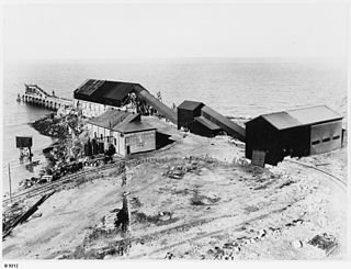
Klein Point is a headland in the Australian state of South Australia located about 7 kilometres south of Stansbury in the locality of Wool Bay on Yorke Peninsula. It is the site of a port facility established to handle shipments of limestone for Adelaide Brighton Cement. The port is managed by Flinders Ports. Prior to 1965 it was known as Farquhar Jetty.

Royston Island

Royston Island is an island in the Australian state of South Australia at the northern end of Pondalowie Bay on the south-west extremity of Yorke Peninsula about 13 kilometres north-west of the town of Stenhouse Bay. The island has enjoyed protected area status since 1967 and since 1972, it has been part of the Innes National Park.

South Island (South Australia)

South Island is an island located in the Australian state of South Australia at the south end of Pondalowie Bay on the south-west extremity of Yorke Peninsula about 11 kilometres north-west by west of the town of Stenhouse Bay. The island has enjoyed protected area status since 1970 and since 1977, it has been part of the Innes National Park.

Foul Bay, South Australia South Australia

Foul Bay is a locality in the Australian state of South Australia located on the south coast of Yorke Peninsula immediately adjoining Investigator Strait about 130 kilometres west of the state capital of Adelaide.

Nalyappa, South Australia Suburb of Yorke Peninsula Council , South Australia

Nalyappa is a locality in the Australian state of South Australia located on the west coast of Yorke Peninsula immediately adjoining Spencer Gulf about 128 kilometres north-west of the state capital of Adelaide.

Couch Beach, South Australia Suburb of Yorke Peninsula Council , South Australia

Couch Beach is a locality in the Australian state of South Australia located on the western side of Yorke Peninsula on the portion forming the south coast of Hardwicke Bay in Spencer Gulf about 130 kilometres west of the state capital of Adelaide.

The Pines, South Australia Suburb of Yorke Peninsula Council , South Australia

The Pines is a locality in the Australian state of South Australia located on the western side of Yorke Peninsula on the portion forming the south coast of Hardwicke Bay in Spencer Gulf about 131 kilometres west of the Adelaide city centre.

References