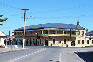
Yorketown is a town and a locality in the Australian state of South Australia located in the southern Yorke Peninsula about 91 kilometres (57 mi) west of the state capital of Adelaide and about 70 kilometres (43 mi) south of the municipal seat of Maitland. At the 2016 census, the locality had a population of 969 of which 642 lived in its town centre.
Corny Point is a locality in the Australian state of South Australia located about 7.5 kilometres to the east of the north-western tip of the Yorke Peninsula. It was named after the nearby headland, Corny Point. The first pastoral lease was taken up in 1846 by James Coutts.

Sultana Point is a locality in the Australian state of South Australia located on the Yorke Peninsula immediately adjoining the western head of Gulf St Vincent about 80 kilometres west of the state capital of Adelaide.
Wallaroo Plain is a locality in the Australian state of South Australia located on the west coast of Yorke Peninsula immediately adjoining Spencer Gulf about 148 kilometres north-west of the state capital of Adelaide.
Foul Bay is a locality in the Australian state of South Australia located on the south coast of Yorke Peninsula immediately adjoining Investigator Strait about 130 kilometres west of the state capital of Adelaide.
White Hut is a locality in the Australian state of South Australia. It is on the west coast of Yorke Peninsula immediately adjoining Spencer Gulf about 145 kilometres west of the state capital of Adelaide. Its boundaries were created in May 1999. As of 2014, the majority of the land within the locality is zoned as “water protection” to protect groundwater basins present at “shallow depths” and to encourage land use such as “broadacre cropping, grazing, and wind farm and ancillary development.” White Hut is within the federal division of Grey, the state electoral district of Narungga and the local government area of the Yorke Peninsula Council.

Dowlingville is a locality in the Australian state of South Australia located on the east coast of Yorke Peninsula immediately adjoining Gulf St Vincent about 89 kilometres north-west of the state capital of Adelaide. Its boundaries were created in May 1999.
Tiddy Widdy Beach is a locality in the Australian state of South Australia located on the east coast of Yorke Peninsula immediately adjoining Gulf St Vincent about 84 kilometres northwest of the Adelaide city centre and about 5 kilometres northeast of the centre of Ardrossan.

James Well is a locality in the Australian state of South Australia located on the east coast of Yorke Peninsula immediately adjoining Gulf St Vincent about 84 kilometres north-west of the state capital of Adelaide and about 5 kilometres of the centre of Ardrossan.
Rogues Point is a locality in the Australian state of South Australia located on the east coast of Yorke Peninsula immediately adjoining Gulf St Vincent, about 80 kilometres north-west of the Adelaide city centre and about 6.9 kilometres of the centre of Ardrossan.
Sheaoak Flat is a locality in South Australia located on the east coast of Yorke Peninsula immediately adjoining Gulf St Vincent about 71 kilometres north-west of the Adelaide city centre.
Sandilands is a locality in the Australian state of South Australia located on the east coast of Yorke Peninsula immediately adjoining Gulf St Vincent about 88 kilometres (55 mi) north-west of the state capital of Adelaide and about 18 kilometres (11 mi) south-east of the municipal seat in Maitland.
Nalyappa is a locality in the Australian state of South Australia located on the west coast of Yorke Peninsula immediately adjoining Spencer Gulf about 128 kilometres north-west of the state capital of Adelaide.
Chinaman Wells is a locality in the Australian state of South Australia located on the west coast of Yorke Peninsula immediately adjoining Spencer Gulf about 119 kilometres north-west of the state capital of Adelaide.
North Beach is a locality in South Australia located on the west coast of Yorke Peninsula immediately adjoining Spencer Gulf about 145 kilometres north-west of the Adelaide city centre.
Couch Beach is a locality in the Australian state of South Australia located on the western side of Yorke Peninsula on the portion forming the south coast of Hardwicke Bay in Spencer Gulf about 130 kilometres west of the state capital of Adelaide.
The Pines is a locality in the Australian state of South Australia located on the western side of Yorke Peninsula on the portion forming the south coast of Hardwicke Bay in Spencer Gulf about 131 kilometres west of the Adelaide city centre.
Point Souttar is a locality in the Australian state of South Australia located on the western side of Yorke Peninsula on the portion forming the south coast of Hardwicke Bay in Spencer Gulf about 121 kilometres west of the Adelaide city centre.

Port Julia is a locality in the Australian state of South Australia located on the east coast of Yorke Peninsula about 72 kilometres northwest of the Adelaide city centre.
Bluff Beach is a locality in the Australian state of South Australia located on the west coast of Yorke Peninsula overlooking Hardwicke Bay about 104 kilometres west of the state capital of Adelaide.
