| Barker Inlet-St Kilda Aquatic Reserve South Australia | |
|---|---|
IUCN category VI (protected area with sustainable use of natural resources) | |
 Barker Inlet-St Kilda Aquatic Reserve | |
| Nearest town or city | Port Adelaide. |
| Coordinates | 34°47′01″S138°32′43″E / 34.7836°S 138.5454°E Coordinates: 34°47′01″S138°32′43″E / 34.7836°S 138.5454°E |
| Established | 23 August 1973 [1] |
| Area | 29.60 km2 (11.4 sq mi) [2] |
| Managing authorities | Primary Industries and Resources South Australia (PIRSA) |
| Footnotes | Coordinates [2] Nearest town [3] |
| See also | Protected areas of South Australia |
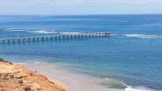
Barker Inlet-St Kilda Aquatic Reserve is a marine protected area in the Australian state of South Australia located in waters adjoining the east coast of Gulf St Vincent in Barker Inlet about 16 kilometres (9.9 mi) north of the state capital of Adelaide. [3] [4]
Marine protected areas (MPA) are protected areas of seas, oceans, estuaries or large lakes. These marine areas can come in many forms ranging from wildlife refuges to research facilities. MPAs restrict human activity for a conservation purpose, typically to protect natural or cultural resources. Such marine resources are protected by local, state, territorial, native, regional, national, or international authorities and differ substantially among and between nations. This variation includes different limitations on development, fishing practices, fishing seasons and catch limits, moorings and bans on removing or disrupting marine life. In some situations, MPAs also provide revenue for countries, potentially equal to the income that they would have if they were to grant companies permissions to fish.

South Australia is a state in the southern central part of Australia. It covers some of the most arid parts of the country. With a total land area of 983,482 square kilometres (379,725 sq mi), it is the fourth-largest of Australia's states and territories by area, and fifth largest by population. It has a total of 1.7 million people, and its population is the second most highly centralised in Australia, after Western Australia, with more than 77 percent of South Australians living in the capital, Adelaide, or its environs. Other population centres in the state are relatively small; Mount Gambier, the second largest centre, has a population of 28,684.

Gulf St Vincent is a large inlet of water on the southern coast of Australia, in the state of South Australia. It is bordered by Yorke Peninsula on its west, the mainland and Fleurieu Peninsula to its east, with its entrance being a line from Troubridge Point on Yorke Peninsula to Cape Jervis on Fleurieu Peninsula.
Contents
The aquatic reserve covers the extent of the Barker Inlet located to the south of the St Kilda boat channel as well as two natural channels, the Angas Inlet and the east part of the North Arm, and land subject to tidal inundation on the east side of Torrens Island, all sides of Garden Island and in the suburbs of Gillman, Dry Creek, Bolivar and St Kilda (from west to east). It is bounded to its immediate north by the St Kilda – Chapman Creek Aquatic Reserve. [5] [3] [4]

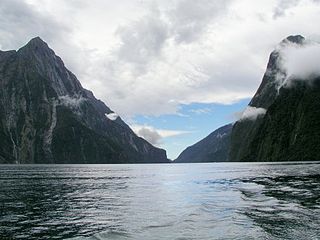
The Barker Inlet is a tidal inlet of the Gulf St Vincent in Adelaide, South Australia, named after Captain Collet Barker who first sighted it in 1831. It contains one of the southernmost mangrove forests in the world, a dolphin sanctuary, seagrass meadows and is an important fish and shellfish breeding ground. The inlet separates Torrens Island and Garden Island from the mainland to the East and is characterized by a network of tidal creeks, artificially deepened channels, and wide mudflats. The extensive belt of mangroves are bordered by samphire saltmarsh flats and low-lying sand dunes, there are two boardwalks, and ships graveyards in Broad Creek, Angas Inlet and the North Arm.
Torrens Island is an island in the Australian state of South Australia located in the Port River Estuary between the Port River and Barker Inlet, about 15 kilometres (9.3 mi) northwest of the state capital of Adelaide. Since European settlement of Adelaide in 1836, it has been used for a number of purposes.

Garden Island is an island in the Australian state of South Australia located about 14 kilometres (8.7 mi) north-west of the capital city of Adelaide in an estuary system within the Adelaide metropolitan area which drains into Gulf St Vincent. It is notable as being a site for a mangrove forest, a landfill, a part of the site for the Multifunction Polis, a ship graveyard and a venue for recreational boating activities. It has enjoyed varying degrees of protected area status since 1973.
It was declared on 23 August 1973 for the purpose of “conservation of mangrove seagrass communities and for the protection of nursery areas for several important commercial and recreational species, including the western king prawn, King George whiting, yellowfin whiting and blue swimmer crabs for fisheries management.” The following activities are permitted - boating, the removal of fish by rod and line or handline and the collecting of blood worms for bait by use of a hand net. [4] [1]
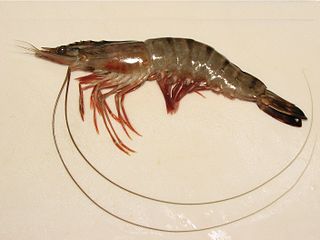
Penaeus is a genus of Papus, including the giant tiger prawn, the most important species of farmed crustacean worldwide. The genus has been reorganised following a proposition of Pérez Farfante and Kensley based on morphological differences, in particular the genital characteristics of these animals, although this revision has not been universally accepted. Following the revision, many species formerly in the genus Penaeus have been reassigned to new genera in the family Penaeidae: Farfantepenaeus, Fenneropenaeus, Litopenaeus and Marsupenaeus. The following table gives an overview:

The King George whiting, also known as the spotted whiting or spotted sillago, is a coastal marine fish of the smelt-whitings family Sillaginidae. The King George whiting is endemic to Australia, inhabiting the south coast of the country from Jurien Bay, Western Australia to Botany Bay, New South Wales in the east. The King George whiting is the only member of the genus Sillaginodes and the largest member of the smelt-whiting family Sillaginidae, growing to a length of 72 cm and 4.8 kg in weight. The species is readily distinguishable from other Australian whitings by its unique pattern of spots, as well as its highly elongate shape. King George whiting are often found in bays and protected waterways over sand and seagrass beds, also venturing out onto deep continental shelf reefs during adulthood. The species is a benthic carnivore, consuming a variety of crustaceans, polychaete worms, molluscs and fish. The King George whiting forms the basis of one of southern Australia's most important commercial fisheries, reportedly worth over five million Australian dollars per year. The species is also heavily targeted by recreational anglers, who value the whiting for its sporting and eating qualities.

The yellowfin whiting, Sillago schomburgkii, is a species of inshore marine fish in the smelt-whiting family Sillaginidae. The species is endemic to the eastern Indian Ocean, ranging from Dampier, Western Australia to Gulf St Vincent in South Australia, with an apparent division in the populations of the two states. Yellowfin whiting inhabit relatively shallow waters for their entire life, often found on tidal flats and creeks, as well as large estuaries. It is one of the largest members of the smelt-whiting family, growing to 42 cm, and can be distinguished by a number of anatomical and colour related features. Yellowfin whiting are benthic carnivores, preying predominantly on polychaete worms, with minor amounts of copepods, amphipods and bivalves also commonly taken. The species shows a change in diet with age, and also dietary differences with other sillaginids presumably to minimize competition. Reproduction occurs at different times throughout its range, generally focused around summer, with up to 217,000 eggs produced per season. Yellowfin whiting reach sexual maturity at around 20 cm, with each individual spawning more than once. The species forms the basis of major fisheries in both Shark Bay, Western Australia and the two Gulfs of South Australia, with around 260 tonnes of fish taken each year. They are also a popular target for shore based anglers, with a reputation as a very good table fish.
It shares territory with the following protected and proposed protected areas - the Adelaide Dolphin Sanctuary, the Adelaide International Bird Sanctuary and the Torrens Island Conservation Park. [3] [5]

Adelaide Dolphin Sanctuary is a marine protected area in the Australian state of South Australia located on the east coast of Gulf St Vincent in and adjoining the north-western part of the Adelaide metropolitan area and which was established in 2005 for the protection of a resident population of Indo-Pacific bottlenose dolphins .

Torrens Island Conservation Park is a protected area in the Australian state of South Australia located on Torrens Island in the Adelaide metropolitan area about 17 kilometres north-northwest of the state capital of Adelaide and about 3.9 kilometres north-northeast of Port Adelaide.
The aquatic reserve is classified as an IUCN Category VI protected area. [2]
The International Union for Conservation of Nature is an international organization working in the field of nature conservation and sustainable use of natural resources. It is involved in data gathering and analysis, research, field projects, advocacy, and education. IUCN's mission is to "influence, encourage and assist societies throughout the world to conserve nature and to ensure that any use of natural resources is equitable and ecologically sustainable".