Goobang is a national park located in New South Wales, Australia, 296 kilometres (184 mi) northwest of Sydney. It protects the largest remnant forest and woodland in the central west region of the state, where interior and coastal New South Wales flora and fauna species overlap. Originally named Herveys Range by John Oxley in 1817, the area was reserved in 1897 as state forest because of its importance as a timber resource, and was designated a national park in 1995.

The South Bruny National Park is a national park located on Bruny Island, Tasmania, Australia, about 50 kilometres (31 mi) south of Hobart. The park contains the Cape Bruny Lighthouse. The highest point of the park is Mount Bruny at 504 metres (1,654 ft).

Pardalotes or peep-wrens are a family, Pardalotidae, of very small, brightly coloured birds native to Australia, with short tails, strong legs, and stubby blunt beaks. This family is composed of four species in one genus, Pardalotus, and several subspecies. The name derives from a Greek word meaning "spotted". The family once contained several other species now split into the family Acanthizidae.

The common brushtail possum is a nocturnal, semiarboreal marsupial of the family Phalangeridae, native to Australia and invasive in New Zealand, and the second-largest of the possums.
Bush regeneration, a form of natural area restoration, is the term used in Australia for the ecological restoration of remnant vegetation areas, such as through the minimisation of negative disturbances, both exogenous such as exotic weeds and endogenous such as erosion. It may also attempt to recreate conditions of pre-European arrival, for example by simulating endogenous disturbances such as fire. Bush regeneration attempts to protect and enhance the floral biodiversity in an area by providing conditions conducive to the recruitment and survival of native plants.
Puckey's Estate Reserve is a coastal nature reserve in North Wollongong, New South Wales, Australia. It is mainly she-oak forest, but also has sand dune and wetland areas, including areas along Para Creek. It is located in the suburb of Fairy Meadow and is bounded by Fairy Meadow Beach to the east, Squires Way to the west, Elliotts Road to the north and Fairy Lagoon to the south.

Enfield is a suburb in Adelaide, Australia. The suburb is about a 10-minute drive north from Adelaide city centre. The suburb is bordered by Gepps Cross to the north, Blair Athol to the west, Clearview to the east, and Prospect, Sefton Park and Broadview to the south.
Clearview is a suburb of Adelaide, South Australia about 8 km north of the Adelaide city centre. The rectangular suburb is bordered by Grand Junction Road on the north, Hampstead Road on the east, Collins Street, Broadview on the south, and the suburb of Enfield on the west.

Totness Recreation Park is a protected area in the Australian state of South Australia located within the localities of Mount Barker and Totness in the central Mount Lofty Ranges. Covering 41 hectares of land, the park is divided by the South Eastern Freeway and features a large dam. It was declared as a reserve in 1970 and re-designated as a recreation park in 1972. The park has no visitor facilities except for access tracks. It is the only park in the district, managed by the Department of Environment and Water, that is solely designated for recreation.
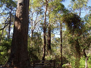
Jarrah Forest, also known as the Southwest Australia woodlands, is an interim Australian bioregion and ecoregion located in the south west of Western Australia. The name of the bioregion refers to the region's dominant plant community, jarrah forest – a tall, open forest in which the dominant overstory tree is jarrah.
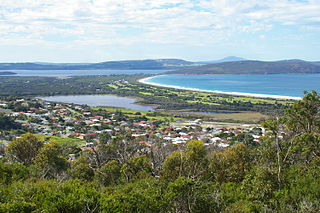
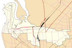
Lake Seppings is a freshwater lake located within the city of Albany in the Great Southern region of Western Australia.

The Ulandra Nature Reserve is a protected nature reserve that is located in the west hills of the Southern Tablelands and eastern Riverina regions of New South Wales in eastern Australia. The 3,930-hectare (9,700-acre) reserve is situated approximately 25 kilometres (16 mi) south-west of Cootamundra and 4 kilometres (2.5 mi) south-east of the village of Bethungra.

Anstey Hill Recreation Park is a 362-hectare (890-acre) protected area established in 1989 and located approximately 19 kilometres (12 mi) northeast of Adelaide, South Australia. The park is a significant reserve of bushland in the foothills of the Mount Lofty Ranges and is home to rare or vulnerable native plants and animals, and problematic invasive species. It is managed by the City of Tea Tree Gully, the Department of Environment, Water and Natural Resources and a volunteer group—The Friends of Anstey Hill. The park is designed for recreational walking and has no visitor facilities. It is managed in association with the regional planning initiative known as of Yurrebilla, the Greater Mount Lofty Parklands.

The Moorooduc Quarry Flora and Fauna Reserve is located in Mount Eliza, Victoria, Australia and occupies approximately 27 hectares of land. There are entrances to the reserve located on Allison Road, Canadian Bay Road, Two Bays Road and Station Street near the Moorooduc Railway Station.

Lane Cove Bushland Park is located in suburban Lane Cove, 5 kilometres from the centre of Sydney, Australia. It is regarded as one of the more interesting areas of fungi in the country. In the year 2000, Bushland Park was placed on the Register of the National Estate, under the Australian Heritage Commission Act, 1975. Average annual rainfall is 1220 mm. Soils are moderately fertile, based on Hawkesbury sandstone and Ashfield Shale. The climate is warm and humid.
The Peter Murrell Conservation Area is located in Huntingfield, Tasmania, approximately 15 km (9.3 mi) south of the state's capital city, Hobart. The conservation area has an area of 135 ha and is one of three reserves within the Peter Murrell Reserves. Also within these reserves are the Peter Murrell State Reserve and a Public Reserve. These reserves and the Conservation Area lie at the base of the Tinderbox Peninsula, between the suburbs of Kingston, Howden and Blackman's Bay. The Peter Murrell Conservation Area surrounds the northern, western and southern sides of the Peter Murrell State Reserve.

Ferndale Park is located in suburban Chatswood, 8 km (5 mi) from the centre of Sydney, Australia. It is an important urban forest reserve, preserving Blackbutt forest and the mossy gully rainforest. Most of this original forest was cleared for agriculture and housing in the 19th and 20th century.

Caravan Head Bushland Reserve is a reserve approximately 2.2ha located in Sutherland Shire, southern Sydney, in the state of New South Wales, Australia.

Wetherill Park Nature Reserve, also called Wetherill Park Reserve, is an urban park and a nature reserve situated in the western suburbs of Sydney, New South Wales, Australia. The reserve contains an open woodland and bushland which feature native plants, such as eucalyptus trees, and recreational areas.
Cromer Conservation Park is a protected area located in the Australian state of South Australia in the locality of Cromer in the Adelaide Hills state government region about 38 kilometres (24 mi) north-east of the state capital of Adelaide and about 4 kilometres (2.5 mi) north of the town centre in Birdwood.