Vasse-Wonnerup Estuary

Last updated

Designations
Official nameVasse-Wonnerup System
Designated7 June 1990
Reference no.484 [1]
Vasse-Wonnerup Estuary Wetlands near Busselton BSN Wetlands20A.jpg
Vasse-Wonnerup Estuary Wetlands near Busselton

The Vasse-Wonnerup Estuary is an estuary in the South West region of Western Australia close to the town of Busselton. The estuary is listed with DIWA. [2] It was also recognised as a wetland of international importance under the Ramsar Convention on 7 June 1990 when an area of 1,115 ha (2,760 acres) was designated Ramsar Site 484 as an important dry-season habitat for waterbirds. [3] It is also the main part of the 2,038 ha (5,040 acres) Busselton Wetlands Important Bird Area. [4]

Estuary A partially enclosed coastal body of brackish water with one or more rivers or streams flowing into it, and with a free connection to the open sea

An estuary is a partially enclosed coastal body of brackish water with one or more rivers or streams flowing into it, and with a free connection to the open sea.

South West (Western Australia) Place in Western Australia, Australia

The South West region is one of the nine regions of Western Australia. It is so named because it is located in the south-west corner of Western Australia. The South West region has an area of 23,970 km², and a population of about 170,000 people, which is predicted to rise to 217,000 people by 2023.

Western Australia state in Australia

Western Australia is a state occupying the entire western third of Australia. It is bounded by the Indian Ocean to the north and west, and the Southern Ocean to the south, the Northern Territory to the north-east, and South Australia to the south-east. Western Australia is Australia's largest state, with a total land area of 2,529,875 square kilometres, and the second-largest country subdivision in the world, surpassed only by Russia's Sakha Republic. The state has about 2.6 million inhabitants – around 11 percent of the national total – of whom the vast majority live in the south-west corner, 79 per cent of the population living in the Perth area, leaving the remainder of the state sparsely populated.

Contents

Description

The estuary is wave dominated and has been severely modified from its natural state. The site of the Vasse and Wonnerup Floodgates that regulated the flow of water in the estuary from about 1907 inadvertently created the freshwater wetland, were listed on the Western Australian Register of Heritage Places in 2005. [5] The estuary covers a total surface area of 17.8 square kilometres (7 sq mi) with the central basin having an area of 7.5 square kilometres (3 sq mi) [6] In winter, wide areas of open water are fringed by samphire and rushes. Paperbark woodland occurs behind the samphire belt, with eucalypt woodland on higher ground.

Vasse and Wonnerup Floodgates

The Vasse and Wonnerup Floodgates is a heritage listed site in Western Australia that comprises two locations. The two locations are the site of the Vasse floodgates on the Vasse River and the Wonnerup floodgates on the Wonnerup Estuary. In addition, the 2004 site of the Vasse floodgates was also the site of the Ballarat Bridge which was built in 1871 as part of a logging rail line where the Ballarat Steam engine was the first steam engine to operate in Western Australia.

Samphire

Samphire is a name given to a number of succulent halophytes that tend to be associated with water bodies.

Juncaceae family of plants

Juncaceae is a family of flowering plants, commonly known as the rush family. It consists of 8 genera and about 464 known species of slow-growing, rhizomatous, herbaceous monocotyledonous plants that may superficially resemble grasses and sedges. They often grow on infertile soils in a wide range of moisture conditions. The best-known and largest genus is Juncus. Most of the Juncus species grow exclusively in wetland habitats. A few rushes, such as Juncus bufonius are annuals, but most are perennials.

Catchment

The catchment of the estuary is 52% cleared and is used primarily for crops and pastures but also for plantations. The waters are susceptible to pollution from run-off as houses in Busselton have been built adjacent to the estuary. The Abba River, Ludlow River, Sabina River and Vasse River all discharge into the estuary.

The Abba River is a river in the South West of Western Australia.

The Ludlow River is a river in the South West region of Western Australia. It was named after Frank Ludlow, one of the first Western Australian colonists, an arrival on the barque Parmelia in 1829, who explored the locality in 1834.

The Sabina River is a river in the South West of Western Australia.

The catchment covers a total area of 961 square kilometres (371 sq mi) and is part of the Geographe Bay catchment. The coastal plain area is composed of sandy and duplex soils that are easily water-logged. An extensive drainage network has been constructed to protect Busselton and Wonnerup from flooding and to create agricultural land. [7]

Geographe Bay bay

Geographe Bay is in the south-west of Western Australia around 220 km southwest of Perth.

Wonnerup, Western Australia Town in Western Australia

The townsite of Wonnerup is located 219 kilometres (136 mi) south of Perth and 10 kilometres (6 mi) east of Busselton. It was gazetted a townsite in 1856, deriving its name from the nearby Wonnerup Inlet.

Birds

It is estimated that over 20,000 waterbirds use the estuary as habitat with over 80 species of waterbird being found. Some of the species found in the area include black-winged stilt, banded stilt, Australasian shoveller, Australian shelduck and the red-necked avocet. The largest breeding colony of black swans in Western Australia (over 150 pairs) is in the estuary. [4] [8]

Black-winged stilt species of bird

The black-winged stilt is a widely distributed very long-legged wader in the avocet and stilt family (Recurvirostridae). The scientific name H. himantopus was formerly applied to a single, almost cosmopolitan species. It is now normally applied to the form that is widespread in Eurasia and Africa and which was formerly regarded as the nominate subspecies of Himantopus himantopussensu lato. The scientific name Himantopus comes from the Greek meaning "strap foot" or "thong foot". Most sources today accept 2–4 species. It is sometimes called pied stilt, but that name is now reserved for the Australian species, Himantopus leucocephalus.

Banded stilt A nomadic wading bird of the stilt and avocet family Recurvirostridae native to Australia.

The banded stilt is a nomadic wader of the stilt and avocet family, Recurvirostridae, native to Australia. It belongs to the monotypic genus Cladorhynchus. It gets its name from the red-brown breast band found on breeding adults, though this is mottled or entirely absent in non-breeding adults and juveniles. Its remaining plumage is pied and the eyes are dark brown. Nestling banded stilts have white down, unlike any other species of wader.

Australian shelduck species of bird

The Australian shelduck, also known as the chestnut-breasted shelduck or mountain duck, is a shelduck part of the bird family Anatidae. The genus name Tadorna comes from Celtic roots and means "pied waterfowl". They are protected under the National Parks and Wildlife Act, 1974.

Fish kills

Fish kills have occurred in the estuary in 2009, 2011 and 2013. In the 2013 event an estimated 7,000 fish died over the course of two days, calling into question the health of the waterway. It is thought that low flows, poor water quality and high phosphorus levels were to blame. Rainfall washed nutrients downstream to the estuary then a warm spell sparked the growth of algae depleting the water of oxygen, killing the fish. [9]

Fish kill localized die-off of fish populations

The term fish kill, known also as fish die-off, refers to a localized die-off of fish populations which may also be associated with more generalized mortality of aquatic life. The most common cause is reduced oxygen in the water, which in turn may be due to factors such as drought, algae bloom, overpopulation, or a sustained increase in water temperature. Infectious diseases and parasites can also lead to fish kill. Toxicity is a real but far less common cause of fish kill.

Phosphorus Chemical element with atomic number 15

Phosphorus is a chemical element with symbol P and atomic number 15. Elemental phosphorus exists in two major forms, white phosphorus and red phosphorus, but because it is highly reactive, phosphorus is never found as a free element on Earth. It has a concentration in the Earth's crust of about one gram per kilogram. With few exceptions, minerals containing phosphorus are in the maximally oxidized state as inorganic phosphate rocks.

Algae Group of eukaryotic organisms

Algae is an informal term for a large, diverse group of photosynthetic eukaryotic organisms that are not necessarily closely related, and is thus polyphyletic. Including organisms ranging from unicellular microalgae genera, such as Chlorella and the diatoms, to multicellular forms, such as the giant kelp, a large brown alga which may grow up to 50 m in length. Most are aquatic and autotrophic and lack many of the distinct cell and tissue types, such as stomata, xylem, and phloem, which are found in land plants. The largest and most complex marine algae are called seaweeds, while the most complex freshwater forms are the Charophyta, a division of green algae which includes, for example, Spirogyra and the stoneworts.

Related Research Articles

Lake Corangamite lake in Victoria, Australia

Lake Corangamite, a hypersaline endorheic lake, is located near Colac in the Lakes and Craters region of the Victorian Volcanic Plains of south-west Victoria, Australia. The lake's salinity levels have increased dramatically as the lake level has dropped in recent decades. It is Australia's largest permanent saline lake, covering approximately 230 square kilometres (89 sq mi) with a circumference of 150 kilometres (93 mi). It forms part of the Ramsar-listed Western District Lakes wetland site.

Blackwood River river and catchment in Western Australia, Australia

The Blackwood River is a major river and catchment in the South West of Western Australia.

The Peel-Harvey Estuarine System is a natural estuarine system that lies roughly parallel to the coast of Western Australia and south of the town of Mandurah. The strip of land between the Indian Ocean and the estuarine system carries the Old Coast Road and to the east is the Forrest Highway which is the main thoroughfare between Perth and the coastal towns of the south west corner of the state including Bunbury and Busselton.

Leschenault Estuary

Leschenault Estuary is an estuarine lagoon that lies to the north of Bunbury, Western Australia. It had in the past met the Indian Ocean at the Leschenault Inlet, but that has been altered by harbour works for Bunbury, and the creation of The Cut north of the historical inlet location.

Lake Connewarre lake in Victoria, Australia

Lake Connewarre, a shallow estuarine 880-hectare (2,200-acre) lake on the Barwon River, is located on the Bellarine Peninsula southeast of Geelong in the Australian state of Victoria.

Vasse River river in Western Australia, Australia

The Vasse River is a river in the South West of Western Australia.

Lake Warden (Western Australia) lake in Australia

Lake Warden is a salt lake in the Goldfields-Esperance region of Western Australia. It and its associated wetlands are protected in a nature reserve; they were recognised as being of international importance under the Ramsar Convention through designation of the Lake Warden System on 7 June 1990 as Ramsar Site 485. The lake is also a DIWA-listed wetland.

Lake Gore Australian freshwater lake

Lake Gore is a seasonal and semi-permanent freshwater lake in the Goldfields-Esperance region of Western Australia located approximately 24 km (15 mi) west of Esperance. It is an important site for waterbirds.

Reedy Lake lake in Victoria, Australia

Reedy Lake, historically also known as Lake Reedy, is a shallow 5.5-square-kilometre (2.1 sq mi) intermittent freshwater lake or swamp on the lower reaches of the Barwon River, on the Bellarine Peninsula southeast of Geelong in the Australian state of Victoria.

The Port Phillip Bay and Bellarine Peninsula Ramsar Site is one of the Australian sites listed under the Ramsar Convention as a wetland of international importance. It was designated on 15 December 1982, and is listed as Ramsar Site No.266. Much of the site is also part of either the Swan Bay and Port Phillip Bay Islands Important Bird Area or the Werribee and Avalon Important Bird Area, identified as such by BirdLife International because of their importance for wetland and waterbirds as well as for orange-bellied parrots. It comprises some six disjunct, largely coastal, areas of land, totalling 229 km2, along the western shore of Port Phillip and on the Bellarine Peninsula, in the state of Victoria. Wetland types protected include shallow marine waters, estuaries, freshwater lakes, seasonal swamps, intertidal mudflats and seagrass beds.

Thomsons Lake is a lake nature reserve in the City of Cockburn, Western Australia, approximately 25 kilometres (16 mi) south of the central business district of Perth, the state capital, and on the southern fringes of the Perth metropolitan area. It in the suburb of Beeliar, 7 kilometres (4.3 mi) south-west of Jandakot Airport. It is a still largely natural wetland, with adjoining native vegetation, surrounded by land developed for housing and agriculture, that regularly supports large numbers of shorebirds and other waterbirds.

The Forrestdale and Thomsons Lakes Ramsar Site comprises two separate nature reserves, totaling 754 ha in area, protecting two shallow fresh to brackish, seasonal lakes in a suburban and agricultural landscape in south-western Western Australia. It is used mainly for birdwatching and walking. It lies in the Swan Coastal Plain bioregion. The site is recognised as being of international importance under the Ramsar Convention on Wetlands, under which it was designated Ramsar Site 481 on 7 June 1990.

Moulting Lagoon Important Bird Area lake in Australia

Moulting Lagoon Important Bird Area is a composite wetland site in eastern Tasmania, Australia. It comprises two adjacent and hydrologically continuous wetlands – Moulting Lagoon and the Apsley Marshes – at the head of Great Oyster Bay, near the base of the Freycinet Peninsula, between the towns of Swansea and Bicheno. Both components of the site are listed separately under the Ramsar Convention as wetlands of international significance. Moulting Lagoon is so named because it is a traditional moulting place for black swans. It is an important site for waterbirds.

Paroo Floodplain and Currawinya Important Bird Area Important Bird Area in New South Wales, Australia

The Paroo Floodplain and Currawinya Important Bird Area is a 7,874 km2 (3,040 sq mi) site comprising the floodplain and the associated wetlands of the Paroo River in north-western New South Wales and south-western Queensland, Australia. It includes extensive areas of the Paroo-Darling and Currawinya National Parks, both of which are listed under the Ramsar Convention as wetland sites of international importance, as well as of the Nocoleche Nature Reserve.

Yalgorup Important Bird Area

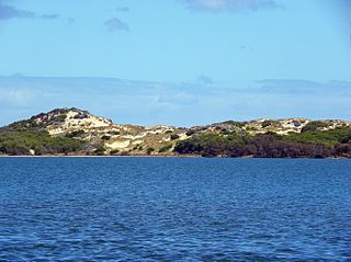
The Yalgorup Important Bird Area comprises a group of parallel, linear wetlands, with a collective area of 59 km2, on the Swan Coastal Plain of south-west Western Australia between the cities of Mandurah and Bunbury. It is an important site for waterbirds.

References

  1. "Vasse-Wonnerup System". Ramsar Sites Information Service. Retrieved 25 April 2018.
  2. "Swan Coastal Plain 2 (SWA2 – Swan Coastal Plain subregion)" (PDF). 2002. Retrieved 2009-04-16.
  3. "Information Sheet on Ramsar Wetlands (RIS) - Vasse-Wonnerup System, Western Australia - 38". 2003. Retrieved 2009-04-16.
  4. 1 2 "IBA: Busselton Wetlands". Birdata. Birds Australia. Retrieved 2011-06-08.
  5. Heritage Council (1 January 2017). "Site of Ballarat Bridge, Vasse Floodgates & Wonnerup Floodgates". State Heritage Council, Government of Western Australia. Retrieved 20 December 2018.
  6. "Estuary Assessment Framework for Non-Pristine Estuaries - Estuary 651 - Vasse-Wonnerup". 2007. Retrieved 2009-04-16.
  7. "Aggregated nutrient emissions to the WA Vasse-Wonnerup water catchment report". 2004. Retrieved 2009-04-16.
  8. "Caring for our Country priority coastal hotspots". 2008. Retrieved 2010-10-15.
  9. "Another fish kill stinks out Wonnerup". Australian Broadcasting Corporation. 16 April 2013. Retrieved 27 April 2013.

Coordinates: 33°38′S115°24′E / 33.633°S 115.400°E / -33.633; 115.400