Related Research Articles

The Murrumbidgee River is a major tributary of the Murray River within the Murray–Darling basin and the second longest river in Australia. It flows through the Australian state of New South Wales and the Australian Capital Territory, descending 1,500 metres (4,900 ft) over 1,485 kilometres (923 mi), generally in a west-northwesterly direction from the foot of Peppercorn Hill in the Fiery Range of the Snowy Mountains towards its confluence with the Murray River near Boundary Bend.

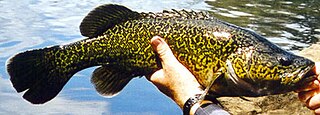
The Murray cod is a large Australian predatory freshwater fish of the genus Maccullochella in the family Percichthyidae. Although the species is called a cod in the vernacular, it is not related to the Northern Hemisphere marine cod (Gadus) species. The Murray cod is an important part of Australia's vertebrate wildlife—as an apex predator in the Murray-Darling River system—and also significant in Australia's human culture. The Murray cod is the largest exclusively freshwater fish in Australia, and one of the largest in the world. Other common names for Murray cod include cod, greenfish, goodoo, Mary River cod, Murray perch, ponde, pondi and Queensland freshwater cod.
The eastern freshwater cod, also known as the eastern cod or Clarence River cod, is a large predatory freshwater fish of the genus Maccullochella and the family Percichthyidae, that occur in the coastal Clarence River system of north-eastern New South Wales. Eastern freshwater cod are closely related to the Murray cod of the Murray-Darling River system, and are considered an icon of the Clarence River system.

The Molonglo River, a perennial river that is part of the Murrumbidgee catchment within the Murray–Darling basin, is located in the Monaro and Capital Country regions of New South Wales and the Australian Capital Territory, in Australia.

The Macquarie Marshes Nature Reserve is a protected natural wetland reserve that is located within the Macquarie Marshes, in the region along the lower Macquarie River in northwestern New South Wales, Australia. The 19,824-hectare (48,990-acre) reserve is situated approximately 600 kilometres (370 mi) northwest of Sydney and 100 kilometres (62 mi) north of Warren.

The golden perch is a medium-sized, yellow or gold-coloured species of Australian freshwater fish found primarily in the Murray-Darling River system, though a subspecies is found in the Lake Eyre-Cooper Creek system, and another subspecies, suspected to be ancestral to all other populations, is found in the Fitzroy River system in Queensland. Other common names for golden perch are "goldens", “yellowbelly” and "callop", the last generally used only in South Australia.

The Towra Point Nature Reserve is a protected nature reserve that is located in Sutherland Shire, southern Sydney, New South Wales, in eastern Australia. The 603-hectare (1,490-acre) reserve is situated on the southern shores of Botany Bay at Kurnell, within the Sutherland Shire. The reserve is protected under the Ramsar Convention as a wetland of international importance as an important breeding ground for many vulnerable, protected, or endangered species. The Towra Point Aquatic Nature Reserve is located in the surrounding waterways.
The Brisbane River cod was a unique form of Maccullochella cod that occurred naturally in the Brisbane River system, an east coast river system in south east Queensland, Australia. The Brisbane River Cod was known as the Bumgur by the Jinibara people centred in the Kilcoy region and the junction of the Stanley and Brisbane Rivers. Their exact taxonomic status is not known, but based on several genetic studies it is suspected that Brisbane River Cod were a species intermediate between eastern freshwater cod of the Clarence River and Richmond River systems in northern New South Wales and Mary River cod of the Mary River in central Queensland.

The silver perch is a medium-sized freshwater fish of the family Terapontidae endemic to the Murray-Darling river system in south-eastern Australia.

The Hadejia-Nguru wetlands in Yobe State in northern Nigeria, which include Nguru Lake, are ecologically and economically important. They are threatened by reduced rainfall in recent years, a growing population and upstream dam construction.
Scottsdale Reserve is a 1,328-hectare (3,280-acre) nature reserve on the Murrumbidgee River in south-central New South Wales, Australia. It is 79 kilometres (49 mi) south of Canberra, and 4 kilometres (2.5 mi) north of Bredbo. It is owned and managed by Bush Heritage Australia (BHA), which purchased it in 2006. The purchase was supportive of projects aiming to connect existing fragmented remnant habitat such as K2C. Since the 1870s up until 2006, the land was used for agriculture – primarily sheep grazing with some minor cropping. A significant component of the Reserve has been cleared of native vegetation.

The Barmah National Park, formerly Barmah State Park, is a national park located in the Hume region of the Australian state of Victoria. The park is located adjacent to the Murray River near the town of Barmah, approximately 225 kilometres (140 mi) north of Melbourne. The park consists of river red gum floodplain forest, interspersed with treeless freshwater marshes. The area is subject to seasonal flooding from natural and irrigation water flows.

The Yanga National Park is a newly formed national park, located near the township of Balranald in south- western New South Wales. It covers an area of 66,734 hectares which includes 1,932 hectares of Yanga Nature Reserve, and has a frontage of 170 kilometres (110 mi) on the Murrumbidgee River. It is largely located in the Lower Murrumbidgee Floodplain, which is included on A Directory of Important Wetlands in Australia because of its importance as a breeding site for waterbirds when flooded.
Toolibin Lake is a seasonal fresh to brackish water perched lake or wooded swamp, in south-western Australia. The lake is contained with a 493-hectare (1,218-acre) nature reserve and it is located about 200 kilometres (124 mi) south-east of Perth, in the Shire of Narrogin, and 40 kilometres (25 mi) east of the town of Narrogin, in the Wheatbelt region of Western Australia. The lake is listed by the Australian Government as a threatened ecological community under the Environment Protection and Biodiversity Conservation Act 1999.
Fivebough and Tuckerbil Wetlands are two wetland sites within the Riverina and Murrumbidgee Irrigation Area (MIA), near Leeton in New South Wales, Australia. Both Fivebough and Tuckerbil sites form Crown reserve number 1030008 managed by NSW Department of Industry, for ecological conservation and public recreation. The reserve was recognised as being a Wetland of International Importance through designation under the Ramsar Convention on 21 October 2002 as Ramsar Site 1224
The Narran Wetlands, also known as the Narran Lakes, contained within the Narran Lake Nature Reserve, comprise a series of protected ephemeral lakes and swamps fed by the Narran River in the north-west of New South Wales, Australia. The 26,480-hectare (65,400-acre) reserve is located approximately 50 kilometres (31 mi) east of Brewarrina.
The North Victorian Wetlands, also known as the Kerang Wetlands, comprise an extensive series of over 100 freshwater, brackish and saline lakes and swamps on the floodplain of the Loddon River where it enters the Murray valley, in the vicinity of the town of Kerang, in northern Victoria, south-eastern Australia. They are important for a variety, and sometimes large numbers, of waterbirds.

The Dharawal National Park is a protected national park that is located in the Illawarra region of New South Wales, in eastern Australia. The 6,508-hectare (16,080-acre) national park is situated between the Illawarra Range and the Georges River and is approximately 45 kilometres (28 mi) south west of Sydney. There are three entry points to the park: from the east through Darkes Forest; from the north through Wedderburn; and from the south through Appin.

Pseudoraphis spinescens, called spiny mudgrass or Moira grass is a rhizomatous and stoloniferous aquatic or semi-aquatic perennial grass, with ascending stems forming loose, floating mats in water to 1 m deep or more, or with stems to 50 cm high when not submerged. Moira grass was first described in 1810 by Robert Brown as Panicum spinescens, and subsequently transferred to Pseudoraphis by Joyce W. Vickery in 1950.
The Cumbung Swamp, also known as the Great Cumbung Swamp, is a wetland made up of the ecosystems surrounding the junction of the Murrumbidgee and Lachlan Rivers in the South West Region of New South Wales. When it is at full capacity, the swamp supports a large population of migratory waterbirds as well as one of the largest reed swamps in the Murray Darling Basin.
References
- ↑ "NSW Central Murray State Forests". Ramsar Sites Information Service. Retrieved 25 April 2018.
- 1 2 "NSW Central Murray Forests". Australian Ramsar wetlands. Dept of Sustainability, Environment, Water, Population and Communities, Australia. Retrieved 22 July 2013.
- 1 2 3 4 Department of Sustainability, Environment, Water, Population and Communities (2012). "Information Sheet on Ramsar Wetlands (RIS) – 2009-2012 version" (PDF). Canberra, Australian Capital Territory: Australian Government. Retrieved 24 July 2013.
{{cite web}}: CS1 maint: multiple names: authors list (link)
Coordinates: 35°39′00″S144°39′00″E / 35.65000°S 144.65000°E