Lake Argyle is Western Australia's largest and Australia's second largest freshwater man-made reservoir by volume. The reservoir is part of the Ord River Irrigation Scheme and is located near the East Kimberley town of Kununurra. The lake flooded large parts of the Shire of Wyndham-East Kimberley on the Kimberley Plateau about 80 kilometres (50 mi) inland from the Joseph Bonaparte Gulf, close to the border with the Northern Territory.
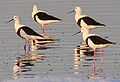
Forrestdale Lake Nature Reserve is a lake nature reserve around Forrestdale Lake in the City of Armadale, Western Australia, approximately 25 kilometres (16 mi) south of the central business district of Perth, the state capital, and on the southern fringes of the Perth metropolitan area. It lies immediately south of the suburb of Forrestdale, and 8 kilometres (5.0 mi) south-east of Jandakot Airport. It is a still largely natural wetland, with some adjoining native vegetation, surrounded by land developed for housing and agriculture, that regularly supports large numbers of shorebirds and other waterbirds.

The Quill Lakes are a wetland complex in Saskatchewan, Canada that encompasses the endorheic basin of three distinct lake wetlands: Big Quill Lake, Middle Quill Lake, and Little Quill Lake. On May 27, 1987, it was designated a wetland of international importance via the Ramsar Convention. It was the first Canadian site in the North American Waterfowl Management Plan, is a site in the International Biological Programme and Saskatchewan Heritage Marsh Program, and was designated a Western Hemisphere Shorebird Reserve Network site of International significance in May, 1994. The site is an important staging and breeding area for spring and fall migration of shorebirds. The site qualifies as an Important Bird Area (IBA) of Canada for its globally and nationally significant migratory and breeding populations of more than a dozen species of birds. The IBA is designated as Quill Lakes .

Pink Lake is a salt lake in the Goldfields-Esperance region of Western Australia. Although historically the water in the lake was visibly pink, as of 2017 it had not been pink for over ten years. Salt concentration is vital to Pink Lake's pink hue, and Pink Lake may turn pink again as conditions change. It lies about 3 kilometres (2 mi) west of Esperance and is bounded to the east by the South Coast Highway.
Lake Gore is a seasonal and semi-permanent saline lake in the Goldfields-Esperance region of Western Australia located approximately 24 km (15 mi) west of Esperance. It is an important site for waterbirds.
The Vasse-Wonnerup Estuary is an estuary in the South West region of Western Australia close to the town of Busselton. The estuary is listed with DIWA. It was also recognised as a wetland of international importance under the Ramsar Convention on 7 June 1990 when an area of 1,115 ha was designated Ramsar Site 484 as an important dry-season habitat for waterbirds. It is also the main part of the 2,038 ha (5,040-acre) Busselton Wetlands Important Bird Area.
The Port Phillip Bay and Bellarine Peninsula Ramsar Site is one of the Australian sites listed under the Ramsar Convention as a wetland of international importance. It was designated on 15 December 1982, and is listed as Ramsar Site No.266. Much of the site is also part of either the Swan Bay and Port Phillip Bay Islands Important Bird Area or the Werribee and Avalon Important Bird Area, identified as such by BirdLife International because of their importance for wetland and waterbirds as well as for orange-bellied parrots. It comprises some six disjunct, largely coastal, areas of land, totalling 229 km2, along the western shore of Port Phillip and on the Bellarine Peninsula, in the state of Victoria. Wetland types protected include shallow marine waters, estuaries, freshwater lakes, seasonal swamps, intertidal mudflats and seagrass beds.
Toolibin Lake is a seasonal fresh to brackish water perched lake or wooded swamp, in south-western Australia. The lake is contained with a 493-hectare (1,218-acre) nature reserve and it is located about 200 kilometres (124 mi) south-east of Perth, in the Shire of Narrogin, and 40 kilometres (25 mi) east of the town of Narrogin, in the Wheatbelt region of Western Australia. The lake is listed by the Australian Government as a threatened ecological community under the Environment Protection and Biodiversity Conservation Act 1999.

Thomsons Lake Nature Reserve is a lake nature reserve around Thomsons Lake in the City of Cockburn, Western Australia, approximately 25 kilometres (16 mi) south of the central business district of Perth, the state capital, and on the southern fringes of the Perth metropolitan area. It is in the suburb of Beeliar, 7 kilometres (4.3 mi) south-west of Jandakot Airport. It is a still largely natural wetland, with adjoining native vegetation, surrounded by land developed for housing and agriculture, that regularly supports large numbers of shorebirds and other waterbirds.
The Lakes Argyle and Kununurra Ramsar Site comprises an extensive system of artificial freshwater reservoirs, with their associated permanent wetlands, formed by damming the Ord River in the eastern part of the Kimberley region of northern Western Australia. The reservoirs include Lake Argyle and Lake Kununurra. There are numerous endemic plants and a rich fauna. The 1,500 km2 (580 sq mi) site was designated a wetland of international importance under the Ramsar Convention on 7 June 1990, making it Ramsar Site 478.
The Western District Lakes of Victoria, in the Western District of Victoria, south-eastern Australia, were recognised on 15 December 1982 as wetlands of international importance by listing under the Ramsar Convention, as Ramsar site no.268.
Lake McLarty is a 219-hectare (540-acre) freshwater lake and associated nature reserve on the Swan Coastal Plain of Western Australia. The lake is named after a prominent pioneering family which settled in the district in the early 1860s. It lies about 90 kilometres (56 mi) south of Perth on the eastern side of the Harvey Estuary and forms part of the Peel-Yalgorup System Ramsar site. It is an important area for waders, or shorebirds, and is a well-known birdwatching site.

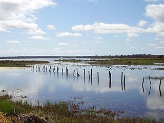
Moulting Lagoon Important Bird Area is a composite wetland site in eastern Tasmania, Australia. It comprises two adjacent and hydrologically continuous wetlands – Moulting Lagoon and the Apsley Marshes – at the head of Great Oyster Bay, near the base of the Freycinet Peninsula, between the towns of Swansea and Bicheno. Both components of the site are listed separately under the Ramsar Convention as wetlands of international significance. Moulting Lagoon is so named because it is a traditional moulting place for black swans. It is an important site for waterbirds.

The Natimuk-Douglas Wetlands comprise a chain of freshwater, brackish and saline wetlands in the semi-arid Wimmera region of western Victoria. Australia. They are important for waterbirds.
The North Victorian Wetlands, also known as the Kerang Wetlands, comprise an extensive series of over 100 freshwater, brackish and saline lakes and swamps on the floodplain of the Loddon River where it enters the Murray valley, in the vicinity of the town of Kerang, in northern Victoria, south-eastern Australia. They are important for a variety, and sometimes large numbers, of waterbirds.
The Paroo Floodplain and Currawinya Important Bird Area is a 7,874 km2 (3,040 sq mi) site comprising the floodplain and the associated wetlands of the Paroo River in north-western New South Wales and south-western Queensland, Australia. It includes extensive areas of the Paroo-Darling and Currawinya National Parks, both of which are listed under the Ramsar Convention as wetland sites of international importance, as well as of the Nocoleche Nature Reserve.

The Seagull Lake is sub-coastal saline lake fed by a marine spring located in the locality of Yanerbie on the western side of the Eyre Peninsula in South Australia within the boundaries of the Sceale Bay Conservation Park. It lies about 20 kilometres (12 mi) south of Streaky Bay and 280 kilometres (170 mi) north of Port Lincoln.

The Werribee and Avalon Important Bird Area comprises some 37 km2 of coastal land along the northwestern shore of Port Phillip in the state of Victoria, in southeastern Australia. It is important for a wide variety of waterbirds.
The Yalgorup Important Bird Area comprises a group of parallel, linear wetlands, with a collective area of 59 km2, on the Swan Coastal Plain of south-west Western Australia between the cities of Mandurah and Bunbury. It is an important site for waterbirds.
The Bellarine Wetlands Important Bird Area comprises a group of wetland sites, with a collective area of 46 km2, at the western end of the Bellarine Peninsula in Victoria, south-eastern Australia. The site is important for waterbirds and orange-bellied parrots.