Limeburners Bay

Last updated

Limeburners Bay
Limeburnersbay entrance.jpg
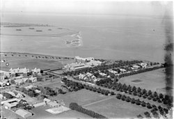
The entrance of Limeburners Bay, with Geelong Grammar School in the foreground (1939).
Australia Victoria Greater Geelong City location map.svg
Red pog.svg
Limeburners Bay
Portphillip.gif
Map of Port Phillip showing location of Corio Bay. Limeburners Bay is the small inlet at the northernmost tip of Corio Bay.
Location Victoria
Coordinates 38°04′30″S144°24′25″E / 38.075°S 144.407°E / -38.075; 144.407
Primary outflows Corio Bay; Port Phillip
Basin  countriesAustralia
Frozennever
Settlements Geelong

Limeburners Bay, one of numerous bays in Port Phillip, lies in the southwest and adjoins Corio Bay, which abuts Geelong, the second largest city in Victoria, Australia. The bay was named after lime kilns, located on the east side of Corio Bay, used to burn limestone for making cement.

In the 1820s, explorers Hume and Hovell ended their journey in the area of Limeburners Bay before returning to Sydney. It is a tide-dominated estuary that runs off Hovells Creek. The area is popular for recreational fishing and hiking and birdwatching. Geelong Grammar School overlooks the bay.

Limeburners Bay is home to many endangered species. It forms part of the Port Phillip Bay (Western Shoreline) and Bellarine Peninsula Ramsar Site as a wetland of international importance. The site is part of the Werribee and Avalon Important Bird Area, identified as such by BirdLife International because of its importance for wetland and waterbirds as well as for orange-bellied parrots. [1]

Related Research Articles

<span class="mw-page-title-main">Geelong</span> City in Victoria, Australia

Geelong is a port city in Victoria, Australia, located at the eastern end of Corio Bay and the left bank of Barwon River, about 65 km (40 mi) southwest of Melbourne.

<span class="mw-page-title-main">Port Phillip</span> Bay in Victoria, Australia

Port Phillip or Port Phillip Bay is a horsehead-shaped enclosed bay on the central coast of southern Victoria, Australia. The bay opens into the Bass Strait via a short, narrow channel known as The Rip, and is completely surrounded by localities of Victoria's two largest cities — metropolitan Greater Melbourne in the bay's main eastern portion north of the Mornington Peninsula, and the city of Greater Geelong in the much smaller western portion north of the Bellarine Peninsula. Geographically, the bay covers 1,930 km2 (750 sq mi) and the shore stretches roughly 264 km (164 mi), with the volume of water around 25 km3 (6.0 cu mi). Most of the bay is navigable, although it is extremely shallow for its size — the deepest portion is only 24 m (79 ft) and half the bay is shallower than 8 m (26 ft). Its waters and coast are home to seals, whales, dolphins, corals and many kinds of seabirds and migratory waders.

<span class="mw-page-title-main">William Hovell</span> Australian explorer

William Hilton Hovell was an English explorer of Australia. With Hamilton Hume, he made an 1824 overland expedition from Sydney to Port Phillip, and later explored the area around Western Port.

<span class="mw-page-title-main">Corio Bay</span> Bay in Victoria, Australia

Corio Bay is one of numerous internal bays in the southwest corner of Australia's Port Phillip, and is the bay on which abuts the City of Geelong. The nearby suburb of Corio takes its name from Corio Bay.

Corio is a residential and industrial area, which forms one of the largest suburbs of Geelong, Victoria in Australia. It is located approximately 9 km north of the Geelong central business district. The area was formerly known as Cowie's Creek after James Cowie, an early land owner who was active in the local and state government.

Lara is a town in Victoria, 18 km north-east of the Geelong CBD, inland from the Princes Freeway to Melbourne. Its population at the 2021 census was 19,014.

<span class="mw-page-title-main">Bellarine Peninsula</span> Peninsula in Victoria, Australia

The Bellarine Peninsula is a peninsula located south-west of Melbourne in Victoria, Australia, surrounded by Port Phillip, Corio Bay and Bass Strait. The peninsula, together with the Mornington Peninsula, separates Port Phillip Bay from Bass Strait. The peninsula itself was originally occupied by Indigenous Australian clans of the Wadawurrung nation, prior to European settlement in the early 19th century. Early European settlements were initially centred on wheat and grain agriculture, before the area became a popular tourist destination with most visitors arriving by paddle steamer on Port Phillip in the late 19th century.

<span class="mw-page-title-main">Werribee River</span> River in Victoria, Australia

The Werribee River is a perennial river of the Port Phillip catchment that is located on the expansive lowland plain southwest of Melbourne, Victoria, Australia. The headwaters of a tributary, the Lerderderg River, are north of Ballan near Daylesford and it flows across the basalt plain, through the suburb of Werribee to enter Port Phillip. A linear park follows the Werribee River along much of its course. In total the Werribee River completes a journey of approximately 110 kilometres (68 mi).

<span class="mw-page-title-main">Lake Borrie Wetlands</span>

Lake Borrie Wetlands is a coastal wetland that is located in the Greater Geelong region of Victoria, Australia. The wetland is situated within the Western Treatment Plant at Werribee; administered by Melbourne Water.

<span class="mw-page-title-main">Western Treatment Plant</span> Ramsar site and sewage treatment plant in Victoria, Australia

The Western Treatment Plant is a 110 km2 (42 sq mi) sewage treatment plant in Cocoroc, Victoria, Australia, 30 km (19 mi) west of Melbourne's central business district, on the coast of Port Phillip Bay. It was completed in 1897 by the Melbourne and Metropolitan Board of Works (MMBW), and is currently operated by Melbourne Water. The plant's land is bordered by the Werribee River to the east, the Princes Freeway to the north, and Avalon Airport to the west. It forms part of the Port Phillip Bay and Bellarine Peninsula Ramsar Site as a wetland of international importance. The Western Treatment Plant treats around fifty percent of Melbourne's sewage — about 485 megalitres or 393 acre-feet per day — and generates almost 40,000 megalitres or 32,000 acre-feet of recycled water a year.

<span class="mw-page-title-main">Lake Victoria (Victoria)</span>

Lake Victoria is a 139-hectare (340-acre) shallow saline lake on the Bellarine Peninsula, Victoria in Australia, close to the township of Point Lonsdale and part of the Lonsdale Lakes Nature Reserve administered by Parks Victoria.

<span class="mw-page-title-main">Point Wilson, Victoria</span> Place in Victoria, Australia

Point Wilson is a locality located on the northern shores of Corio Bay, Victoria. it is approximately 60 kilometres by road from Melbourne, and 25 kilometres by road from Geelong.

<span class="mw-page-title-main">Shire of Corio</span> Local government area in Victoria, Australia

The Shire of Corio was a local government area located between Geelong and Werribee, about 60 kilometres (37 mi) southwest of Melbourne, the state capital of Victoria, Australia. The shire, which included all of Geelong's northern suburbs, covered an area of 704.66 square kilometres (272.1 sq mi), and existed from 1861 until 1993.

<span class="mw-page-title-main">Geography of Port Phillip</span>

Port Phillip, sometimes referred to as Port Phillip Bay, is a large bay in southern Victoria, Australia, 1,930 km2 in area, with a coastline length of 264 km (164 mi). The bay is extremely shallow for its size, but mostly navigable. The deepest portion is only 24 m (80 ft), and half the region is shallower than 8 m. Its volume is around 25 km³. The city of Melbourne is located at its northern end, near the mouth of the Yarra River.

<span class="mw-page-title-main">Beaches in Port Phillip</span>

Port Phillip is in Victoria, Australia. It has many beaches, most of which are flat, shallow and long, with very small breaks making swimming quite safe. This attracts many tourists, mostly families, to the beaches of Port Phillip during the summer months and school holidays. Water sports such as body boarding and swimming are common, though waves are very rarely large enough for surfing. A number of lifesaving clubs operate along Port Phillip’s beaches.

The Port Phillip Bay and Bellarine Peninsula Ramsar Site is one of the Australian sites listed under the Ramsar Convention as a wetland of international importance. It was designated on 15 December 1982, and is listed as Ramsar Site No.266. Much of the site is also part of either the Swan Bay and Port Phillip Bay Islands Important Bird Area or the Werribee and Avalon Important Bird Area, identified as such by BirdLife International because of their importance for wetland and waterbirds as well as for orange-bellied parrots. It comprises some six disjunct, largely coastal, areas of land, totalling 229 km2, along the western shore of Port Phillip and on the Bellarine Peninsula, in the state of Victoria. Wetland types protected include shallow marine waters, estuaries, freshwater lakes, seasonal swamps, intertidal mudflats and seagrass beds.

Point Lillias is a narrow peninsula jutting southwards from the northern coast of Corio Bay, north of the city of Geelong, in Victoria, Australia. It was formed by a southward-trending tongue of lava from the volcanic flows of the Werribee Plains. The seaward end of the peninsula forms a low cliff fringed by shelly beach ridges. Forming the end of the same lava tongue, 500 metres to the south, is a small basalt island known as Bird Rock, connected by a submerged shoal to the peninsula. Point Lillias adjoins the evaporation ponds of the Cheetham saltworks at Avalon. It is listed as a wetland of international importance under the Ramsar Convention as part of the Port Phillip Bay and Bellarine Peninsula Ramsar Site.

The Spit Nature Conservation Reserve is a 300 ha nature reserve on the north-western shore of Port Phillip, a large bay in Victoria, Australia. It consists of public land set aside to conserve and protect species, communities, and habitats of indigenous plants and animals. It is adjacent to the Werribee Sewage Farm and is managed by Parks Victoria.

<span class="mw-page-title-main">Werribee and Avalon Important Bird Area</span>

The Werribee and Avalon Important Bird Area comprises some 37 km2 of coastal land along the northwestern shore of Port Phillip in the state of Victoria, in southeastern Australia. It is important for a wide variety of waterbirds.

<span class="mw-page-title-main">Bellarine Wetlands Important Bird Area</span>

The Bellarine Wetlands Important Bird Area comprises a group of wetland sites, with a collective area of 46 km2, at the western end of the Bellarine Peninsula in Victoria, south-eastern Australia. The site is important for waterbirds and orange-bellied parrots.

References

  1. BirdLife International. (2011). Important Bird Areas factsheet: Werribee and Avalon. Downloaded from http://www.birdlife.org on 2011-11-23.