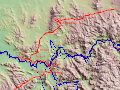
Hume and Hovells 1824 expedition is shown by the broken line
The Hume and Hovell expedition was a journey of exploration undertaken in eastern Australia. In 1824 the Governor of New South Wales, Sir Thomas Brisbane, commissioned Hamilton Hume and former Royal Navy Captain William Hovell to lead an expedition to find new grazing land in the south of the colony, and also to find an answer to the mystery of where New South Wales's western rivers flowed.
Surveyor General John Oxley asserted that no river could fall into the sea between Cape Otway and Spencer's Gulf, and that the country south of parallel of 34 degrees was ' uninhabitable and useless for all purposes of civilised men,' and for the time exploration in this direction was greatly discouraged. In 1824, newly appointed Sir Thomas Brisbane, who disbelieved this statement, offered to land a party of prisoners near Wilson's Promontory and grant them a free pardon, as well as a grant of land, to those who found their way overland to Sydney.[1]
Alexander Berry recommended the Governor to secure the services of Hume to lead the exploring party. Hume declined to undertake that task but instead offered, if supplied with men and horses, to go from Lake George to Bass Straits. This was not carried out. But shortly afterwards Hume and W. H. Hovell, of Minto, agreed together to undertake an expedition in that direction. They found men and horses and bullocks; the Government furnished them with pack saddles, tarpaulins, tent, arms, ammunition, and skeleton charts.[2]
On 2 October 1824, Hovell and Hume met at Hume's house in Appin, and started upon their expedition. The party, when complete, consisted of eight people, Hume and his three men, Claude Bossowa, Henry Angel, and James Fitzpatrick. As well as Hovell and his three men, Thomas Boyd, William Bollard, and Thomas Smith.
They reached Hume's station near 'Lake George' on the 13th. In those times, 'Lake George' also referred to the district, and Hume's station, Wooloobidallah—later called Collingwood Station—was closer to modern-day Gunning than to the lake. However, some of the party did make an excursion to the lake. On the 14th, "Hume and Hovell, with two of the men, proceed to Lake George, in order to ascertain the bearings and distance of the Lake from Hume's station". They returned to Hume's station at dusk. They started their journey on the 17th. On the 18th, they camped near the site of Hume's later residence, Cooma Cottage. On the 19th they passed Yarrh – or as they are now called Yass Plains.
Their first great difficulty was in crossing the Murrumbidgee which was in full flood at the time. The timber growing on the banks of this river was too heavy to float, so Hume resolved to make a raft of the body of one of their carts. Hume and Hovell's man Boyd, swam across the river first, with a small rope between their teeth, to which was attached a line long enough to reach across the river. It was a work of peril, as the current was strong. But they succeeded, and then, with much labour, got the whole party, with baggage and cattle, safely over.
On 24 October they came up to what seemed an impenetrable mountain barrier. There was an argument between the leaders concerning the best route to take which resulted in the party splitting up. The equipment was divided, and they prepared to cut their one tent in halves. Hume and Hovell fought bitterly over the frying-pan, which broke in their hands. One of them taking the handle, the other the pan itself. Later, however, Hovell rejoined Hume when he found he had made a mistake.[3]
Hume, with two men, following a chain of ponds, came to a chasm through which the whole party afterwards descended. On the 31st they found themselves on the western edge of the tableland. The descent was not accomplished without much difficulty. On 6 November, they came in sight of the snow-covered Australian Alps. They came after this upon a very rich country, abounding in kangaroos and other animals, with frequent tracks of aborigines; and on Tuesday, 16 November, they arrived suddenly on the banks of a "fine river".
Hume was the first to see the river, near the site of Albury and named it the "Hume", (now the Murray River) after his father. This river, where they first came upon it, is about 50m in breadth, and of considerable depth. The current was about three miles an hour, and the water clear.
They improvised a tarpaulin covered wicker boat and they were able to eventually cross and continue into what is now known as Victoria.
Four days after crossing the Goulburn River, impassable country was reached. The party spent three days attempting to cross the Great Dividing Range at Mt Disappointment but were thwarted. Hume shifted direction to the west and, on the 12 December, reached less hilly country at the future township of Broadford, where they camped.[4]
Hume headed towards similarly low ranges to the south and found a pass in that direction next day. He led the party across the Dividing Range at Hume’s Pass, Wandong, and, on 16 December 1824, reached Corio Bay, an arm of Port Phillip Bay, at Bird Rock, Point Lillias, north of the future site of Geelong.[5]
Hovell left incontrovertible surveying proof of the Geelong location when he took a bearing of N10W (350 degrees) from there to Mt Flinders (Mt Wollstonecraft, You Yangs), at a distance of 8 miles, and wrote it in his diary that still exists. [6]
Hovell claimed that he had measured their longitude on the same day but, in reality, he had read it off the sketch map that they had drafted themselves during the trip.[7] In 1867, Hovell admitted that he did not take any longitude measurements and blamed Hume for it. [8]
Prior to that admission, Dr William Bland, who wrote the first book on the journey in 1831, invented the myth that Hovell made an error of one degree in longitude in order to protect the explorer.[9] It was not the only myth emanating from the pen of Bland. From 1825, Hume wrote on four occasions that he had reached Western Port, his original destination. That was repeated in nine newspaper articles by Bland. It was not until 1827, when it was demonstrated by Hovell that the journey had ended near Geelong, that the pair changed their stories to identify that location.[10]
On 18 December, the party turned back towards New South Wales. Hume chose to travel more to the west to avoid the mountainous country and save considerable time. It was a sound decision because, on 16 January 1825, just as their flour ran out, they reached the carts they had left behind. Two days later, they arrived at Hume's station at Gunning.[11]
On 18 November 1826, based on the discoveries of Hume and Hovell, Colonel Stewart, Captain S. Wright, and Lieutenant Burchell were sent in HMSFly (Captain Wetherall), with the brigs Dragon and Amity, under orders to proceed to Western Port and establish a colony there. They took a number of convicts and a small force of troops from the 3rd and 93rd regiments. Hovell was sent with the party as guide. While exploring Western Port, it became apparent to Hovell that he had not reached it on his earlier trip.[12]
Both Hovell and Hume were publicly rebuked for their error in incorrectly identifying Western Port. They had become implicated by association with the wasted expense of setting up a new settlement there, based upon their fulsome recommendations of the value of the region.[13][14]
Relations between the "currency lad" (first-generation Australian) Hume and the aloof Englishman Hovell had deteriorated, and they raced each other back to Sydney to claim credit for their discoveries. They arrived in January, 1825, and were both rewarded with large land grants by Governor Brisbane. They later published conflicting accounts of the journey, each claiming leadership.
The Hume and Hovell expedition disproved the widely held view that the interior of Australia was an uninhabitable wilderness. They found abundant well-watered grazing land between the Murrumbidgee and the Murray, on the huge fertile coastal plains around Port Phillip, and then on the plains across North Eastern Victoria all the way to the Murray River during their return journey. It took another thirteen years for settlers from New South Wales to follow their route in 1837, and only after the richness of the territory was confirmed by Sir Thomas Mitchell in 1836. Some parts of their route formed the Hume Highway from Sydney to Melbourne via Albury.
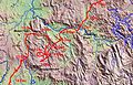
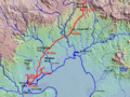
The route
Route of Hume & Hovell expedition, 5 to 12 November 1824
Route of Hume & Hovell expedition 12 to 21 November 1824
Route of Hume & Hovell expedition 22 to 30 November 1824
Route of Hume & Hovell expedition 1 to 14 December 1824
Route of Hume & Hovell expedition 15 to 19 December 1824
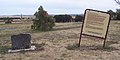
Monuments
Within the Greater Melbourne area, monuments commemorating the route of the Hume and Hovell expedition can be found at Beveridge, Greenvale, St. Albans, Werribee and Lara.[15] There are also monuments in other locations in north-eastern Victoria and southern New South Wales.
This Beveridge Monument and interpretive panel was built in 1999, at the foot of Mount Fraser, to mark the location from which Hume & Hovell first sighted the sea. The original monument, erected in 1924, is on private land nearby.
↑ Hovell, William H., Remarks on a journey from Lake George, Lat. 35 deg. 5 min., Long. – towards Western Port, 2 October – 21 December 1824, Safe 1/32b, IE3447307, 1825, p. 143, SLNSW.
↑ Williams, Martin. Hamilton Hume Sketch Maps: Origins and Modern Treatment, Victorian Historical Journal, Vol. 92, No. 1, June 2021, p. 21.
↑ Hovell, William H., Remarks on a journey from Lake George, Lat. 35 deg. 5 min., Long. – towards Western Port, 2 October – 21 December 1824, Safe 1/32b, IE3447307, 1825, p. 164, SLNSW.
↑ Williams, Martin. Hamilton Hume Sketch Maps: Origins and Modern Treatment, Victorian Historical Journal, Vol. 92, No. 1, June 2021, p. 13.
↑ William H. Hovell, Answer to the Preface to the Second Edition of Mr. Hamilton Hume’s ‘A Brief Statement of Facts’ in Connection with an Overland Expedition from Lake George to Port Phillip, in 1824, Sydney, J. Ferguson, 1874, p. 8.
↑ William Bland, Journey of Discovery to Port Phillip, New South Wales; by Messrs. W. H. Hovell, and Hamilton Hume in 1824 and 1825. W. Bland, Sydney, A.H. Hill, 1831, Facsimile Edition, Adelaide Libraries Board of South Australia, 1965, p. iii.
↑ Williams, Martin. Hamilton Hume Sketch Maps: Origins and Modern Treatment, Victorian Historical Journal, Vol. 92, No. 1, June 2021, p. 10.
The history of Victoria refers to the history of the Australian state of Victoria and the area's preceding Indigenous and British colonial societies.
Hamilton Hume was an early explorer of the present-day Australian states of New South Wales and Victoria. In 1824, along with William Hovell, Hume participated in an expedition that first took an overland route from Sydney to Port Phillip. Along with Sturt in 1828, he was part of an expedition of the first Europeans to find the Darling River.
The Hume Highway, including the sections now known as the Hume Freeway and the Hume Motorway, is one of Australia's major inter-city national highways, running for 840 kilometres (520 mi) between Melbourne in the southwest and Sydney in the northeast. Upgrading of the route from Sydney's outskirts to Melbourne's outskirts to dual carriageway was completed on 7 August 2013.
John Joseph William Molesworth Oxley was an English explorer and surveyor of Australia in the early period of British colonisation. He served as Surveyor General of New South Wales and is perhaps best known for his two expeditions into the interior of New South Wales and his exploration of the Tweed River and the Brisbane River in what is now the state of Queensland.
William Hilton Hovell was an English explorer of Australia. With Hamilton Hume, he made an 1824 overland expedition from Sydney to Port Phillip, and later explored the area around Western Port.
Charles Napier Sturt was a British officer and explorer of Australia, and part of the European exploration of Australia. He led several expeditions into the interior of the continent, starting from Sydney and later from Adelaide. His expeditions traced several of the westward-flowing rivers, establishing that they all merged into the Murray River, which flows into the Southern Ocean. He was searching to prove his own passionately held belief that an "inland sea" was located at the centre of the continent. He reached the rank of Captain, served in several appointed posts, and on the Legislative Council.
George William Evans was a surveyor and early explorer in the Colony of New South Wales. Evans was born in Warwick, England, migrating to Australia in October 1802.
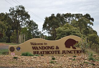
Wandong is a town in Victoria, Australia. The town is about 50 kilometres (30 mi) north of the state capital, Melbourne, on the Hume Highway. It adjoins the town of Heathcote Junction, and at the 2016 census, the two towns had a population of 1,340. The main centre nearest Wandong is Kilmore.
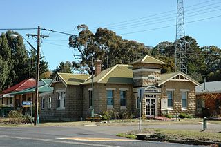
Broadford is a town in central Victoria, Australia. At the 2021 census, Broadford had a population of 4,076. The town is the headquarters of the Shire of Mitchell local government area and is approximately 73 kilometres (50 mi) north of the state capital, Melbourne.
Mount Macedon is a dormant volcano that is part of the Macedon Ranges of the Great Dividing Range, located in the Central Highlands region of Victoria, Australia. The mountain has an elevation of 1,001 metres (3,284 ft) with a prominence of 643 metres (2,110 ft) and is located approximately 65 kilometres (40 mi) northwest of Melbourne.
The Hume and Hovell Walking Track stretches over 440 kilometres (270 mi) between Yass and Albury, in New South Wales, Australia. The track allows walkers to rediscover the route of explorers Hamilton Hume and William Hovell on their expedition to Port Phillip in 1824.
Appin is a town on the south-west fringe of Sydney in the Macarthur Region in Tharawal country near its boundary with Gandangara country, New South Wales, Australia in Wollondilly Shire. It is situated about 16 kilometres (9.9 mi) south of Campbelltown and 35 kilometres (22 mi) northwest of Wollongong.
Mount Disappointment is an 800-metre (2,600 ft) mountain located on the southern end of the Great Dividing Range, 9.5 kilometres (5.9 mi) north of Whittlesea and 60 kilometres (37 mi) north of Melbourne, the state capital of Victoria, Australia. It was named by explorers Hume and Hovell in 1824, and is now a popular hiking spot.
Point Lillias is a narrow peninsula jutting southwards from the northern coast of Corio Bay, north of the city of Geelong, in Victoria, Australia. It was formed by a southward-trending tongue of lava from the volcanic flows of the Werribee Plains. The seaward end of the peninsula forms a low cliff fringed by shelly beach ridges. Forming the end of the same lava tongue, 500 metres to the south, is a small basalt island known as Bird Rock, connected by a submerged shoal to the peninsula. Point Lillias adjoins the evaporation ponds of the Cheetham saltworks at Avalon. It is listed as a wetland of international importance under the Ramsar Convention as part of the Port Phillip Bay and Bellarine Peninsula Ramsar Site.
Corinella is a town in Victoria, Australia, located 114 km south-east of Melbourne via the M1 and the Bass Highway, on the eastern shore of Western Port.
Coronet Bay is a town in Victoria, Australia, located 114 km south-east of Melbourne via the M1 and the Bass Highway, on the eastern shore of Western Port Bay.
European land exploration of Australia deals with the opening up of the interior of Australia to European settlement which occurred gradually throughout the colonial period, 1788–1900. A number of these explorers are very well known, such as Burke and Wills who are well known for their failed attempt to cross the interior of Australia, as well as Hamilton Hume and Charles Sturt.
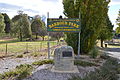
Gunning Shire was a local government area in New South Wales centered on Gunning, New South Wales north of the Australian Capital Territory until February 2004, when the local government organisation was absorbed into newly created Palerang Council and Upper Lachlan Shire.
The European exploration of Australia first began in February 1606, when Dutch navigator Willem Janszoon landed in Cape York Peninsula and on October that year when Spanish explorer Luís Vaz de Torres sailed through, and navigated, Torres Strait islands. Twenty-nine other Dutch navigators explored the western and southern coasts in the 17th century, and dubbed the continent New Holland. Most of the explorers of this period concluded that the apparent lack of water and fertile soil made the region unsuitable for colonisation.
Hume’s Pass is a low pass on the Great Dividing Range in central Victoria, Australia. It is located at Wandong in the Shire of Mitchell local government area, 53 kilometres (33 mi) from the state capital, Melbourne.
References
Hume and Hovell, 1824. Edited by Alan E. I. Andrews: Blubber Head Press, Hobart, 1981.
This page is based on this Wikipedia article Text is available under the CC BY-SA 4.0 license; additional terms may apply. Images, videos and audio are available under their respective licenses.