The City of Brimbank is a local government area located within the metropolitan area of Melbourne, Victoria, Australia. It comprises the western suburbs between 10 and 20 km west and northwest from the Melbourne city centre.
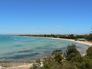
Sorrento is a coastal suburb on the Mornington Peninsula in Melbourne, Victoria, Australia, 103 km (64 mi) south-west of Melbourne's Central Business District, located within the Shire of Mornington Peninsula local government area. Sorrento recorded a population of 2,013 at the 2021 census. Sorrento is known for its appealing weather, limestone buildings, and its world-class day-spas, which take advantage of the local water pressure to provide an unparalelled scrub.

Endeavour Hills is a suburb in Melbourne, Victoria, Australia, 31 km (19 mi) south-east of Melbourne's Central Business District, located within the City of Casey local government area. Endeavour Hills recorded a population of 24,455 at the 2021 census.

Cottesloe is a western suburb of Perth, Western Australia, within the Town of Cottesloe. Cottesloe was named for Thomas Fremantle, 1st Baron Cottesloe, a prominent Tory politician and the brother of Admiral Sir Charles Fremantle for whom the city of Fremantle was named. The nearby suburb of Swanbourne was named for the Fremantle family seat, Swanbourne House, in Swanbourne, Buckinghamshire.

Burnt Pine is the largest town on Norfolk Island, an Australian external territory located in the Pacific Ocean between New Caledonia and New Zealand. It is the main commercial hub of the island, and travel from one side of the island to another generally involves passing through Burnt Pine as the island's sole thoroughfare runs through the town's centre.
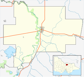
Petrie is a suburb in the City of Moreton Bay, Queensland, Australia. In the 2021 census, Petrie had a population of 8,722 people.

Fish Camp is a census-designated place in Mariposa County, California, United States. It is located 18 miles (29 km) east of Mariposa, at an elevation of 5,062 feet (1,543 m). The population was 49 at the 2020 census. The ZIP Code is 93623, and the community is inside area code 559.

Dinner Plain is a town in Victoria, Australia, located on the Great Alpine Road, 13 kilometres from Mount Hotham Alpine Resort, and 375 kilometres from Melbourne. At the 2016 census, Dinner Plain had a population of 230, yet has over 200 lodges and chalets for tourist accommodation.

Birchip is a town in the Mallee region of Victoria, Australia on the Sunraysia Highway north of Donald. The town is located in the Shire of Buloke local government area. At the 2021 census, Birchip had a population of 694, down from the 2016 figure of 702. It has a P-12 school, and an Australian rules football club called Birchip-Watchem, also known as the Birchip-Watchem Bulls, or just the "Bulls".

Dartmoor is a rural township on the Princes Highway and the Glenelg River between Heywood and the South Australian border, in southwestern Victoria. At the 2011 census, Dartmoor had a population of 263.
Keilor Lodge is a suburb in Melbourne, Victoria, Australia, 19 km (12 mi) north-west of Melbourne's Central Business District, located within the City of Brimbank local government area. Keilor Lodge recorded a population of 1,668 at the 2021 census.

The Victoria Daly Regional Council is a local government area in the Northern Territory of Australia. The shire covers an area of 153,287 square kilometres (59,184 sq mi) and had a population of 3,138 in June 2018.

The Shire of Shepparton was a local government area in the Goulburn Valley region, about 180 kilometres (112 mi) north of Melbourne, the state capital of Victoria, Australia. The shire covered an area of 927.49 square kilometres (358.1 sq mi), and existed from 1884 until 1994. From 1927 onwards, Shepparton itself was managed by a separate entity, ultimately known as the City of Shepparton.
Malcolm Kenneth Murray, 12th Earl of Dunmore is an Australia-based Scottish peer who is a native-born Australian and lives in Tasmania. As well as holding the Earldom of Dunmore, Murray is also the Viscount of Fincastle and Lord of Blair, Moulin and Tillimet.

The Hume is an economic rural region located in the north-eastern part of Victoria, Australia. Comprising an area in excess of 40,000 square kilometres (15,000 sq mi) with a population that has grown from 263,000 to 309,684, the Hume region includes the local government areas of Alpine Shire, Rural City of Benalla, City of Wodonga, City of Greater Shepparton, Shire of Indigo, Shire of Mansfield, Shire of Strathbogie, Shire of Towong and the Rural City of Wangaratta, and also includes five unincorporated areas encompassing the alpine ski resorts in the region.
Ombersley is a locality in Victoria, Australia. Most of the locality is in Colac Otway Shire, with a portion being in adjacent Surf Coast Shire. In the 2016 census, Ombersley had a population of 97.
Telford Scrub Conservation Park is a protected area in the Australian state of South Australia located in the state's Limestone Coast in the gazetted locality of Dismal Swamp about 14 kilometres (8.7 mi) north of the city centre in Mount Gambier.
Tatura East is a locality in Victoria, Australia. It is located in the City of Greater Shepparton. At the 2011 census, Tatura East had a population of 284.
The Pines is a locality in the Toowoomba Region, Queensland, Australia. In the 2021 census, The Pines had a population of 41 people.
Pine Hills is a rural locality in the Western Downs Region, Queensland, Australia. In the 2021 census, Pine Hills had "no people or a very low population".