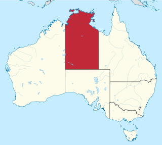
The Northern Territory is a federal Australian territory in the central and central northern regions of Australia. It is the third largest Australian federal division with an area of 1,349,129 square kilometres (520,902 sq mi) but the least populous with 228,833 inhabitants as at the 2016 Census. The Northern Territory is divided administratively into 17 Local government areas (LGAs) generally known as Councils who are responsible for providing local government services.

Gippsland is an economic rural region of Victoria, Australia, located in the south-eastern part of that state. It covers an area of 41,556 square kilometres (16,045 sq mi), and lies to the east of the eastern suburbs of Greater Melbourne, to the north of Bass Strait, to the west of the Tasman Sea, to the south of the Black-Allan Line that marks part of the Victorian/New South Wales border, and to the east and southeast of the Great Dividing Range that lies within the Hume region and the Victorian Alps. Gippsland is generally broken down into the East Gippsland, South Gippsland, West Gippsland, and the Latrobe Valley statistical divisions.

The City of Greater Bendigo is a local government area in Victoria, Australia, located in the central part of the state. It covers an area of 3,048 square kilometres (1,177 sq mi) and, at the 2016 Census, had a population of 110,477. It includes the city of Bendigo and the towns of Axedale, Elmore, Heathcote, Marong, Raywood and Strathfieldsaye. It was formed in 1994 from the amalgamation of the former City of Bendigo with the Borough of Eaglehawk, Shire of Strathfieldsaye, Shire of Huntly, Rural City of Marong and parts of the Shire of McIvor.

The Rural City of Swan Hill is a local government area in Victoria, Australia, located in the north-western part of the state. It covers an area of 6,117 square kilometres (2,362 sq mi) and, at the 2016 Census, had a population of 20,584. It includes the towns of Swan Hill, Lake Boga, Manangatang, Nyah, Nyah West, Piangil, Robinvale, Ultima and Woorinen South. It was formed in 1995 from the amalgamation of the City of Swan Hill, Shire of Swan Hill and part of the Shire of Kerang.

The City of Warrnambool is a local government area in the Barwon South West region of Victoria, Australia, located in the south-western part of the state. It covers an area of 120.7 square kilometres (46.6 sq mi) and at the 2016 Census had a population of over 33,000. It is entirely surrounded by the Shire of Moyne and the Southern Ocean. It is one of only a few regional councils in Victoria to remain serving just one urban district after the amalgamation process of 1994, although through that process it did gained some portions of the former Shire of Warrnambool.
The Rural City of Benalla is a local government area in the Hume region of Victoria, Australia, located in the north-east part of the state. It covers an area of 3,843 square kilometres (1,484 sq mi) and, at the 2016 Census had a population of almost 14,000.

Port Campbell is a coastal town in Victoria, Australia. The town is on the Great Ocean Road, west of the Twelve Apostles, in the Shire of Corangamite. At the 2016 census, Port Campbell had a population of 478.

The eastern states of Australia are the states adjoining the east coast of Australia. These are the mainland states of Victoria, Queensland, and New South Wales; the Australian Capital Territory and Jervis Bay Territory, while not states, are also included. The term usually includes the island state of Tasmania. On some occasions, the state of South Australia is included in this grouping.

Donald is a town in Victoria, Australia, located on the Richardson River, at the junction of Sunraysia Highway and Borung Highway, in the Shire of Buloke. At the 2016 census, it had a population of 1,498.

The states and territories are the first-level administrative divisions of the Commonwealth of Australia. They are the second level of government in Australia, located between the federal and local government tiers.
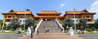
In Australia, Buddhism is a minority religion. According to the 2016 census, 2.4 percent of the total population of Australia identified as Buddhist. It was also the fastest-growing religion by percentage, having increased its number of adherents by 79 percent between the 1996 and 2001 censuses. The highest percentage of Buddhists in Australia is present in Christmas Island,where Buddhism constitute 18.1% of the total population according to the 2016 Census.Buddhism is the third largest religion in the country after Christianity and Islam.

Newton is a civil parish and small village in Cambridgeshire, England. Situated around 7 miles to the south-west of Cambridge, it lies on the old coaching road between London and Cambridge. Its population in 2001 was 401, falling to 378 at the 2011 Census.

Harston is a village and civil parish in South Cambridgeshire, England, located around 5 miles (8 km) south of Cambridge. In 2011, it had a population of 1,740.
Indian Australians are Australians of Indian descent or heritage. This includes both those who are Australian by birth, and those born in India or elsewhere in the Indian diaspora. They are one of the fastest growing communities in Australia today.

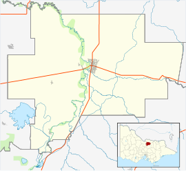
The Shire of Rodney was a local government area in the Goulburn Valley region, about 170 kilometres (106 mi) north of Melbourne, the state capital of Victoria, Australia, located between Kyabram and Shepparton. The shire covered an area of 1,009.92 square kilometres (389.9 sq mi), and existed from 1886 until 1994.

Waitchie is a locality in Victoria, Australia, located approximately 44 km from Swan Hill, Victoria. At the 2006 census, Waitchie had a population of 118, decreasing to 48 at the 2016 census.

Wargan is a locality in Victoria, Australia, located approximately 26 km from Mildura, Victoria. At the 2006 census, Wargan had a population of 71.
The history of Jainism in Australia is relatively short when compared with the histories of Christianity on the same continent. There are four Jain centres in Australia. The Jain population in Australia was counted in the 2016 census to be 4,047, of whom 38% lived in Greater Sydney, 31% in Greater Melbourne, and 15% in Greater Perth. The states and territories with the highest proportion of Jains are Western Australia (0.025%) and Victoria (0.022%), whereas those with the lowest are Queensland (0.006%) and Tasmania (0.001%).

The Grampians is an economic rural region located in the western part of Victoria, Australia. The 48,646-square-kilometre (18,782 sq mi) region lies to the northwest of the western suburbs of Greater Melbourne, to the state's western border with South Australia and includes the Grampians National Park and significant gold mining heritage assets. The Grampians region has two sub-regions, Grampians Central Highlands and Wimmera Southern Mallee.

Victoria Hill is a locality spit between the Southern Downs Region and the Toowoomba Region, both in Queensland, Australia. In the 2016 census, Victoria Hill had a population of 30 people.