Beaconsfield is a suburb of Melbourne, Victoria, Australia, 40 km south-east of Melbourne's Central Business District, located within the Shire of Cardinia local government area. Beaconsfield recorded a population of 6,714 at the 2016 Census.

Hopetoun is a town which serves as the major service centre for the Southern Mallee area of Victoria, Australia. Hopetoun is situated 400 kilometres north-west of Melbourne on the Henty Highway in the Shire of Yarriambiack. In the 2016 census, Hopetoun had a population of 739.

Warracknabeal is a wheatbelt town in the Australian state of Victoria. Situated on the banks of the Yarriambiack Creek, 330 km north-west of Melbourne, it is the business and services centre of the northern Wimmera and southern Mallee districts, and hosts local government offices of the Shire of Yarriambiack. At the 2011 census Warracknabeal district had a population of 2,745, of which 2,340 lived in the urban town centre.

Anglesea is a town in Victoria, Australia. It is located on the Great Ocean Road in the Surf Coast Shire local government area. In the 2016 census, Anglesea had a population of 2,545 people.

Avenel is a small town in Victoria, Australia. It is in the Shire of Strathbogie local government area. At the 2016 census, Avenel had a population of 1,048, up from 728 at the 2006 census and 552 at the 2001 census.

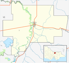
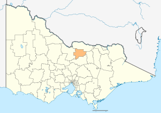
Kyabram is located in the centre of a rich irrigation district in the Goulburn River Valley, in the Australian state of Victoria, 200 kilometres (120 mi) north of Melbourne. Kyabram, the second-largest town in the Shire of Campaspe, is situated between the towns of Echuca and Shepparton and is close to the Murray River, Goulburn River, Campaspe River and Waranga Basin. As of the 2011 census the town had a population of 7,321 people and provides services to a district population of around 16,000.

Birchip is a town in the Mallee region of Victoria, Australia on the Sunraysia Highway north of Donald. The town is located in the Shire of Buloke local government area. At the 2016 census, Birchip had a population of 702, up from the 2011 figure of 662. It has a P-12 school, and an Australian rules football club called Birchip-Watchem, also known as the Birchip-Watchem Bulls, or just the "Bulls".

Boort is a town in Victoria, Australia, located next to Lake Boort, in the Shire of Loddon. The town is known for its native birdlife. Boort is a local Aboriginal word meaning "Smoke from the hill".

Donald is a town in Victoria, Australia, located on the Richardson River, at the junction of Sunraysia Highway and Borung Highway, in the Shire of Buloke. At the 2016 census, it had a population of 1,498.

Pyramid Hill is a town in Victoria, Australia in the Shire of Loddon 234 kilometres (145 mi) north of Melbourne and 86 kilometres (53 mi) north of Bendigo. At the 2011 census, Pyramid Hill had a population of 419. The town has a railway station.

Irymple is a town in the state of Victoria in Australia. Located in the region of Sunraysia in the far North-West Victoria, Irymple is 6 km south of Mildura and 550 km northwest of Melbourne. At the 2016 census, Irymple and the surrounding area had a population of 5,325.

Broadford is a small town in central Victoria, Australia. At the 2016 census, Broadford had a population of 4,319. The town is the headquarters of the Shire of Mitchell local government area and is approximately 73 kilometres (50 mi) north of the state capital, Melbourne.

Barooga is a border town in the Riverina region of New South Wales, Australia, located in the Berrigan Shire local government area. It is situated just north of the Murray River which forms the border with Victoria. Barooga's population at the 2011 census was 1,498.

Beulah is a town in the southern Mallee region of Victoria, Australia. The town is in the Shire of Yarriambiack local government area, 395 kilometres north-west of the state capital, Melbourne. At the 2016 census, Beulah had a population of 329.

Lockington is a town in northern Victoria, Australia in the Shire of Campaspe local government area, 198 kilometres north of the state capital, Melbourne. At the 2016 census, Lockington had a population of 808.

Pimpinio is a small township in Victoria, Australia 15 km from the City of Horsham. At the 2006 census, Pimpinio had a population of 338.

Balmoral is a township in the Shire of Southern Grampians in the Western District of Victoria, Australia. At the 2016 census, Balmoral and the surrounding area had a population of 294.

Culgoa is a town in the Mallee region in the north west of the Australian state of Victoria. The town is approximately 319 kilometres (198 mi) from the state capital, Melbourne. At the 2016 census, Culgoa had a population of 101, declining from 339 in 2011.

Rokewood is a small rural township in Victoria, Australia in the Golden Plains Shire, 133 kilometres (83 mi) west of the state capital, Melbourne. At the 2016 census, Rokewood and the surrounding area had a population of 217.

Mitiamo is a town in northern Victoria, Australia. It is in the Shire of Loddon, 222 kilometres (138 mi) north of the state capital, Melbourne. At the 2016 census, Mitiamo had a population of 117.