Perth is the capital city of Western Australia. It is the fourth most populous city in Australia, with a population of over 2.3 million within Greater Perth as of 2023. It is part of the South West Land Division of Western Australia, with most of Perth's metropolitan area on the Swan Coastal Plain between the Indian Ocean and the Darling Scarp. The city has expanded outward from the original British settlements on the Swan River, upon which its central business district and port of Fremantle are situated.

Western Australia (WA) is the westernmost state of Australia. It is bounded by the Indian Ocean to the north and west, the Southern Ocean to the south, the Northern Territory to the north-east, and South Australia to the south-east. Western Australia is Australia's largest state, with a land area of 2,527,013 square kilometres (975,685 sq mi), and is also the second-largest subdivision of any country on Earth, surpassed only by the Sakha Republic in eastern Russia, and formerly Northwest Territories in Canada, before the creation of Nunavut. It is also the largest proper subnational entity, being a state rather than a territory or an autonomous region.

The population of Australia is estimated to be 27,601,700 as of 6 January 2025. It is the 54th most populous country in the world and the most populous Oceanian country. Its population is concentrated mainly in urban areas, particularly on the Eastern, South Eastern and Southern seaboards, and is expected to exceed 30 million by 2029.

Shepparton is a city located on the floodplain of the Goulburn River in northern Victoria, Australia, approximately 181 kilometres (112 mi) north-northeast of Melbourne. As of the 2021 census, the estimated population of Shepparton, including the adjacent town of Mooroopna, was 53,841.
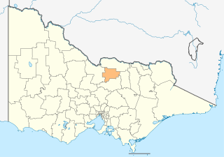
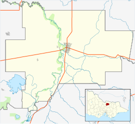
The City of Greater Shepparton is a local government area in the Hume region of Victoria, Australia, located in the north-east part of the state. It covers an area of 2,422 square kilometres (935 sq mi) and, in August 2021, had a population of 68,409. It includes the city of Shepparton and the towns of Arcadia, Ardmona, Congupna, Dookie, Grahamvale, Kialla, Lemnos, Merrigum, Mooroopna, Murchison, Tallygaroopna, Tatura, Toolamba and Undera. It was formed in 1994 from the amalgamation of the City of Shepparton, Shire of Shepparton, and parts of the Shire of Rodney, Shire of Euroa, Shire of Goulburn, Shire of Tungamah, Shire of Violet Town and Shire of Waranga.
The City of Canada Bay is a local government area in the Inner West region of Sydney, New South Wales, Australia. The city was formed on 1 December 2000, following the merger of Concord and Drummoyne councils. The city covers an area of 19.82 square kilometres (7.65 sq mi) and as at the 2021 census had a resident population of 89,177. The city is ultimately named after Canada Bay, a bay and suburb along the Parramatta River.

The City of Mount Isa is a local government area in north west Queensland. The City covers the urban locality of Mount Isa, the administrative centre, and surrounding area, sharing a boundary with the Northern Territory to the west.

Larapinta is an outer southern industrial suburb in the City of Brisbane, Queensland, Australia.

The Shire of Coolgardie is a local government area in the Goldfields–Esperance region of Western Australia, lying roughly west and south of the city of Kalgoorlie. The Shire covers an area of 30,400 square kilometres (11,738 sq mi), and its seat of government is the town of Coolgardie, although the twin towns of Kambalda East and Kambalda West contain two-thirds of the Shire's population.

The City of Albury is a local government area in the Riverina region of New South Wales, Australia. The area covers 305.9 square kilometres (118.1 sq mi) to the north of the Murray River. The area extends around 10 to 12 kilometres east and west along the river from the centre of Albury and up to 20 kilometres (12 mi) north. The population of the City of Albury area was 53,767 in June 2018.

The City of Kalamunda is a local government area in the eastern metropolitan region of the Western Australian capital city of Perth about 25 kilometres (16 mi) east of Perth's central business district. The area covers 324 square kilometres (125 sq mi), much of which is state forest rising into the Darling Scarp to the east. As of 2021, the city had a population of 58,762.

The County of Moira is one of the 37 counties of Victoria which are part of the cadastral divisions of Australia, used for land titles. It is located to the east of the Goulburn River, south of the Murray River, and west of part of the Ovens River. Part of Wangaratta is in the county, on the eastern end of it. It also includes Shepparton. The Shire of Moira is in a similar area.

The Shire of Shepparton was a local government area in the Goulburn Valley region, about 180 kilometres (112 mi) north of Melbourne, the state capital of Victoria, Australia. The shire covered an area of 927.49 square kilometres (358.1 sq mi), and existed from 1884 until 1994. From 1927 onwards, Shepparton itself was managed by a separate entity, ultimately known as the City of Shepparton.

The City of Shepparton was a local government area in the Goulburn Valley region, about 180 kilometres (112 mi) north of Melbourne, the state capital of Victoria, Australia. The city covered an area of 26.71 square kilometres (10.3 sq mi), and existed from 1927 until 1994. It excluded areas such as Mooroopna and Kialla, which are now considered to be suburbs.

Kialla is a suburb within the City of Greater Shepparton local government area in the Goulburn Valley, Victoria, Australia. At the 2016 census, Kialla and surrounding area had a population of approximately 6,800.

Seven Creeks is a creek in Victoria, Australia that is a part of the Murray-Darling Basin. The confluence of this river is located in Kialla, flowing into the Goulburn River. The creek passes through Euroa.

The Grampians is an economic rural region located in the western part of Victoria, Australia. The 48,646-square-kilometre (18,782 sq mi) region lies to the northwest of the western suburbs of Greater Melbourne, to the state's western border with South Australia and includes the Grampians National Park and significant gold mining heritage assets. The Grampians region has two sub-regions: the Central Highlands and Wimmera Southern Mallee.

The Euroa Gazette is a newspaper published weekly in Euroa, Victoria, Australia.
Miepoll is a locality in the Goulburn Valley region of Victoria, Australia.
Kialla East is a small town in Victoria, Australia. It is located in the City of Greater Shepparton. At the 2016 census, Kialla East had a population of 137.