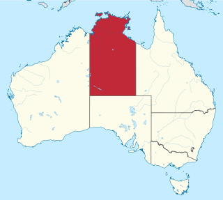
The Northern Territory is a federal Australian territory in the central and central northern regions of Australia. It is the third largest Australian federal division with an area of 1,348,094.3 square kilometres (520,502 sq mi) but the least populous with 247,327 inhabitants as at June 2018. The Northern Territory is divided administratively into 17 Local government areas (LGAs) generally known as Councils who are responsible for providing local government services.

Mount Hawthorn is a suburb of Perth, Western Australia, located within the City of Vincent.
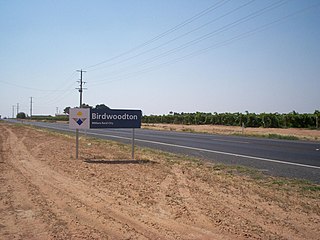
Birwoodton is a locality situated in the Sunraysia region, in north western Victoria, Australia. The place by road, is situated about 4 kilometres south of Merbein and 14 kilometres northwest of Mildura.

Ashford is an inner southwestern suburb of Adelaide, in the City of West Torrens. It is triangular in shape and bordered by South Road (west), Anzac Highway (southeast) and Everard Avenue (north). Two of the main features of the suburb are Ashford Hospital and Ashford Special School.

Glenelg North is a seaside suburb of Adelaide, South Australia. It is located in both the City of Holdfast Bay and the City of West Torrens.

Beerburrum is a small town and coastal locality in the Sunshine Coast Region, Queensland, Australia. In the 2016 census, Beerburrum had a population of 763 people.

Mango Hill is a suburb of the Moreton Bay Region, Queensland, Australia. Although locally known by this name since the 1950s, it wasn't until 1 September 1980 that it was formally decreed. The name Mango Hill was chosen to commemorate the section of Mango trees that were planted along the 700 metre section of Anzac Avenue that passes through the area.

Araluen is a rural locality in the Gympie Region, Queensland, Australia. In the 2016 census, Araluen had a population of 614 people.

Callington is a small town on the eastern slopes of the Adelaide Hills, in South Australia. Callington is situated on the Bremer River, and is adjacent to the South Eastern Freeway and the Adelaide-Wolseley railway line, however no trains have stopped at the station for many years. Callington is located within the state electoral district of Kavel and the federal division of Mayo.

Lascelles is a locality in Victoria, Australia, located approximately 113 km from Swan Hill, Victoria. In the 2016 census the state suburb of Lascelles had a population of 93.

Waitchie is a locality in Victoria, Australia, located approximately 44 km from Swan Hill, Victoria. At the 2006 census, Waitchie had a population of 118, decreasing to 48 at the 2016 census.

Wargan is a locality in Victoria, Australia, located approximately 26 km from Mildura, Victoria. At the 2006 census, Wargan had a population of 71.
Cooyar is a rural town and locality in the Toowoomba Region, Queensland, Australia. In the 2016 census, Cooyar had a population of 224 people.

Karara is a town and locality in the Darling Downs region within the Queensland, Australia. It is in the Southern Downs Region local government area. In the 2016 census, Karara had a population of 123 people.
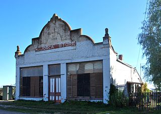
Majorca is a locality in central Victoria, Australia. The locality is in the Shire of Central Goldfields, 11 kilometres (6.8 mi) south of Maryborough and 171 kilometres (106 mi) north west of the state capital, Melbourne. At the 2006 census, Majorca and the surrounding rural area had a population of 387. By the time of the 2016 census the population had declined to 211.
Prince Henry Heights is a residential locality on the outskirts of Toowoomba in the Toowoomba Region, Queensland, Australia. In the 2016 census, Prince Henry Heights had a population of 571 people.

Bessiebelle is a locality in western Victoria, Australia. The locality is in the Shire of Moyne local government area, in what is commonly known as the Western District. Besiebelle is in the County of Normanby cadastral division, approximately 311 kilometres (193 mi) west of the state capital, Melbourne, on the Eumeralla River adjacent to the Mount Eccles National Park.

Lower Mount Walker is a locality split between the Scenic Rim Region and City of Ipswich local government areas of South East Queensland, Australia. In the 2016 census, Lower Mount Walker had a population of 185 people. In the 2016 census, Lower Mount Walker had a population of 185 people.
Anduramba is a rural locality in the Toowoomba Region, Queensland, Australia. In the 2016 census, Anduramba had a population of 77 people.

Pinery is a locality in South Australia's lower Mid North. At the 2006 census, Pinery had a population of 279 but the locality was included with the town of Owen in the 2011 census and residents were not counted separately.

