Brighton and Hove is a seaside city in East Sussex, in South East England. The towns of Brighton and Hove formed a unitary authority in 1997 and in 2001 were granted city status by Queen Elizabeth II. "Brighton" is often referred to synonymously with the official "Brighton and Hove" although many locals still consider the two to be separate towns. At the 2011 census, the city was England's most populous seaside resort, with a population of 273,400.

Juab County is a county in western Utah, United States. As of the 2010 United States Census, the population was 10,246. Its county seat and largest city is Nephi.

Shrewsbury is a town in Worcester County, Massachusetts, United States. Shrewsbury, unlike surrounding towns like Grafton, Millbury, Westborough, and Northborough, did not become a mill town or farming village; most of its 19th-century growth was due to its proximity to Worcester and visitors to Lake Quinsigamond. The population was 35,608 according to the 2010 US Census, in nearly 12,400 households.
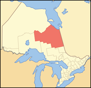
Cochrane District is a district and census division in Northeastern Ontario in the Canadian province of Ontario. It was created in 1921 from parts of Timiskaming and Thunder Bay districts.

An urban area or urban agglomeration is a human settlement with high population density and infrastructure of built environment. Urban areas are created through urbanization and are categorized by urban morphology as cities, towns, conurbations or suburbs. In urbanism, the term contrasts to rural areas such as villages and hamlets and in urban sociology or urban anthropology it contrasts with natural environment. The creation of early predecessors of urban areas during the urban revolution led to the creation of human civilization with modern urban planning, which along with other human activities such as exploitation of natural resources leads to human impact on the environment.

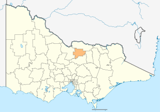
The City of Hawkesbury is a local government area of New South Wales, Australia, part of which is at the fringe of the Sydney metropolitan area, about 50 kilometres (31 mi) north-west of the Sydney central business district. Hawkesbury City is named after the Hawkesbury River.

Beaumont is a city in Leduc County within the Edmonton Metropolitan Region of Alberta, Canada. It is located at the intersection of Highway 625 and Highway 814, adjacent to the City of Edmonton and 6.0 kilometres (3.7 mi) northeast of the City of Leduc. The Nisku Industrial Park and the Edmonton International Airport are located 4.0 kilometres (2.5 mi) to the west and 8.0 kilometres (5.0 mi) to the southwest respectively.

Alicia, officially the Municipality of Alicia,, is a 4th class municipality in the province of Bohol, Philippines. According to the 2015 census, it has a population of 23,517 people.

Mabini, officially the Municipality of Mabini,, is a 4th class municipality in the province of Bohol, Philippines. According to the 2015 census, it has a population of 27,171 people.

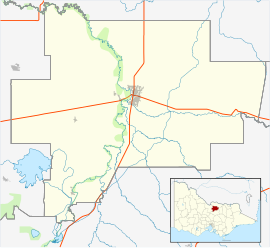
Bagpat district is one of the 75 districts of the Indian state of Uttar Pradesh with headquarters at the town of Baghpat. Created in 1997, the district has an area of 1,321 square kilometres (510 sq mi) and a population of 1,163,991.

Grande Cache is a hamlet within and administered by the Municipal District of Greenview No. 16 in west-central Alberta, Canada. It is located on Highway 40 approximately 145 kilometres (90 mi) northwest of Hinton and 435 kilometres (270 mi) west of Edmonton. Grande Cache overlooks the Smoky River, is at the northern edge of Alberta's Rockies, and serves as the gateway to the Willmore Wilderness Park. The hamlet held town status prior to 2019.

Valleyview is a town in northwest Alberta, Canada within the Municipal District of Greenview No. 16 and Census Division No. 18.

Kukerin is a small town in the Wheatbelt region of Western Australia, 308 kilometres (191 mi) south-east of Perth between Wagin and Lake Grace just off Dumbleyung Lake Grace Road on State Route 107. The town itself is small but services a considerable agricultural region in the eastern Shire of Dumbleyung. At the 2016 census, Kukerin and it's surrounding areas had a population of 166.

Matong is a town in the central east part of the Riverina region of New South Wales, Australia. The town is 37 kilometres (23 mi) east of Narrandera and 26 kilometres (16 mi) west of Coolamon. At the 2016 census, Matong had a population of 164 people.

Giddaluru is a census town in Prakasam district of the Indian state of Andhra Pradesh. It is the mandal headquarters of Giddaluru mandal in Markapur revenue division.