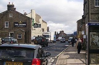
Hawes is a small market town and civil parish in Upper Wensleydale in the Richmondshire district of North Yorkshire, England, that was granted its market charter in 1699. Historically in the North Riding of Yorkshire, Hawes is located at the head of Wensleydale in the Yorkshire Dales; the River Ure runs to the north of the town and is regarded as one of the honeypot tourist attractions of the Yorkshire Dales National Park. It is known as the home to the Yorkshire Wensleydale Cheese.

Timboon is a town in the Western District of Victoria, Australia. The town is in the Shire of Corangamite local government area, approximately 213 kilometres (132 mi) south-west of the state capital, Melbourne. At the 2001 census, Timboon had a population of 787. At the 2006 census, Timboon had a population of 871. During the 2016 census Timboon had a population of 1,202.

Cambooya is a town and locality in the Toowoomba Region, Queensland, Australia. At the 2016 Australian census the town recorded a population of 1,584.

Nowie is a locality in Victoria, Australia, located approximately 26 km from Swan Hill, Victoria.

Balliang is a locality in Victoria, Australia. It is divided between the Shire of Moorabool and City of Greater Geelong local government areas. It lies north of Geelong and 54 kilometres (34 mi) from the state capital, Melbourne. At the 2016 census, Balliang had a population of 290.

Memerambi is a rural town and locality in the South Burnett Region, Queensland, Australia. In the 2016 census, Memerambi had a population of 272 people.

Brooloo is a town and locality in Gympie Region, Queensland, Australia.

Gladysdale is a bounded rural locality in Victoria, Australia, on the Yarra Junction Noojee Road. Its local government area is the Shire of Yarra Ranges. At the 2016 census, Gladysdale had a population of 444.
Burramine is a locality in the local government area of the Shire of Moira in Australia.
Burramine South is a locality in the Shire of Moira. Burramine South post office opened on 1 February 1882, closed on 17 December 1910, reopened on the 19 September 1911 and closed on 1 August 1952. Burramine South Creamery post office opened on the 1 July 1905 and was closed on 1 January 1918.

Wilkur is a town in the Mount Jeffcot ward of the local government area of the Shire of Buloke and the Warracknabeal ward of the Shire of Yarriambiack, Victoria, Australia. Wilkur post office there opened in 1905, closed on 30 September 1912 reopened on 1 February 1926 and later closed on 27 May 1950. Wilkur South post office opened on 28 June 1920 and was closed on 31 July 1957. Cameron's post office opened on 1 October 1904 renamed Beyal in April 1911 and was closed on 31 August 1929.
Nareewillock is a locality in the Lower Avoca ward of the local government area of the Shire of Buloke, Victoria, Australia.

Buckley is a rural locality in the Surf Coast Shire, Victoria, Australia. It was formerly known as Laketown. In the 2016 census, Buckley had a population of 211 people.

Worlds End is a locality 18 km southeast of Burra in South Australia. It also includes the area formerly known as Lapford.

Captains Mountain is a locality in the Toowoomba Region, Queensland, Australia. In the 2016 census, Captains Mountain had a population of 77 people.

Haly Creek is a locality in the South Burnett Region, Queensland, Australia.
Wondecla is a locality in the Tablelands Region, Queensland, Australia.
Kidaman Creek is a locality in the Sunshine Coast Region, Queensland, Australia.
Elbow Valley is a locality in the Southern Downs Region, Queensland, Australia. It borders New South Wales.
Bendoc is a locality in the Shire of East Gippsland, Victoria, Australia. It sits on the Bendoc River. In the 2016 census, Bendoc had a population of 115 people.
