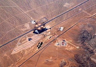
Jean is a small commercial town in Clark County, Nevada, United States, located approximately 12 mi (19 km) north of the Nevada–California state line along Interstate 15. Las Vegas is located about 30 mi (48 km) to the north. There are no residents of Jean, making it the least populated town in the United States, but many people in nearby communities such as Primm and Sandy Valley have Jean listed in their mailing address because it is the location of the main post office for the 89019 ZIP code. South Las Vegas Boulevard ends about 2 mi (3.2 km) south of Jean, and it contiguously runs northbound past Las Vegas, ending near the I-15–US 93 Junction.

Whitton is a small town located in Leeton Shire in the Australian state of New South Wales and is located 23km West of the Leeton township. Founded in 1850, it is named after John Whitton (1820–98), Engineer-in-Charge of the New South Wales Government Railways. The railway reached Whitton in 1881. At the 2016 census, Whitton had a population of 496.

Bungowannah is a locality in the Riverina region of New South Wales, Australia. The locality is on the Riverina Highway, about 16 kilometres (9.9 mi) north west of Albury and 8 kilometres (5.0 mi) south east of Howlong.

Wantabadgery is a village community in the central eastern part of the Riverina situated about 35 kilometres east of Wagga Wagga and 19 kilometres west of Nangus. At the 2011 census, Wantabadgery had a population of 299.
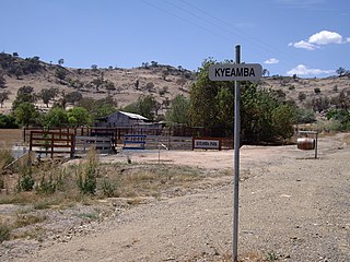
Kyeamba is a farming community in the central east part of the Riverina and situated about 16 kilometres (9.9 mi) north west of Humula and 23 kilometres (14 mi) south west of Tarcutta. At the 2016 census, Kyeamba had a population of 54.

Ournie is a rural community in the far south east part of the Riverina and situated about 15 kilometres north west from Welaregang and 20 kilometres south from Munderoo. Ournie is situated on the banks of the Ournie Creek which flows into the Murray River and the area is only about 4 kilometres from the border of Victoria.

Kamarah, is a village community in the central north part of the Riverina. It is situated by road, about 11 kilometres west of Ardlethan and 12 kilometres east of Moombooldool. At the 2006 census, Kamarah had a population of 130 people.
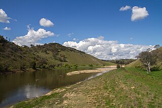
Cavan is a rural community situated on the south bank of the Murrumbidgee River in the Yass Valley Shire. At the 2016 census, it had a population of 47. It is situated by road, about 40 kilometres southwest of Yass and 43 northwest of Canberra. It was named after the town of Cavan in Ireland. It is reportedly owned by Rupert Murdoch.
Moira is a rural community in the central south part of the Riverina and the site of a railway station. It is situated by road, about 11 kilometres north of Barnes and 15 kilometres south west of Mathoura.

Linga is a locality situated on the section of the Mallee Highway and Pinnaroo railway line between Ouyen and the South Australian border in the Sunraysia region. It is situated about 8 kilometres east from Boinka and 11 kilometres west from Underbool.

Torrita is a locality situated on the section of the Mallee Highway and Pinnaroo railway line between Ouyen and the South Australian border in the Sunraysia region. The place by road, is situated about 13 kilometres east from Underbool and 8 kilometres west from Walpeup.

Invergordon is a town in northern Victoria, Australia.
Marinna is a locality in Junee Shire in southern New South Wales, Australia. Its main feature is a grain silo on the Main South railway line. A station was opened in the locality between 1897 and 1975.
Wilkur is a locality in the Mount Jeffcot ward of the local government area of the Shire of Buloke and the Warracknabeal ward of the Shire of Yarriambiack, Victoria, Australia. Wilkur post office there opened in 1905, closed on 30 September 1912 reopened on 1 February 1926 and later closed on 27 May 1950. Wilkur South post office opened on 28 June 1920 and was closed on 31 July 1957. Cameron's post office opened on 1 October 1904 renamed Beyal in April 1911 and was closed on 31 August 1929.
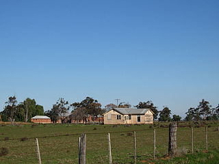
Maidenwell is a rural town and locality in the South Burnett Region, Queensland, Australia. In the 2016 census the locality of Maidenwell had a population of 199 people.
Julia is a locality in the Mid North of South Australia, 111 kilometres North of Adelaide, the state capital. The town is located 10 kilometres (6.2 mi) north of Eudunda, in the Regional Council of Goyder. It was created in August 2000, with boundaries formalised for the long established local name.
Franklyn is a rural locality in the Mid North region of South Australia, situated in the Regional Council of Goyder. It was established in August 2000, when boundaries were formalised for the "long established local name". It comprises the northern section of the cadastral Hundred of Wonna. The name stems from a Franklyn House in Devonshire.

Canowie Belt is a rural locality in the Mid North region of South Australia, situated in the Regional Council of Goyder. It was established in August 2000, when boundaries were formalised for the "long established local name". The name is adapted from "Kanya-owie", an Aboriginal word for "rock waterhole", and was associated with the Canowie Station pastoral lease.
Frankton is a rural locality in the Mid North region of South Australia, situated in the Regional Council of Goyder and Mid Murray Council. The section within the Goyder council was established in August 2000, when boundaries were formalised for the "long established local name"; the section within the Mid Murray council was added in March 2003. It is believed to be named after the son of two early residents, Mr. and Mrs. Rice.
Hampden is a rural locality in the Mid North region of South Australia, situated in the Regional Council of Goyder. It was established in August 2000, when boundaries were formalised for the "long established local name". It was named for William Hampden Dutton, brother of Frederick Dutton, who established Anlaby Station.
