
Alexander County is a county established in the U.S. state of North Carolina in 1847. As of the 2010 census, the population was 37,198. Its county seat is Taylorsville.

North Yorkshire is the largest non-metropolitan county and lieutenancy area in England, covering an area of 8,654 square kilometres (3,341 sq mi). Around 40% of the county is covered by national parks, including most of the Yorkshire Dales and the North York Moors. It is one of four counties in England to hold the name Yorkshire; the three other counties are the East Riding of Yorkshire, South Yorkshire and West Yorkshire.

Notre Dame is a census-designated place north of the city of South Bend in St. Joseph County, in the U.S. state of Indiana. It includes the campuses of three colleges: the University of Notre Dame, Saint Mary's College, and Holy Cross College. Notre Dame is split between Clay and Portage Townships. As of the 2020 census, its population was 6,342.

Ichapore or Ichhapur is a locality in North Barrackpur Municipality of North 24 Parganas district in the Indian state of West Bengal. It is a part of the area covered by Kolkata Metropolitan Development Authority (KMDA). Ichhapur Defence Estate has two ordnance factories, the Rifle Factory Ishapore (RFI) and the Metal and Steel Factory (MSF) of the Ordnance Factories Board.

Allendale is a town in Victoria, Australia, located north-east of Creswick, in the Shire of Hepburn. At the 2016 census, Allendale and the surrounding area had a population of 166.
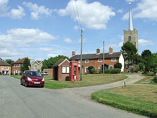
Middleton is a village in the east of the English county of Suffolk. It is located approximately 3 miles (5 km) north-west of Leiston, 5 miles (8 km) north east of Saxmundham and 3 miles (5 km) from the Suffolk coast. The village is on the B1122 around 2 miles (3 km) east of Yoxford and had a population of 359 at the 2001 census, falling to 343 at the 2011 Census.
North Barrackpur is a city and a municipality of North 24 Parganas district in the Indian state of West Bengal. It is a part of the area covered by Kolkata Metropolitan Development Authority (KMDA).

North Dum Dum is a city and a municipality of North 24 Parganas district in the Indian state of West Bengal. It is close to Kolkata and also a part of the area covered by Kolkata Metropolitan Development Authority (KMDA).
South Dum Dum is a city and a municipality of North 24 Parganas district in the Indian state of West Bengal. It is close to Kolkata and also a part of the area covered by Kolkata Metropolitan Development Authority (KMDA).

Collingullie is a village 26 kilometres (16 mi) north-west of Wagga Wagga in the Riverina region of New South Wales, Australia. The village is located on the Sturt Highway, between Wagga Wagga and Narrandera, at the crossroads with the road to Lockhart.

Patchewollock is a town in north-west Victoria, Australia. At the 2016 census, Patchewollock had a population of 133.

Tamworth Regional Council is a local government area in the New England region of New South Wales, Australia. The area under administration is located adjacent to the New England Highway and the Main North railway line. It was established in March 2004 through the amalgamation of the former City of Tamworth with surrounding shires of Barraba, Manilla, Nundle and Parry.

Burraboi is a community in New South Wales, Australia. It is in the southwestern part of the Riverina and situated about 34 kilometres (21 mi) north of Barham and 50 km south of Moulamein. At the 2016 census, Burraboi had a population of 63.

Woolgarlo is a locality on the foreshores of the Yass River arm of Lake Burrinjuck, in the far eastern part of the Riverina in the Yass Valley Shire of New South Wales, Australia. At the 2016 census, it had a population of 26.

Womboota is a locality in the centre south part of the Riverina. It is situated by road, about 26 kilometres (16 mi) north from Moama and 28 kilometres (17 mi) south west from Bunnaloo. At the 2016 census, Womboota had a population of 105.

Peranga is a rural town and locality in the Toowoomba Region, Queensland, Australia. In the 2016 census the locality of Peranga had a population of 85 people.

The Shire of Tungamah was a local government area in the Goulburn Valley region about 240 kilometres (149 mi) northeast of Melbourne, the state capital of Victoria, Australia. The shire covered an area of 1,143 square kilometres (441.3 sq mi), and existed from 1878 until 1994.

Karara is a town and locality in the Darling Downs region within the Queensland, Australia. It is in the Southern Downs Region local government area. In the 2016 census, Karara had a population of 123 people.

Bududa District is a district in the Eastern Region of Uganda. Bududa is the chief town of the district.

Glen Huon is a rural residential locality in the local government area of Huon Valley in the South-east region of Tasmania. It is located about 10 kilometres (6.2 mi) west of the town of Huonville. The 2016 census has a population of 661 for the state suburb of Glen Huon.
