Picola

Last updated

Picola
Victoria
Picola 2011 002.JPG
Picola
Australia Victoria Moira Shire location map.svg
Red pog.svg
Picola
Coordinates 36°00′0″S145°08′0″E / 36.00000°S 145.13333°E / -36.00000; 145.13333
Population334 (2011 census) [1]
Postcode(s) 3639
Location
LGA(s) Shire of Moira
State electorate(s) Shepparton
Federal division(s) Nicholls
Localities around Picola:
Barmah New South Wales New South Wales
Picola West Picola Yeilima
Lower Moira Kotupna Nathalia
Picola Hotel in 2007 PicolaHotel2.JPG
Picola Hotel in 2007

Picola is a town in the Shire of Moira in northern Victoria, Australia. At the 2021 census, Picola had a population of 206. [2]

Contents

History

Picola Hall in 2011 Picola Hall.JPG
Picola Hall in 2011

The name Picola is thought to derive from an Aboriginal word for either rushing water or an Aboriginal sub-group. [3] During the 1800s, the towns of Picola and Nathalia competed for farmland selection. Picola was close to the coach route from Echuca to Tocumwal and had a general store, a Union Church and a primary school which was established in 1879. However, Picola fell behind, likely due to its lack of a substantial watercourse compared to Nathalia's position on the Broken Creek. [3]

Picola Post Office opened on 24 August 1878 and closed in late 2010. The Australia Post outlet was then taken over by the Picola Hotel, until early 2011. [4]

On 15 December 1896, the railway line was extended from Nathalia to Picola. [5] It closed on 8 December 1986. [6] It was used to transport wheat, livestock and red gum from the Barmah National Park. [3] [7] The town was once known as 'the hook' because it was at the end of a railway line. [8]

Federal Hall was established in 1900, later known as Picola Memorial Hall and Picola Public Hall. It has been burnt down and rebuilt twice: on 19 August 1936, leading the wooden building to be replaced by a brick structure, and on 12 April 1939. [9] [10] [11] Water was carted from Broken Creek until a town dam and water tank was constructed in 1950. [3] A book about the history of the hall was written by Jeanette Holland in 2010. [12]

After the silo art project in Picola was completed in December 2020 as part of the Silo Art Trail, Picola has experienced a tourism boom, leading to owner Bruce Agnew refurbishing and reopening the Picola Hotel on 17 November 2021. Painted by Jimmy Dvate, it features flora and fauna from the Barmah National Park. There are plans to paint a second mural. [8] [13] [14]

Picola has a mixture of irrigated, wheat and timber milling farms. At the 2011 census, farming accounted for 37.2% of employment, with 9.9% dairy farming. [3]

Arts and culture

Picola Public Hall hosts a monthly old-time dance featuring local bands and musicians, as well as themed dances during holidays. [9]

Transportation

Picola is serviced by two return V/Line coach services on weekdays originating in Barmah: both connect in Shepparton, with train services to Melbourne Southern Cross station. The Picola Hotel serves as the ticket agency. [15]

Sport

The town is home to Picola United Football Club competing in the Picola & District Football League, and the Picola Bowls Club, competing in the Murray Bowls Association.

Related Research Articles

<span class="mw-page-title-main">Shepparton</span> City in Victoria, Australia

Shepparton is a city located on the floodplain of the Goulburn River in northern Victoria, Australia, approximately 181 kilometres (112 mi) north-northeast of Melbourne. As of the 2021 census, the estimated population of Shepparton, including the adjacent town of Mooroopna, was 53,841.

<span class="mw-page-title-main">Tocumwal</span> Town in New South Wales, Australia

Tocumwal is a town in the southern Murray region of New South Wales, Australia, in the Berrigan Shire local government area. The town, 270 kilometres (170 mi) north of the city of Melbourne, lies on the northern bank of the Murray River, which forms the border with Victoria.

<span class="mw-page-title-main">Strathmerton</span> Town in Victoria, Australia

Strathmerton is a town in Victoria, Australia.

<span class="mw-page-title-main">Wallan</span> Town in Victoria, Australia

Wallan, traditionally known as Wallan Wallan, is a town in Victoria, 45 kilometres (28 mi) north of Melbourne's Central Business District. The town sits at the southern end of the large and diverse Shire of Mitchell which extends from the northern fringes of Melbourne into the farming country of north-central Victoria and the lower Goulburn Valley. The township flanks the Hume Freeway and is set against the backdrop of the Great Dividing Range. At the 2021 census it had a population 15,004.

<span class="mw-page-title-main">Numurkah</span> Town in Victoria, Australia

Numurkah is a town in Victoria, Australia, located on the Goulburn Valley Highway, 37 kilometres (23 mi) north of Shepparton, in the Shire of Moira. At the 2016 census, Numurkah had a population of 4,768.

<span class="mw-page-title-main">Nathalia, Victoria</span> Town in Victoria, Australia

Nathalia is a town in northern Victoria, Australia. The town is located within the Shire of Moira local government area on the banks of Broken Creek and on the Murray Valley Highway. At the 2021 census, Nathalia had a population of 1,982.

<span class="mw-page-title-main">Picola & District Football Netball League</span>

The Picola & District Football Netball League is an Australian rules football and netball league affiliated with the AFL Victoria Country.

<i>Alexander Arbuthnot</i> (paddle steamer)

The Alexander Arbuthnot is the last paddle steamer built as a working boat during the riverboat trade era on the Murray River, Australia.

<span class="mw-page-title-main">Katamatite</span> Town in Victoria, Australia

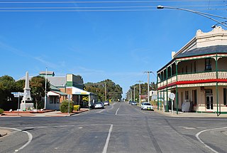
Katamatite is a town in Victoria, Australia about 46 kilometres north east of Shepparton. At the 2011 census, Katamatite had a population of 433.

<span class="mw-page-title-main">Sea Lake</span> Town in Victoria, Australia

Sea Lake is a town in the Mallee district of north-west Victoria, Australia and is situated on the southern shores of Lake Tyrrell. The town is located on the Calder Highway, 351 kilometres (218 mi) north-west of Melbourne, and 73 kilometres (45 mi) west of Swan Hill. Sea Lake is in the heart of Australia's wheat belt, and is the main township for a number of wheat farms in the region. At the 2021 census, Sea Lake had a population of 619.

<span class="mw-page-title-main">Katamatite Football Club</span> Australian rules football and netball club

The Katamatite Football Netball Club, nicknamed the Tigers, is an Australian rules football and netball club based in the small Victorian town of Katamatite.

<span class="mw-page-title-main">Murray Football Netball League</span>

The Murray Football Netball League is an Australian rules football and netball league affiliated with the Victorian Country Football League. The league covers a large area of northern Victoria and southern New South Wales from Shepparton in the south to Deniliquin in the north.

The Nathalia Football Netball Club, nicknamed the Purples, is an Australian rules football and netball club based in the town of Nathalia located in north east Victoria. The club currently compete in the Murray League, which Nathalia joined in 1931.

<span class="mw-page-title-main">Tungamah</span> Town in Victoria, Australia

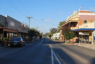
Tungamah is a town in the Goulburn Valley region of northern Victoria, Australia. The town is located in the Shire of Moira local government area, 259 kilometres (161 mi) from the state capital, Melbourne. Tungamah is situated on the banks of Boosey Creek and at the 2006 census, Tungamah had a population of 355.

<span class="mw-page-title-main">Wunghnu</span> Town in Victoria, Australia

Wunghnu is a town in the Goulburn Valley region of northern Victoria, Australia. The town is located in the Shire of Moira local government area, 204 kilometres (127 mi) north of the state capital, Melbourne. The local railway station was opened on the Goulburn Valley railway in 1881, but does not see any passenger services, being the site of a siding and grain silos.

<span class="mw-page-title-main">Dookie, Victoria</span> Town in Victoria, Australia

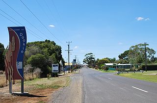
Dookie (/ˈduːki/) is a town in the Goulburn Valley region of Victoria, Australia. It is situated in a valley between Mount Major and Mount Saddleback. Dookie is a farming community. At the 2021 census, Dookie had a population of 333.

<span class="mw-page-title-main">Electoral district of Shepparton</span> State electoral district of Victoria, Australia

The electoral district of Shepparton is a rural Lower House electoral district of the Victorian Parliament. It is located within the Northern Victoria Region of the Legislative Council.

<span class="mw-page-title-main">Shire of Nathalia</span> Local government area in Victoria, Australia

The Shire of Nathalia was a local government area on the Murray River in the Goulburn Valley region, about 220 kilometres (137 mi) north of Melbourne, the state capital of Victoria, Australia. The shire covered an area of 1,238.97 square kilometres (478.4 sq mi), and existed from 1879 until 1994.

<span class="mw-page-title-main">Numurkah railway station</span> Former railway station in Victoria, Australia

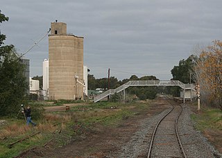
Numurkah is a closed railway station on the Goulburn Valley railway line, which once served the town of the same name, in Victoria, Australia.

<span class="mw-page-title-main">Youanmite</span> Town in Victoria, Australia

Youanmite is a locality in the Shire of Moira. It is located near the intersection of Youanmite and Katamatite roads, approximately 25 km southwest of Yarrawonga and approximately 200 km northeast of Melbourne, Australia. Youanmite was once a small town having its own schools, churches, and post office. Comprising medium to large farms the area is predominantly agricultural, focusing on grain production as well as sheep and cattle grazing.

References

  1. Australian Bureau of Statistics (31 October 2012). "Picola (State Suburb)". 2011 Census QuickStats. Retrieved 5 December 2014. OOjs UI icon edit-ltr-progressive.svg
  2. Australian Bureau of Statistics (28 June 2022). "Picola". 2021 Census QuickStats. Retrieved 5 February 2023. OOjs UI icon edit-ltr-progressive.svg
  3. 1 2 3 4 5 "Picola". Victorian Places. Retrieved 4 February 2023.
  4. Premier Postal History. "Post Office List" . Retrieved 11 April 2008.
  5. "THE NATHALIA-PICOLA RAILWAY". The Argus . 16 December 1896. p. 6. Retrieved 5 February 2023 via Trove.
  6. "VR Timeline". victorianrailways.net. Retrieved 5 April 2016.
  7. "Picola, Victoria". Travelmate. Archived from the original on 4 August 2007.
  8. 1 2 "Creative project lifts regional town". Creative Victoria. 10 January 2023. Retrieved 5 February 2023.
  9. 1 2 Holland, Jeanette (2010). A history of Picola Hall : 110 years and still dancing : 1900 - 2010. ISBN   9780646540733.
  10. "Picola Public Hall Burnt". The Age . 20 August 1936. p. 10. Retrieved 5 February 2023 via Trove.
  11. "FIRE AT PICOLA". The Riverine Herald. 14 April 1939. p. 2. Retrieved 5 February 2023 via Trove.
  12. "BOOKS RECEIVED" (PDF). History News. No. 295. Royal Historical Society of Victoria. 2011. p. 4. Retrieved 5 February 2023.
  13. Francis, Gianni (23 November 2021). "Picola Hotel revamped and reopened" . Shepparton News . Retrieved 5 February 2023.
  14. Howe, Courtney (10 September 2022). "Melburnians urged to take silo art road trip through tiny towns in northern Victoria". ABC News . Retrieved 5 February 2023.
  15. "Barmah". V/Line . Retrieved 5 February 2023.