The Murray River is a river in Southeastern Australia. It is Australia's longest river at 2,508 km (1,558 mi) extent. Its tributaries include five of the next six longest rivers of Australia. Together with that of the Murray, the catchments of these rivers form the Murray–Darling basin, which covers about one-seventh the area of Australia. It is widely considered Australia's most important irrigated region.
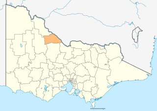
The Shire of Gannawarra is a local government area in Victoria, Australia, located in the northern part of the state. It covers an area of 3,735 square kilometres (1,442 sq mi) and, in August 2021 had a population of 10,683.
Ross River virus (RRV) is a small encapsulated single-strand RNA Alphavirus endemic to Australia, Papua New Guinea and other islands in the South Pacific. It is responsible for a type of mosquito-borne, non-lethal but extremely debilitating tropical disease known as Ross River fever, previously termed "epidemic polyarthritis". There is no known cure, and it can last in the host's system for up to 20 years. The virus is suspected to be enzootic in populations of various native Australian mammals, and has been found on occasion in horses.
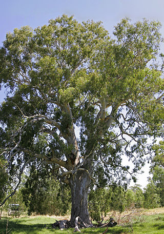
Eucalyptus camaldulensis, commonly known as the river red gum, of flowering plant in the family Myrtaceae, and is endemic to Australia. It is a tree with smooth white or cream-coloured bark, lance-shaped or curved adult leaves, flower buds in groups of seven or nine, white flowers and hemispherical fruit with the valves extending beyond the rim. A familiar and iconic tree, it is seen along many watercourses across inland Australia, providing shade in the extreme temperatures of central Australia and elsewhere.
Ross River fever is a mosquito-borne infectious disease caused by infection with the Ross River virus. The illness is typically characterised by flu like symptoms combined with polyarthritis and a rash. The virus is endemic to mainland Australia and Tasmania, the island of New Guinea, Fiji, Samoa, the Cook Islands, New Caledonia and several other islands in the South Pacific. The illness is Queensland's most prolific mosquito-borne disease.
Murray Valley encephalitis virus (MVEV) is a zoonotic flavivirus endemic to northern Australia and Papua New Guinea. It is the causal agent of Murray Valley encephalitis. In humans, it can cause permanent neurological disease or death. MVEV is related to Kunjin virus, which has a similar ecology, but a lower morbidity rate. Although the arbovirus is endemic to Northern Australia, it has occasionally spread to the southern states during times of heavy rainfall during the summer monsoon season via seasonal flooding of the Murray-Darling River system. These outbreaks can be "...decades apart, with no or very few cases identified in between".
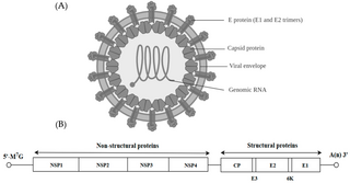
Alphavirus is a genus of RNA viruses, the sole genus in the Togaviridae family. Alphaviruses belong to group IV of the Baltimore classification of viruses, with a positive-sense, single-stranded RNA genome. There are 32 alphavirus species, which infect various vertebrates such as humans, rodents, fish, birds, and larger mammals such as horses, as well as invertebrates. Alphaviruses that can infect both vertebrates and arthropods are referred dual-host alphaviruses, while insect-specific alphaviruses such as Eilat virus and Yada yada virus are restricted to their competent arthropod vector. Transmission between species and their vertebrate hosts occurs mainly via mosquitoes, making the alphaviruses a member of the collection of arboviruses – or arthropod-borne viruses. Alphavirus particles are enveloped, have a 70 nm diameter, tend to be spherical, and have a 40 nm isometric nucleocapsid.

Barmah Forest virus is an RNA virus in the genus Alphavirus. This disease was named after the Barmah Forest in the northern Victoria region of Australia, where it was first isolated in 1974. It is passed to vertebrate hosts almost exclusively by mosquitoes, the first case in humans being documented in 1986. As of 2023, it is widespread in Australia and there is some evidence of local transmission in Papua New Guinea.

Nathalia is a town in northern Victoria, Australia. The town is located within the Shire of Moira local government area on the banks of Broken Creek and on the Murray Valley Highway. At the 2021 census, Nathalia had a population of 1,982.
Ulupna Island, a river island, lies at the eastern end of Barmah National Park which is a part of the largest river red gum forest in Victoria, Australia. The island is bounded by the Murray River and its anabranch, Ulupna Creek. Ulupna Island is part of the flood plain of the Murray River.

The Alexander Arbuthnot is the last paddle steamer built as a working boat during the riverboat trade era on the Murray River, Australia.

Barham is a town in the western Riverina district of New South Wales, Australia. The town is located 823 kilometres south west of the state capital, Sydney and 303 kilometres north west of Melbourne. Situated on the banks of the Murray River across from Koondrook in the neighbouring state of Victoria, Barham had a population of 1,159 at the 2016 census. The town is in the Murray River Council local government area.

Koondrook is a town situated on the Murray River, Victoria, Australia. The town is located in the Shire of Gannawarra local government area, 301 kilometres (187 mi) north west of the state capital, Melbourne. At the 2016 census, Koondrook had a population of 832.

The Yorta Yorta, also known as Jotijota, are an Aboriginal Australian people who have traditionally inhabited the area surrounding the junction of the Goulburn and Murray Rivers in present-day north-eastern Victoria and southern New South Wales.

Culex annulirostris, commonly known as the common banded mosquito, is an insect native to Australia, Fiji, Micronesia, the Philippines and Indonesia. It is regarded as a serious pest species throughout its range.

The Barmah National Park, formerly Barmah State Park, is a national park located in the Hume region of the Australian state of Victoria. The park is located adjacent to the Murray River near the town of Barmah, approximately 225 kilometres (140 mi) north of Melbourne. The park consists of river red gum floodplain forest, interspersed with treeless freshwater marshes. The area is subject to seasonal flooding from natural and irrigation water flows.
Murray Valley National Park is a national park in the Riverina region of New South Wales, Australia. The national park consists of 41,601 hectares.

The Barmah-Millewa Important Bird Area is a 2635 km2 tract of land in south-eastern Australia which has been identified by BirdLife International as an Important Bird Area (IBA) because of its significance for the conservation of a range of bird species.

The Cadell Fault is a north-south trending intra-plate geological fault in the Riverina area of New South Wales and Victoria, in Australia. It straddles the Murray River and, in quite recent geological times, has affected its course, as well as the courses of the Edward River, Wakool River, Goulburn River and Campaspe River. The Cadell Fault is notable due to that impact and has been described as one of the most significant examples of seismic activity changing the course of rivers. The fault is visible as a continuous earthen ridge along the Cobb Highway between Deniliquin and Echuca, and extends further south into Victoria. The fault is likely named after Francis Cadell, an early European pioneer of the Murray River and river trader.

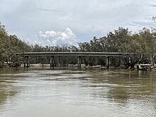
The Tooleybuc Bridge is a dual heritage-listed road bridge that carries Tooleybuc Road across the Murray River, located in Tooleybuc, New South Wales, Australia. It was built in 1925. The bridge is owned by the Transport for NSW, and is also called the Tooleybuc Bridge over Murray River. The bridge was added to the New South Wales State Heritage Register on 20 June 2000 and the Victorian Heritage Register on 10 July 2008.