
The almond is a species of tree native to Iran and surrounding countries and ancient remains of almonds were discovered in the Levant area. The almond is also the name of the edible and widely cultivated seed of this tree. Within the genus Prunus, it is classified with the peach in the subgenus Amygdalus, distinguished from the other subgenera by corrugations on the shell (endocarp) surrounding the seed.
Nangiloc is a small rural community in North Western Victoria on the south (left) bank of the Murray River, about 50 km south east of Mildura. Primarily an agricultural settlement, at the 2016 census, Nangiloc and the surrounding area had a population of 141.
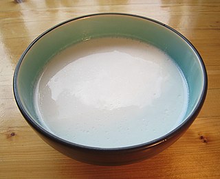
Plant milk is a plant beverage with a color resembling that of milk. Plant milks are non-dairy beverages made from a water-based plant extract for flavoring and aroma. Plant milks are consumed as alternatives to milk, and often provide a creamy mouthfeel. By 2021, among around 17 plants are used to manufacture plant milk, almond, oat, soy, and coconut were the highest-selling plant milks worldwide.

Cressy is a town in Victoria, Australia, approximately 38 kilometres (24 mi) north of Colac on the Ballarat road. It is divided between Golden Plains Shire, the Shire of Colac Otway, and Corangamite Shire. At the 2016 census, Cressy and the surrounding area had a population of 175.

Colignan is a small rural town on the banks of the Murray River, in North Western Victoria, Australia. The town is on the border of the Hattah-Kulkyne National Park. At the 2016 census, Colignan and the surrounding area had a population of 329.

Bungowannah is a locality in the Riverina region of New South Wales, Australia. The locality is on the Riverina Highway, about 16 kilometres (9.9 mi) north west of Albury and 8 kilometres (5.0 mi) south east of Howlong.

Carina is a locality in the Rural City of Mildura in Victoria, Australia. It is situated in the Sunraysia region on the Mallee Highway and Pinnaroo railway line. It is situated about 10 kilometres east from Panitya and 14 kilometres west from Murrayville.

Benaraby is a rural town and locality in the Gladstone Region, Queensland, Australia. In the 2016 census the locality of Benaraby had a population of 1,219 people.
Mittyack is a locality in Victoria, Australia, located approximately 37 km from Ouyen on the Calder Highway.
Burrumbeet is a town in western Victoria, Australia. The town is located on the Western Highway, 136 kilometres (85 mi) west of the state capital, Melbourne and 24 kilometres (15 mi) west of the regional centre, Ballarat. At the 2016 census, Burrumbeet and the surrounding area had a population of 232.

Yalca is a locality in northern Victoria, Australia in the local government area of the Shire of Moira. At the 2011 census, Yalca had a population of 301.

Mywee is a locality in northern Victoria, Australia. It is in the local government area of Shire of Moira. Mywee was also known as "Sheepwash Creek".
Burramine is a locality in the local government area of the Shire of Moira in Australia.
Almond is an unincorporated community in Swain County, North Carolina, United States. Almond is located on the Little Tennessee River and North Carolina Highway 28 7.9 miles (12.7 km) west-southwest of Bryson City.
Joskeleigh is a coastal rural locality in the Livingstone Shire, Queensland, Australia. In the 2016 census Joskeleigh had a population of 70 people.
Bouldercombe is a rural town and locality in the Rockhampton Region, Queensland, Australia. In the 2016 census, the locality of Bouldercombe had a population of 1,085 people.

Aubigny is a rural town and locality in the Toowoomba Region, Queensland, Australia. In the 2016 census, Aubigny had a population of 254 people.

Hoskinstown is a locality in Queanbeyan-Palerang Regional Council, New South Wales, Australia. The locality, and what remains of the cluster of settlement of the same name, is 38 km southeast of Canberra the Capital city of Australia, and 299 km southwest of Sydney. At the 2016 census, it had a population of 189.
Frankton is a rural locality in the Mid North region of South Australia, situated in the Regional Council of Goyder and Mid Murray Council. The section within the Goyder council was established in August 2000, when boundaries were formalised for the "long established local name"; the section within the Mid Murray council was added in March 2003. It is believed to be named after the son of two early residents, Mr. and Mrs. Rice.
Cliff Almond was a former Australian professional soccer player who played as a forward. He was an international player for the Australia national soccer team.
