Benalla is a small city located on the Broken River gateway to the High Country north-eastern region of Victoria, Australia, about 212 kilometres (130 mi) north east of the state capital Melbourne. At the 2016 census the population was 9,298.
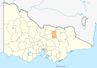
The Rural City of Benalla is a local government area in the Hume region of Victoria, Australia, located in the north-east part of the state. It covers an area of 2,353 square kilometres (908 sq mi) and, in June 2018, had a population of 14,024.

Healesville is a town in Victoria, Australia, 52 km north-east from Melbourne's central business district. Its local government area is the Shire of Yarra Ranges. At the 2016 Census, Healesville had a population of 7,461. The median age was 44 years.

Violet Town is a town in northeastern Victoria, Australia. The town is in the Shire of Strathbogie local government area, 174 kilometres (108 mi) northeast of the state capital, Melbourne on the Hume Highway. At the 2016 census, Violet Town and district had a population of 1,540.
Cobram is a town in the Australian state of Victoria. It is on the Murray River which forms the border between Victoria and New South Wales. Cobram along with the nearby towns of Numurkah and Yarrawonga is part of Shire of Moira and is the administrative centre of the council. Its twin town of Barooga is located on the north side of the Murray River. Surrounding Cobram are a number of orchards, dairy farms and wineries. At the 2016 census, Cobram had a population of 6,014. Barooga's population is currently 1,817.

Yarrawonga is a town in the Shire of Moira local government area in the Australian state of Victoria. The town is situated on the south bank of the Murray River, the border between Victoria and New South Wales and is located approximately 265 kilometres (165 mi) north-east of the state capital, Melbourne. Yarrawonga's twin town of Mulwala is on the other side of the Murray River. At the 2016 census, Yarrawonga had a population of 7,930.

Cowwarr is a town in Victoria, Australia, 27 kilometres north-east of Traralgon, 174 kilometres east of Melbourne, in the Shire of Wellington. At the 2016 census, Cowwarr and the surrounding area had a population of 368.

Nathalia is a town in northern Victoria, Australia. The town is located within the Shire of Moira local government area on the banks of Broken Creek and on the Murray Valley Highway. At the 2011 census, Nathalia had a population of 1,902.
Lockhart is a town in the Riverina Region of New South Wales, Australia. It is the location of the Lockhart Shire Council offices. At the 2016 census, Lockhart had a population of 818 people.
Barellan is a small town in Narrandera Shire in the Riverina region of New South Wales, Australia. On Census night 2016, Barellan had declined to a population of 538. It is a quiet Riverina wheat town on the Burley Griffin Way, with characteristic silos, and functions primarily as a service centre for the surrounding agricultural area.

Katunga is a town in the Goulburn Valley region of northern Victoria, Australia. The town is located in the Shire of Moira local government area, 228 kilometres from the state capital, Melbourne. At the 2016 census, Katunga had a population of 996.

Wunghnu is a small town in the Goulburn Valley region of northern Victoria, Australia. The town is located in the Shire of Moira local government area, 204 kilometres (127 mi) north of the state capital, Melbourne. The local railway station was opened on the Goulburn Valley railway in 1881, but does not see any passenger services, being the site of a siding and grain silos.

Rupanyup is a small town in rural Victoria, Australia. As of the 2016 census, it had a population of 536. The name Rupanyup is an Aboriginal word meaning 'branch hanging over water'.

Picola is a town in northern Victoria, Australia. The town is located in the Shire of Moira local government area, 246 kilometres (153 mi) from the state capital, Melbourne. At the 2011 census, Picola had a population of 334.

Waaia is a town in northern Victoria, Australia in the Shire of Moira local government area, 228 kilometres (142 mi) north of the state capital, Melbourne. The area is home to mainly irrigated dairy farms. At the 2011 census, Waaia and the surrounding area had a population of 376.

St James is a town in northern Victoria, Australia. The town is located in the Shire of Moira local government area, 238 kilometres (148 mi) north of the state capital, Melbourne. At the 2016 census, St James had a population of 132.

Devenish is a town in northern Victoria, Australia within the Rural City of Benalla local government area, 230 kilometres (143 mi) north of the state capital, Melbourne. At the 2011 census, Devenish and the surrounding area had a population of 360, declining to 197 by 2016.

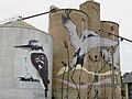
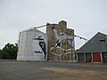
Goorambat is a town in northern Victoria, Australia. The town is located in the Rural City of Benalla local government area, 229 kilometres (142 mi) north of the state capital, Melbourne. At the 2016 census, Goorambat and the surrounding area had a population of 297.

Brim is a small town in the Wimmera region of Victoria, Australia. The town is located 359 kilometres (223 mi) north west of the state capital, Melbourne on the Henty Highway. It is on the banks of the Yarriambiack Creek. It is in the Shire of Yarriambiack local government area. At the 2016 census, Brim had a population of 171.
The Katamatite railway line is a disused railway located in northern Victoria, Australia. It was built as a tramway, running from Dookie to Katamatite, and opened on 11 August 1890. Two years later it was taken over by the Victorian Railways (VR) and sections of the track were upgraded allowing its reclassification as a railway. The line was formally closed on 13 January 1987.