
Forest Hill is a suburb of Melbourne, Victoria, Australia, 18 km east of Melbourne's Central Business District, located within the City of Whitehorse local government area. Forest Hill recorded a population of 10,780 at the 2021 census.
Joel Joel is an agricultural community located 23 km east of Stawell in the Wimmera region of Victoria, Australia. It comprises a small village centre of scattered houses and larger farms.

Mount Cottrell is a town in Victoria, Australia, 31 km (19 mi) west of Melbourne's Central Business District, located within the Cities of Melton and Wyndham local government areas. Mount Cottrell recorded a population of 496 at the 2021 census.

Waratah is a locality and town in North Western Tasmania adjacent to Savage River National Park. The town was constructed to support a tin mine at Mount Bischoff. It is built at the top of a waterfall, and water was diverted from the stream to provide water for mine sluicing and processing. At the 2021 census, Waratah had a population of 249. It was also the first town in Australia to have electric street lights in 1886.

Ournie is a rural community in the far south east part of the Riverina and situated about 15 kilometres north west from Welaregang and 20 kilometres south from Munderoo. Ournie is situated on the banks of the Ournie Creek which flows into the Murray River and the area is only about 4 kilometres from the border of Victoria.

Carabost is a foresting community in the south-east part of the Riverina. It is situated about 16 kilometres north west of Rosewood and 22 kilometres south east of Kyeamba.
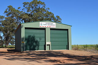
Colinroobie is a rural community in the central part of the Riverina in southern New South Wales, Australia. Previously referred to as Bents Hill its name was changed in January 2005.

Corobimilla is a village locality in the central east part of the Riverina. It is situated by road, about 12 kilometres northeast of Morundah and 20 kilometres south west of Narrandera.

Lankeys Creek is a rural community in the east part of the Riverina. It is situated by road, about 18 kilometres north west of Jingellic and 36 kilometres south east of Holbrook.
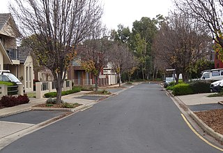
Underdale is a western suburb of South Australia's capital city Adelaide on Kaurna land. It sits between Henley Beach Road and the River Torrens. It is largely residential with a very small industrial section on the Eastern side of Holbrook's Road near the river.
Mundoo is a rural town and locality in the Cassowary Coast Region, Queensland, Australia. In the 2016 census the locality of Mundoo had a population of 224 people.
Rowsley is a rural locality in Victoria, Australia. The locality is approximately 50 kilometres (31 mi) west of Melbourne in the Shire of Moorabool local government area.
Ulupna is a locality in the north of the Australian state of Victoria. The locality is basically Ulupna Island, an inland island bordered by Ulupna Creek and the Murray River. The island is a popular camping destination. In 2016 the Population was 23.
Boosey is a locality in the Shire of Moira. It has a family-owned cheese company called 'Boosey Creek Cheese' that sells many cheeses including their own which are named after localities in the area. Boosey post office opened on 1 August 1882 and was closed on 17 January 1948. Boosey North post office opened on 2 July 1883 and was on 1 July 1893. Burramine West post office was in the locality of Boosey and was opened on 16 October 1878 and was closed on 28 March 1884.
Willangie is a town in the 'Mallee' Ward of the Shire of Buloke, Victoria, Australia. It used to be called 'Lenrich'. The post office there opened in 1905, renamed 'Lenrich' on 9 March 1922, renamed back to Willangie on 10 September 1925 and was closed on 31 January 1931.
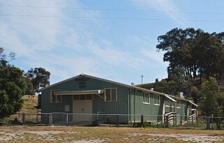
Reedy Dam is a town in the Mallee and Mount Jeffcot wards in the Shire of Buloke, Victoria, Australia. There is a rural CFA station in Reedy Dam. The post office there opened in 1902 and was closed on 31 July 1929. There is a population of approximately 20 people in Reedy Dam (2017).
Wilkur is a locality in the Mount Jeffcot ward of the local government area of the Shire of Buloke and the Warracknabeal ward of the Shire of Yarriambiack, Victoria, Australia. Wilkur post office there opened in 1905, closed on 30 September 1912 reopened on 1 February 1926 and later closed on 27 May 1950. Wilkur South post office opened on 28 June 1920 and was closed on 31 July 1957. Cameron's post office opened on 1 October 1904 renamed Beyal in April 1911 and was closed on 31 August 1929.
Nareewillock is a locality in the Lower Avoca ward of the local government area of the Shire of Buloke, Victoria, Australia.
Maidenwell is a rural town and locality in the South Burnett Region, Queensland, Australia. In the 2016 census, the locality of Maidenwell had a population of 199 people.
Redbanks is a town and locality in South Australia's lower Mid North. The boundaries were formally established in June 1997 for "the long established name".
