
Shepparton is a city located on the floodplain of the Goulburn River in northern Victoria, Australia, approximately 181 kilometres (112 mi) north-northeast of Melbourne. As at June 2018 the estimated population of Shepparton, including the adjacent town of Mooroopna, was 51,631.

Murchison is a small riverside rural village located on the Goulburn River in Victoria, Australia. Murchison is located 167 kilometres from Melbourne and is just to the west of the Goulburn Valley Highway between Shepparton and Nagambie. The surrounding countryside contains orchards, vineyards and dairy farms and also HM Prison Dhurringile. At the 2016 census, Murchison had a population of 925.

Tatura is a town in the Goulburn Valley region of Victoria, Australia, and is situated within the City of Greater Shepparton local government area, 167 kilometres (104 mi) North of the state capital (Melbourne) and 18 kilometres (11 mi) West of the regional centre of Shepparton. At the 2016 census, Tatura had a population of 4,669.
Cobram is a town in the Australian state of Victoria. It is on the Murray River which forms the border between Victoria and New South Wales. Cobram along with the nearby towns of Numurkah and Yarrawonga is part of Shire of Moira and is the administrative centre of the council. Its twin town of Barooga is located on the north side of the Murray River. Surrounding Cobram are a number of orchards, dairy farms and wineries. At the 2016 census, Cobram had a population of 6,014. Barooga's population is currently 1,817.

Arcadia is a small town in Victoria, Australia. It is on Kennedys Road, in the City of Greater Shepparton, south of Shepparton. At the 2016 census, Arcadia had a population of 217.
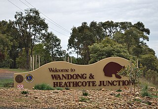
Wandong is a town in Victoria, Australia. The town is about 50 kilometres (30 mi) north of the state capital, Melbourne, on the Hume Highway. It adjoins the town of Heathcote Junction, and at the 2016 census, the two towns had a population of 1,340. The main centre nearest Wandong is Kilmore. Wadong comes from an Aboriginal word meaning "Spirit" or "Ghost".

Undera is a town in the Goulburn Valley region of northern Victoria, Australia. The town in the City of Greater Shepparton local government area, 211 kilometres (131 mi) north of the state capital, Melbourne and 26 kilometres (16 mi) north-west of the regional centre of Shepparton. At the 2011 census, Undera and the surrounding area had a population of 545, declining to just 442 by 2016.

Katamatite is a rural township in Victoria, Australia about 46 kilometres north east of Shepparton. At the 2011 census, Katamatite had a population of 433.

Girgarre is a small town in the Goulburn Valley, Victoria, Australia. It is in the Shire of Campaspe local government area. At the 2016 census, Girgarre and surrounding area had a population of 561.

Toolamba is a town in the Goulburn Valley region of Victoria, Australia. It is in the City of Greater Shepparton local government area, 181 kilometres (112 mi) north of the state capital, Melbourne. At the 2006 census, Toolamba and the surrounding area had a population of 873.

Lancaster is a locality in the Goulburn Valley region of Victoria, Australia. The town is located in Shire of Campaspe and the City of Greater Shepparton. At the 2016 census, Lancaster had a population of 393.

Picola is a town in northern Victoria, Australia. The town is located in the Shire of Moira local government area, 246 kilometres (153 mi) from the state capital, Melbourne. At the 2011 census, Picola had a population of 334.

Longwood is a town in northern Victoria, Australia. The town is located in the Shire of Strathbogie local government area, 149 kilometres (93 mi) from the state capital, Melbourne. At the 2016 census, Longwood and the surrounding area had a population of 240.

The Shire of Cobram was a local government area on the Murray River in the Goulburn Valley region, about 240 kilometres (149 mi) north of Melbourne, the state capital of Victoria, Australia. The shire covered an area of 322 square kilometres (124.3 sq mi), and existed from 1953 until 1994.

The Shire of Rodney was a local government area in the Goulburn Valley region, about 170 kilometres (106 mi) north of Melbourne, the state capital of Victoria, Australia, located between Kyabram and Shepparton. The shire covered an area of 1,009.92 square kilometres (389.9 sq mi), and existed from 1886 until 1994.

Speed is a locality in Victoria, Australia, located approximately 143 km from Mildura, Victoria and about 410 km from Melbourne. Speed was named after William, Harold and Gordon Speed, who settled in the district in 1903. Settlement by the Speed brothers coincided with the opening of the railway line and the opening up of the Mallee lands for farm selection. The Speed township was surveyed in 1910.

Congupna is a town in the Goulburn Valley region of Victoria, Australia. The town is in the City of Greater Shepparton local government area, 203 kilometres (126 mi) north of the state capital, Melbourne and 10 kilometres (6 mi) north of the regional centre of Shepparton. At the 2006 census, Congupna had a population of 616.
Merrigum is a town in the Goulburn Valley region of Victoria, Australia. The town is in the City of Greater Shepparton local government area, 197 kilometres (122 mi) north of the state capital, Melbourne. At the 2011 census, Merrigum had a population of 672.

Kialla is a bounded rural locality of the City of Greater Shepparton local government area in the Goulburn Valley, Victoria, Australia. At the 2016 census, Kialla and surrounding area had a population of approximately 6,800.

Ardmona is a locality in the Goulburn Valley of central Victoria, Australia. It is 10 km west of Shepparton and located in the City of Greater Shepparton local government area. The Midland Highway passes through the south of Ardmona.

