QantasLink is a regional brand of Australian airline Qantas and is an affiliate member of the Oneworld airline alliance. It is a major competitor to Regional Express Airlines and Virgin Australia Regional Airlines. As of September 2010 QantasLink provides 1,900 flights each week to 54 domestic locations.

Frederica Lucy "Rica" Erickson, née Sandilands, was an Australian naturalist, botanical artist, historian, author and teacher. Without any formal scientific training, she wrote extensively on botany and birds, as well as genealogy and general history. Erickson authored ten books, co-authored four, was editor of twelve, and author or co-author of numerous papers and articles that have been printed in popular, scientific and encyclopaedic publications.

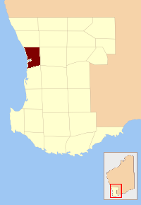
The Shire of Victoria Plains is a local government area in the Wheatbelt region of Western Australia, about 160 kilometres (100 mi) north of the state capital, Perth. It covers an area of 2,569 square kilometres (992 sq mi), and its seat of government is the town of Calingiri.
The County of Perth was one of the 26 counties of Western Australia that were designated in 1829. It contained the city of Perth, with its south-eastern corner near Mount Dale. It was part of the Lands administrative divisions of Western Australia. Today, land titles in the area are associated with the Swan, Canning or Cockburn Sound land districts.

The Shire of Goomalling is a local government area in the Wheatbelt region of Western Australia, about 240 kilometres (149 mi) northeast of Perth, the state capital. The Shire covers an area of 2,836 square kilometres (1,095 sq mi) and its seat of government is the town of Goomalling.
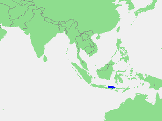
The Bali Sea is the body of water north of the island of Bali and south of Kangean Island in Indonesia. The sea forms the south-west part of the Flores Sea, and the Madura Strait opens into it from the west.

The Shire of Karkarooc was a local government area in northwestern Victoria, Australia. The shire covered an area of 3,719 square kilometres (1,435.9 sq mi), and existed from 1896 until 1995.
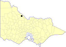
The Borough of Kerang was a local government area in north-western Victoria, Australia. The borough, which for most of its history was part of the surrounding Shire of Kerang, covered an area of 22.60 square kilometres (8.7 sq mi), and existed from 1966 until 1995.

Wilcze Laski is a village in the administrative district of Gmina Szczecinek, within Szczecinek County, West Pomeranian Voivodeship, in north-western Poland. It lies approximately 12 kilometres (7 mi) south of Szczecinek and 143 km (89 mi) east of the regional capital Szczecin.
Kirkby Glacier is a glacier, 20 miles (30 km) in length. This glacier drains the central Anare Mountains of Antarctica and flows northwest to the sea 3 miles (5 km) from Cape North, and just north of Arthurson Bluff, northern Victoria Land.

Durham County was one of the 26 counties of Western Australia that were designated in 1829 as cadastral divisions. It was named after Baron Durham, a British Whig statesman. His father-in-law was Earl Grey. It approximately corresponds to the north-eastern part of the Avon Land District which forms the basis for land titles in the area.
Glenelg County was one of the 26 counties of Western Australia that were designated in 1829 as cadastral divisions. It was named after Charles Grant, 1st Baron Glenelg, President of the Board of Trade and Treasurer of the Navy from September 1827 to June 1828.
Goderich County was one of the 26 counties of Western Australia that were designated in 1829 as cadastral divisions. It was named after F. J. Robinson, 1st Viscount Goderich, Prime Minister of the United Kingdom from August 1827 to January 1828.
Grantham County was one of the 26 counties of Western Australia that were designated in 1829 as cadastral divisions. It approximately corresponds to parts of the Avon Land District and Williams Land District which form the basis for land titles in the area.
Nelson County was one of the 26 counties of Western Australia that were designated in 1829 as cadastral divisions.
Stirling County was one of the 26 counties of Western Australia that were designated in 1829 as cadastral divisions. It approximately corresponds to the southern part of the Hay Land District which forms the basis for land titles in the area.
Wicklow County was one of the 26 counties of Western Australia that were designated in 1829 as cadastral divisions. It was named after William Howard, 4th Earl of Wicklow, a Representative Peer for Ireland.
York County was one of the 26 counties of Western Australia that were designated in 1829 as cadastral divisions. It was named after Prince Frederick, Duke of York and Albany, who was until his death in 1827, the heir presumptive to King George IV. It approximately corresponds to the western part of the Avon Land District which forms the basis for land titles in the area.
The Mackie River is a river in the Wheatbelt region of Western Australia. The river is ephemeral and flows following winter and spring rains. The water discharged is saline.

Beringarra Station, most commonly referred to as Beringarra, is a pastoral lease that once operated as a sheep station but is currently operating as a cattle station in Western Australia.
