Spanțov is a commune in Călărași County, Romania. It is composed of three villages: Cetatea Veche, Spanțov and Stancea.

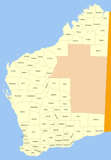
Plantagenet County was one of the 26 counties of Western Australia that were designated in 1829 as cadastral divisions, and was centred on the coastal settlement of Albany. It approximately corresponds to the modern-day Plantagenet Land District which forms the basis for land titles in the area.

Victoria County was one of the twenty six counties of Western Australia that were designated in 1829. It was named after Princess Alexandrina Victoria of Kent, from 1827 second in line to the throne. It approximately corresponds to the north-western section of the Avon Land District which forms the basis for land titles in the area.

Chapman River is a river in the Mid West region of Western Australia.

Manangle Parish, Cumberland is one of the 57 parishes of Cumberland County, New South Wales, a cadastral unit for use on land titles. Its eastern boundary is the Georges River, and western boundary the Nepean River. It includes the southern Sydney suburbs of Menangle Park, Gilead, Rosemeadow and part of Glen Alpine. Major roads in the area include the South Western Freeway, Menangle Road and Appin Road.
Hope River is a river in central Western Australia. It is a tributary of the Yalgar River, which is in turn a tributary of the Murchison River. It rises as an overflow of Lake Anneen about 40 kilometres southwest of Meekatharra, and flows in a northwesterly direction for about 102 kilometres before discharging into the Yalgar.

Rokitnik is a village in the administrative district of Gmina Kiwity, within Lidzbark County, Warmian-Masurian Voivodeship, in northern Poland. It lies approximately 3 kilometres (2 mi) north-east of Kiwity, 14 km (9 mi) east of Lidzbark Warmiński, and 42 km (26 mi) north-east of the regional capital Olsztyn.

Wynki is a village in the administrative district of Gmina Łukta, within Ostróda County, Warmian-Masurian Voivodeship, in northern Poland. It lies approximately 4 kilometres (2 mi) south-east of Łukta, 14 km (9 mi) north-east of Ostróda, and 26 km (16 mi) west of the regional capital Olsztyn.

Jarzysław is a village in the administrative district of Gmina Płoty, within Gryfice County, West Pomeranian Voivodeship, in north-western Poland. It lies a few kilometres south-east of Płoty.
Kastja is a village in Lääne-Nigula Parish, Lääne County, in western Estonia.

Grey County was one of the 26 counties of Western Australia that were designated in 1829 as cadastral divisions. It was named after Charles Grey, 2nd Earl Grey, a powerful opposition Whig MP, who was to become Prime Minister of the United Kingdom of Great Britain and Ireland from 1830-1834. It approximately corresponds to the southern part of the Ninghan Land District which forms the basis for land titles in the area.

Hay County was one of the 26 counties of Western Australia that were designated in 1829 as cadastral divisions. It approximately corresponds to the southeastern Kojonup Land District and northern Plantagenet Land District which form the basis for land titles in the area.

Howick County was one of the 26 counties of Western Australia that were designated in 1829 as cadastral divisions. It was named after Viscount Howick, a well-connected Whig MP who was to become Under-Secretary of State for War and the Colonies in 1830. It approximately corresponds to the southeastern part of the Avon Land District which forms the basis for land titles in the area.

Minto County was one of the 26 counties of Western Australia that were designated in 1829 as cadastral divisions. It approximately corresponds to parts of the Avon Land District and Williams Land District which form the basis for land titles in the area.

Peel County was one of the 26 counties of Western Australia that were designated in 1829 as cadastral divisions. It was named after Sir Robert Peel, Home Secretary from 1822–1827 and 1828–1830.

Twiss County was one of the 26 counties of Western Australia that were designated in 1829 as cadastral divisions. It was named after Horace Twiss, Under-Secretary of State for War and the Colonies from 1828–1830, a personal friend of Lieutenant-Governor James Stirling.
Hämmelepa is a village in Saaremaa Parish, Saare County in western Estonia.
Rahniku is a village in Saaremaa Parish, Saare County in western Estonia.

Nookawarra Land District is a land district of Western Australia, located within the North-West Land Division.

The County of Lytton is a county in the Darling Downs region of Queensland, Australia. It was named and bounded by the Governor in Council on 7 March 1901 under the Land Act 1897.


