Sepia irvingi is a species of cuttlefish native to the southeastern Indian Ocean, specifically western Australia, from Cockburn Sound to North West Shelf. It lives at a depth of between 130 and 170 m.
The County of Perth was one of the 26 counties of Western Australia that were designated in 1829. It contained the city of Perth, with its south-eastern corner near Mount Dale. It was part of the Lands administrative divisions of Western Australia. Today, land titles in the area are associated with the Swan, Canning or Cockburn Sound land districts.

Plantagenet County was one of the 26 counties of Western Australia that were designated in 1829 as cadastral divisions, and was centred on the coastal settlement of Albany. It approximately corresponds to the modern-day Plantagenet Land District which forms the basis for land titles in the area.

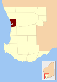
Victoria County was one of the twenty six counties of Western Australia that were designated in 1829. It was named after Princess Alexandrina Victoria of Kent, from 1827 second in line to the throne. It approximately corresponds to the north-western section of the Avon Land District which forms the basis for land titles in the area.
Będzelin is a village in the administrative district of Gmina Koluszki, within Łódź East County, Łódź Voivodeship, in central Poland. It lies approximately 4 kilometres (2 mi) south of Koluszki and 26 km (16 mi) east of the regional capital Łódź. The population of the village is approximately 430 people.

Węgliny is a village in the administrative district of Gmina Gubin, within Krosno Odrzańskie County, Lubusz Voivodeship, in western Poland, close to the German border. It lies approximately 15 kilometres (9 mi) south of Gubin, 36 km (22 mi) south-west of Krosno Odrzańskie, and 56 km (35 mi) west of Zielona Góra.
Przynotecko is a village in the administrative district of Gmina Stare Kurowo, within Strzelce-Drezdenko County, Lubusz Voivodeship, in western Poland. It lies approximately 6 kilometres (4 mi) south-east of Stare Kurowo, 15 km (9 mi) south-east of Strzelce Krajeńskie, and 33 km (21 mi) east of Gorzów Wielkopolski.
Kõnnu is a village in Põhja-Pärnumaa Parish, Pärnu County in western-central Estonia.

Glenelg County was one of the 26 counties of Western Australia that were designated in 1829 as cadastral divisions. It was named after Charles Grant, 1st Baron Glenelg, President of the Board of Trade and Treasurer of the Navy from September 1827 to June 1828.
Goderich County was one of the 26 counties of Western Australia that were designated in 1829 as cadastral divisions. It was named after F. J. Robinson, 1st Viscount Goderich, Prime Minister of the United Kingdom from August 1827 to January 1828.
Grantham County was one of the 26 counties of Western Australia that were designated in 1829 as cadastral divisions. It approximately corresponds to parts of the Avon Land District and Williams Land District which form the basis for land titles in the area.
Grey County was one of the 26 counties of Western Australia that were designated in 1829 as cadastral divisions. It was named after Charles Grey, 2nd Earl Grey, a powerful opposition Whig MP, who was to become Prime Minister of the United Kingdom of Great Britain and Ireland from 1830-1834. It approximately corresponds to the southern part of the Ninghan Land District which forms the basis for land titles in the area.
Lanark County was one of the 26 counties of Western Australia that were designated in 1829 as cadastral divisions. It was named after the County of Lanark, Scotland, birthplace of Lieutenant-Governor James Stirling.
Melbourne County was one of the 26 counties of Western Australia that were designated in 1829 as cadastral divisions. It was named after William Lamb, 2nd Viscount Melbourne, Chief Secretary for Ireland by Lieutenant-Governor James Stirling.
Murray County was one of the 26 counties of Western Australia that were designated in 1829 as cadastral divisions. It was named after George Murray, Secretary of State for War and the Colonies from 1828–1830, a personal friend of Lieutenant-Governor James Stirling.
Stirling County was one of the 26 counties of Western Australia that were designated in 1829 as cadastral divisions. It approximately corresponds to the southern part of the Hay Land District which forms the basis for land titles in the area.
Wellington County was one of the 26 counties of Western Australia that were designated in 1829 as cadastral divisions. It was named after Arthur Wellesley, 1st Duke of Wellington, Commander-in-Chief of the British Army from 1827-1828. It approximately corresponds to the Wellington Land District which forms the basis for land titles in the area.
Wicklow County was one of the 26 counties of Western Australia that were designated in 1829 as cadastral divisions. It was named after William Howard, 4th Earl of Wicklow, a Representative Peer for Ireland.
Mount Hardy is a mountain standing close east of Mount Oldfield in the northwest part of the Tula Mountains, in Enderby Land, Antarctica. It was plotted from air photos taken from Australian National Antarctic Research Expeditions aircraft in 1956 and was named by the Antarctic Names Committee of Australia for K. Hardy, a weather observer at Wilkes Station in 1959.
The Mackie River is a river in the Wheatbelt region of Western Australia. The river is ephemeral and flows following winter and spring rains. The water discharged is saline.


