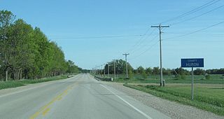
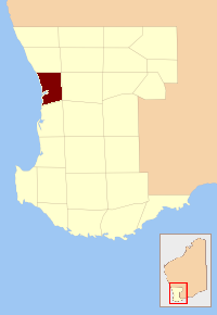
Huron County is a county of the province of Ontario, Canada. It is located on the southeast shore of its namesake, Lake Huron, in the southwest part of the province. The county seat is Goderich, also the county's largest community.

Goderich is a town in the Canadian province of Ontario and is the county seat of Huron County. The town was founded by John Galt and William "Tiger" Dunlop of the Canada Company in 1827. First laid out in 1828, the town is named after Frederick John Robinson, 1st Viscount Goderich, who was prime minister of the United Kingdom at the time. It was incorporated as a town in 1850.

Murang'a is a town in Murang'a County of Kenya. Before the independence of Kenya in 1963, this town used to be called Fort Hall. It is the administrative centre of Murang'a County and is mainly inhabited by the Kikuyu community. According to the 2019 census, the town has a population of about 110,000.
Mount Elgon District was an administrative district in the Western Province of Kenya. Its capital town was Kapsokwony. In 2010, it was merged into Bungoma County.
The County of Perth was one of the 26 counties of Western Australia that were designated in 1829. It contained the city of Perth, with its south-eastern corner near Mount Dale. It was part of the Lands administrative divisions of Western Australia. Today, land titles in the area are associated with the Swan, Canning or Cockburn Sound land districts.

Victoria County was one of the twenty six counties of Western Australia that were designated in 1829. It was named after Princess Alexandrina Victoria of Kent, from 1827 second in line to the throne. It approximately corresponds to the north-western section of the Avon Land District which forms the basis for land titles in the area.
The lands administrative divisions of Western Australia refer to subdivisions of the state of Western Australia for cadastral purposes, most of which have been in place since the 19th century. The state is divided up for this purpose into five land divisions, which in turn are subdivided into land districts, which correspond to counties in other Australian states. These districts are then subdivided further into numbered locations, as well as gazetted townsites. Together, they form part of the lands administrative divisions of Australia.

Manilla River, a perennial stream that is part of the Namoi catchment within the Murray–Darling basin, is located in the Northern Tablelands district of New South Wales, Australia.
The Kent River is a river in the Great Southern of Western Australia.

Nelson Land District is a land district of Western Australia, located within the South West Division on the state's south coast. It covers part of the state's Lower South West region and includes the townsites of Bridgetown, Manjimup, Pemberton, Northcliffe and Nannup as well as Point D'Entrecasteaux and, at its far southeastern corner, Walpole.

Glenelg County was one of the 26 counties of Western Australia that were designated in 1829 as cadastral divisions. It was named after Charles Grant, 1st Baron Glenelg, President of the Board of Trade and Treasurer of the Navy from September 1827 to June 1828.
Grantham County was one of the 26 counties of Western Australia that were designated in 1829 as cadastral divisions. It approximately corresponds to parts of the Avon Land District and Williams Land District which form the basis for land titles in the area.
Lanark County was one of the 26 counties of Western Australia that were designated in 1829 as cadastral divisions. It was named after the County of Lanark, Scotland, birthplace of Lieutenant-Governor James Stirling.
Murray County was one of the 26 counties of Western Australia that were designated in 1829 as cadastral divisions. It was named after George Murray, Secretary of State for War and the Colonies from 1828 to 1830, a personal friend of Lieutenant-Governor James Stirling.
Nelson County was one of the 26 counties of Western Australia that were designated in 1829 as cadastral divisions.
Stirling County was one of the 26 counties of Western Australia that were designated in 1829 as cadastral divisions. It approximately corresponds to the southern part of the Hay Land District which forms the basis for land titles in the area.
Wellington County was one of the 26 counties of Western Australia that were designated in 1829 as cadastral divisions. It was named after Arthur Wellesley, 1st Duke of Wellington, Prime Minister of the United Kingdom from 1828-1830. It approximately corresponds to the Wellington Land District which forms the basis for land titles in the area.
Wicklow County was one of the 26 counties of Western Australia that were designated in 1829 as cadastral divisions. It was named after William Howard, 4th Earl of Wicklow, a Representative Peer for Ireland.
York County was one of the 26 counties of Western Australia that were designated in 1829 as cadastral divisions. It was named after Prince Frederick, Duke of York and Albany, who was until his death in 1827, the heir presumptive to King George IV. It approximately corresponds to the western part of the Avon Land District which forms the basis for land titles in the area.
Goombi is a rural locality in the Western Downs Region, Queensland, Australia. In the 2016 census, Goombi had a population of 34 people.
