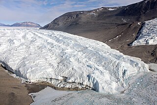
The Taylor Glacier is a glacier in Antarctica about 35 nautical miles long, flowing from the plateau of Victoria Land into the western end of Taylor Valley, north of the Kukri Hills. It flows to the south of the Asgard Range. The middle part of the glacier is bounded on the north by the Inland Forts and on the south by Beacon Valley.
The Stirling Range or Koikyennuruff is a range of mountains and hills in the Great Southern region of Western Australia, 337 kilometres (209 mi) south-east of Perth. It is over 60 kilometres (37 mi) wide from west to east, stretching from the highway between Mount Barker and Cranbrook eastward past Gnowangerup. The Stirling Range is protected by the Stirling Range National Park, which was gazetted in 1913, and has an area of 1,159 km2 (447 sq mi).
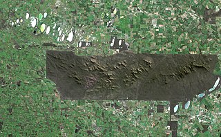
County Peak, also known as Mt Quajabin or Quajabin Peak, is located in the western zone of the Wheatbelt region of Western Australia, about 120 km south-east of Perth.

Plantagenet County was one of the 26 counties of Western Australia that were designated in 1829 as cadastral divisions, and was centred on the coastal settlement of Albany. It approximately corresponds to the modern-day Plantagenet Land District which forms the basis for land titles in the area.
The lands administrative divisions of Western Australia refer to subdivisions of the state of Western Australia for cadastral purposes, most of which have been in place since the 19th century. The state is divided up for this purpose into five land divisions, which in turn are subdivided into land districts, which correspond to counties in other Australian states. These districts are then subdivided further into numbered locations, as well as gazetted townsites. Together, they form part of the lands administrative divisions of Australia.

The Collie River is a river in the South West region of Western Australia.
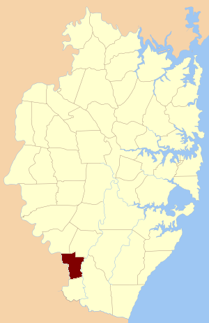
Manangle Parish, Cumberland is one of the 57 parishes of Cumberland County, New South Wales, a cadastral unit for use on land titles. Its eastern boundary is the Georges River, and western boundary the Nepean River. It includes the southern Sydney suburbs of Menangle Park, Gilead, Rosemeadow and part of Glen Alpine. Major roads in the area include the South Western Freeway, Menangle Road and Appin Road.
Yule Bay is a bay indenting the coast of northern Victoria Land between Cape Hooker and Cape Dayman. An inner (western) portion of the bay is circumscribed by Bates Point and Ackroyd Point.
Hope River is a river in central Western Australia. It is a tributary of the Yalgar River, which is in turn a tributary of the Murchison River. It rises as an overflow of Lake Anneen about 40 kilometres southwest of Meekatharra, and flows in a northwesterly direction for about 102 kilometres before discharging into the Yalgar.

Durham County was one of the 26 counties of Western Australia that were designated in 1829 as cadastral divisions. It was named after Baron Durham, a British Whig statesman. His father-in-law was Earl Grey. It approximately corresponds to the north-eastern part of the Avon Land District which forms the basis for land titles in the area.
Grey County was one of the 26 counties of Western Australia that were designated in 1829 as cadastral divisions. It was named after Charles Grey, 2nd Earl Grey, a powerful opposition Whig MP, who was to become Prime Minister of the United Kingdom of Great Britain and Ireland from 1830-1834. It approximately corresponds to the southern part of the Ninghan Land District which forms the basis for land titles in the area.
Hay County was one of the 26 counties of Western Australia that were designated in 1829 as cadastral divisions. It was named after Robert William Hay, Under-Secretary of State for the Colonies from 1825 to 1836. It approximately corresponds to the southeastern Kojonup Land District and northern Plantagenet Land District which form the basis for land titles in the area.
Minto County was one of the 26 counties of Western Australia that were designated in 1829 as cadastral divisions. It approximately corresponds to parts of the Avon Land District and Williams Land District which form the basis for land titles in the area.
Nelson County was one of the 26 counties of Western Australia that were designated in 1829 as cadastral divisions.
Peel County was one of the 26 counties of Western Australia that were designated in 1829 as cadastral divisions. It was named after Sir Robert Peel, Home Secretary from 1822–1827, and Home Secretary and Leader of the House of Commons from 1828–1830.
Stirling County was one of the 26 counties of Western Australia that were designated in 1829 as cadastral divisions. It approximately corresponds to the southern part of the Hay Land District which forms the basis for land titles in the area.

Kukri Hills is a prominent east-west trending range, about 25 nautical miles (46 km) long and over 2,000 metres (6,600 ft) high, forming the divide between Ferrar Glacier on the south and Taylor Glacier and Taylor Valley on the north, in Victoria Land, Antarctica. They are south of the Asgard Range, east of the Quartermain Mountains and north of the Royal Society Range.
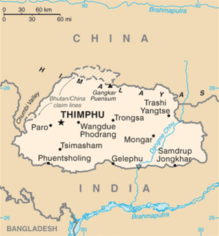
This is a list of the extreme points of Bhutan.
