
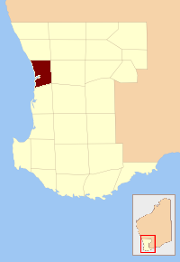
Nelson County was one of the 26 counties of Western Australia that were designated in 1829 as cadastral divisions. [1]
It approximately corresponds to the northern part of the Nelson Land District which forms the basis for land titles in the area.
Nelson County was one of the 26 counties of Western Australia that were designated in 1829 as cadastral divisions. [1]
It approximately corresponds to the northern part of the Nelson Land District which forms the basis for land titles in the area.
This is a list of the extreme points of The Americas, the points that are farther north, south, east or west than any other location on the continent. The continent's southernmost point is often said to be Cape Horn, which is the southernmost point of the Chilean islands. The Americas cross 134° of longitude east to west and 124° of latitude north to south.
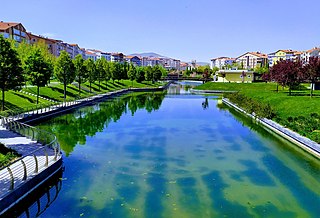
Kırşehir Province is a province in central Turkey, forming part of the Central Anatolia Region. Its area is 6,584 km2, and its population is 244,519 (2022). It stands on the North Anatolian Fault, and is currently in an earthquake warning zone. The average elevation is approximately 985 meters above sea level. The provincial capital is Kırşehir. The geographical centre of all land surfaces on Earth is at 39°00′N34°00′E, in Kırşehir Province, Turkey.

Mac. Robertson Land is the portion of Antarctica lying southward of the coast between William Scoresby Bay and Cape Darnley. It is located at 70°00′S65°00′E. In the east, Mac. Robertson Land includes the Prince Charles Mountains. It was named by the British Australian and New Zealand Antarctic Research Expedition (BANZARE) (1929–1931), under Sir Douglas Mawson, after Sir Macpherson Robertson of Melbourne, a patron of the expedition.
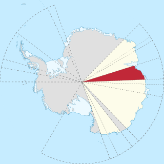
Princess Elizabeth Land is the sector of Antarctica between longitude 73° east and Cape Penck. The sector is claimed by Australia as part of the Australian Antarctic Territory, although this claim is not widely recognised.
The County of Perth was one of the 26 counties of Western Australia that were designated in 1829. It contained the city of Perth, with its south-eastern corner near Mount Dale. It was part of the Lands administrative divisions of Western Australia. Today, land titles in the area are associated with the Swan, Canning or Cockburn Sound land districts.

The County of Croajingolong is one of the 37 counties of Victoria which are part of the cadastral divisions of Australia, used for land titles. It is the most easterly county, and includes the Croajingolong National Park. Its western boundary is the Snowy River. The county was proclaimed in 1871 together with others from the Gipps Land District. Some time earlier maps showed proposed counties of Howe and Combermere occupying the area of Croajingolong.
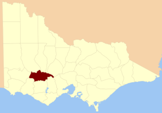
The County of Ripon is one of the 37 counties of Victoria which are part of the cadastral divisions of Australia, used for land titles. The county includes the plains of the Western District from Ballarat in the east to the Grampians in the west. Larger towns include Beaufort. The county was proclaimed in 1849.
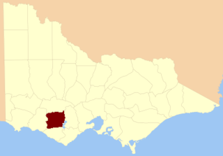
The County of Hampden is one of the 37 counties of Victoria which are part of the cadastral divisions of Australia, used for land titles. The county is in the Western District of Victoria bounded by Lake Corangamite in the east and the Hopkins River in the west. In the north and south the county was bounded approximately by the existing roads, now the Glenelg Highway and the Princes Highway. Larger towns include Terang and Skipton. The county was proclaimed in 1849.
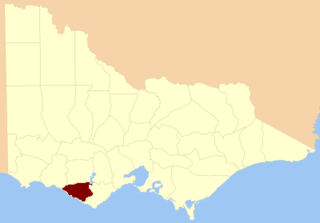
The County of Heytesbury is one of the 37 counties of Victoria which are part of the cadastral divisions of Australia, used for land titles. The county is in the Western District of Victoria bounded by the Gellibrand River in the east and the Hopkins River in the west. In the north, the county was bounded approximately by the existing road, now the Princes Highway. Larger towns include Camperdown and Cobden. The county was proclaimed in 1849.

The County of Dundas is one of the 37 counties of Victoria which are part of the cadastral divisions of Australia, used for land titles. The county is in the Western District of Victoria bounded by the Glenelg River in the west and north, by a line from Casterton to Penshurst in the south, and by the eastern edge of the Grampians in the east. Larger towns include Hamilton, Casterton and Coleraine. The county was proclaimed in 1849.

Nelson Land District is a land district of Western Australia, located within the South West Division on the state's south coast. It covers part of the state's Lower South West region and includes the townsites of Bridgetown, Manjimup, Pemberton, Northcliffe and Nannup as well as Point D'Entrecasteaux and, at its far southeastern corner, Walpole.

Aotaka was the second vessel in the Hatsutaka class of medium-sized minelayers of the Imperial Japanese Navy, which was in service during World War II. She was designed as an improved version of the netlayer Shirataka. However, during the Pacific War, due to the critical shortage of patrol ships for convoy escort duties, she was fitted with depth charge racks and her minelaying rails were removed.

Lanark County was one of the 26 counties of Western Australia that were designated in 1829 as cadastral divisions. It was named after the County of Lanark, Scotland, birthplace of Lieutenant-Governor James Stirling.
Murray County was one of the 26 counties of Western Australia that were designated in 1829 as cadastral divisions. It was named after George Murray, Secretary of State for War and the Colonies from 1828 to 1830, a personal friend of Lieutenant-Governor James Stirling.
Sussex County was one of the 26 counties of Western Australia that were designated in 1829 as cadastral divisions. Lieutenant-Governor James Stirling named the county in honour of Prince Augustus Frederick, Duke of Sussex, the sixth son of George III.
Wellington County was one of the 26 counties of Western Australia that were designated in 1829 as cadastral divisions. It was named after Arthur Wellesley, 1st Duke of Wellington, Prime Minister of the United Kingdom from 1828-1830. It approximately corresponds to the Wellington Land District which forms the basis for land titles in the area.

Cooperation Sea, also called Commonwealth Sea (erratum) or Sodruzhestvo Sea, is a proposed sea name for part of the Southern Ocean, between Enderby Land and West Ice Shelf (85°E), off the coast of MacRobertson Land and Princess Elizabeth Land. It would stretch over an area of 258,000 km2. It would be bordered by the Davis Sea on the east, and by another Russian proposal to the 2002 International Hydrographic Organization (IHO) draft, a Cosmonauts Sea to the west.

Sinop Province is a province of Turkey, along the Black Sea. It is located between 41 and 42 degrees North latitude and between 34 and 35 degrees East longitude. Its area is 5,717 km2, equivalent to 0.73% of Turkey's total area, and its population is 220,799 (2022).. The borders total 475 km and consists of 300 km of land and 175 km seaside borders. Its adjacent provinces are Kastamonu on the west, Çorum on the south, and Samsun on the southeast.