Ross Township is a township in Luzerne County, Pennsylvania, United States. The population was 2,937 at the 2010 census.

The Java Sea is an extensive shallow sea on the Sunda Shelf. It lies between the Indonesian islands of Borneo to the north, Java to the south, Sumatra to the west, and Sulawesi to the east. Karimata Strait to its northwest links it to the South China Sea. It is a part of the western Pacific Ocean.

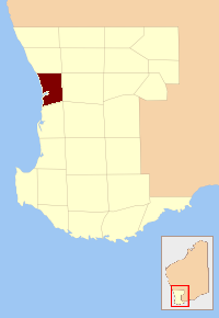
The City of Gosnells is a local government area in the southeastern suburbs of the Western Australian capital city of Perth, located northwest of Armadale and about 20 kilometres (12 mi) southeast of Perth's central business district. The City covers an area of 128 square kilometres (49.42 sq mi), much of which is state forest rising into the Darling Scarp to the east, and had a population of approximately 118,000 at the 2016 Census. The largest activity centre in the City is the Central Maddington shopping centre. District centres exist in the Gosnells town centre, Thornlie and Canning Vale.
Greater Perth is Perth's Greater Capital City Statistical Area (GCCSA), a geographical area designed to represent the functional extent of Western Australia's (WA) capital city.
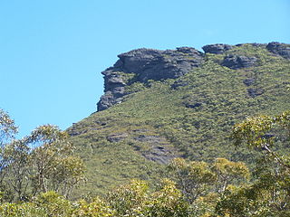
Granite outcrops of Western Australia are weathered landforms that occur throughout the state of Western Australia, composed primarily of the rock type granite. All recognised types of this landform can be observed, commonly as bornhardts, but also as inselbergs, castle koppies and Nubbins. Rising abruptly from the surrounding landscape they create a variety of microhabitats for plants, and provide seasonal resources and refuge for a range of animals. These areas thus have rich biodiversity and many endemic species. They are significant locations that tie in with the Aboriginal and European cultural heritage of Western Australia.

The Shire of Westonia is a local government area in the eastern Wheatbelt region of Western Australia, about 310 kilometres (193 mi) east of Perth, the state capital. Its seat of government is the small town of Westonia.
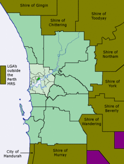
The Metropolitan Region Scheme (MRS) provides the legal basis for future land use planning throughout the Perth metropolitan region. It classifies land into broad zones and reservations and is administered by the Western Australian Planning Commission. It is one of three regional schemes in Western Australia. The MRS is updated via an ongoing process of amendments. Amendments to the MRS are typically informed by a series of strategic plans prepared by the Department of Planning, Lands and Heritage. Detailed land use planning within the area of the MRS is undertaken by local governments and other statutory authorities which prepare one or more local planning schemes within their administrative boundaries. Local plannings schemes must be consistent with the MRS and require the approval of the WAPC. The acquisition of land reserved under the MRS is funded by a hypothecated land tax called the Metropolitan Region Improvement Tax.
The County of Perth was one of the 26 counties of Western Australia that were designated in 1829. It contained the city of Perth, with its south-eastern corner near Mount Dale. It was part of the Lands administrative divisions of Western Australia. Today, land titles in the area are associated with the Swan, Canning or Cockburn Sound land districts.

The Shire of Meekatharra is a local government area in the Mid West region of Western Australia, about halfway between the town of Port Hedland and the state capital, Perth, Western Australia. The Shire covers an area of 100,789 square kilometres (38,915 sq mi), and its seat of government is the town of Meekatharra.
Kalgan is a small town in the Great Southern region of Western Australia.
The Yule River is an ephemeral river in the Pilbara region of Western Australia. It was named on 10 August 1861 by the surveyor and explorer Frank Gregory while on expedition in the area, after Thomas Newte Yule, at times farmer of Toodyay, winemaker, Acting Colonial Secretary and Magistrate.

Beaufort County was one of the 26 counties of Western Australia that were designated in 1829 as cadastral divisions. It approximately corresponds to the far eastern end of the Avon Land District which forms the basis for land titles in the area.
Kent County was one of the 26 counties of Western Australia that were designated in 1829. It was named after Princess Alexandrina Victoria of Kent, from 1827 second in line to the throne.
Lansdowne County was one of the 26 counties of Western Australia that were designated in 1829 as cadastral divisions. It was named after Henry Petty-Fitzmaurice, 3rd Marquess of Lansdowne, Secretary of State for the Home Department from 1827-1828. It approximately corresponds to the Jilbadji Land District which was gazetted in 1903 and forms the basis for land titles in the area.
Twiss County was one of the 26 counties of Western Australia that were designated in 1829 as cadastral divisions. It was named after Horace Twiss, Under-Secretary of State for War and the Colonies from 1828–1830, a personal friend of Lieutenant-Governor James Stirling.

Kyarra Land District is a land district of Western Australia, located within the North-West Land Division.

Annean Station is a pastoral lease in Western Australia.
Cogla Downs Station is a pastoral lease and sheep station located in the Mid West region of Western Australia.
Belele Station is a pastoral lease in Western Australia that operates as a cattle station and as a sheep station for the production of wool.
Mount Vernon Station is a pastoral lease that operates as a cattle station.
