
Ellis County is a county located in the U.S. state of Kansas. As of the 2020 census, the county population was 28,934. Its county seat and most populous city is Hays.

The Java Sea is an extensive shallow sea on the Sunda Shelf, between the Indonesian islands of Borneo to the north, Java to the south, Sumatra to the west, and Sulawesi to the east. Karimata Strait to its northwest links it to the South China Sea. It is a part of the western Pacific Ocean.

Hay is a town in the western Riverina region of south western New South Wales, Australia. It is the administrative centre of Hay Shire local government area and the centre of a prosperous and productive agricultural district on the wide Hay Plains.

The St George region of Sydney is part of the southern suburbs of Sydney, in the state of New South Wales, Australia. The area includes all the suburbs in the local government area of Georges River Council and the part of Bayside Council which was Rockdale City prior to 2016. The eastern boundary of the district is Lady Robinson Beach on Botany Bay. The name "St George" derives from the cadastral Parish of St George, and the area was later covered by the St George County Council, the electricity supplier for the councils in this region. While generally being considered part of Southern Sydney the area is occasionally included as part of the Inner South-West.
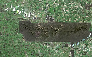
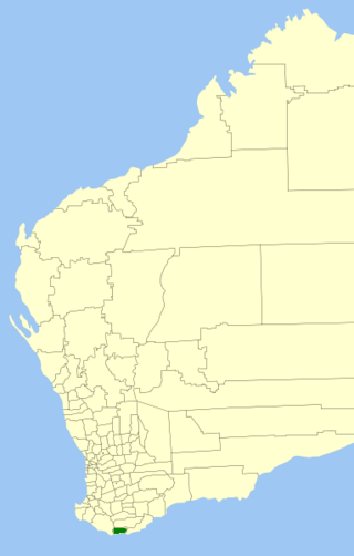
The Stirling Range or Koikyennuruff is a range of mountains and hills in the Great Southern region of Western Australia, 337 kilometres (209 mi) south-east of Perth. It is over 60 kilometres (37 mi) wide from west to east, stretching from the highway between Mount Barker and Cranbrook eastward past Gnowangerup. The Stirling Range is protected by the Stirling Range National Park, which was gazetted in 1913, and has an area of 1,159 km2 (447 sq mi).

Alaca is one of the largest districts of Çorum Province in the Black Sea region of Turkey. It is located 52 km (32 mi) from the city of Çorum, on a road from the Black Sea coast to central Anatolia. Population is 22,092 as of 2010.

Plantagenet County was one of the 26 counties of Western Australia that were designated in 1829 as cadastral divisions, and was centred on the coastal settlement of Albany. It approximately corresponds to the modern-day Plantagenet Land District which forms the basis for land titles in the area.
The lands administrative divisions of Western Australia refer to subdivisions of the state of Western Australia for cadastral purposes, most of which have been in place since the 19th century. The state is divided up for this purpose into five land divisions, which in turn are subdivided into land districts, which correspond to counties in other Australian states. These districts are then subdivided further into numbered locations, as well as gazetted townsites. Together, they form part of the lands administrative divisions of Australia.
The Shire of Denmark is a local government area in the Great Southern region of Western Australia, about 55 kilometres (34 mi) west of Albany and about 420 kilometres (261 mi) south-southeast of the state capital, Perth. The Shire of Denmark covers an area of 1,860 square kilometres (718 sq mi), and its seat of government is located in the townsite and locality of Denmark.

The Hay River is a river in the Great Southern region of Western Australia. The traditional owners of the area are the Noongar people, who know the river as Genulup.

The Denmark River is located in the Great Southern region of Western Australia. The river rises near Pardelup and meanders in a southerly direction until it flows through Denmark into Wilson Inlet. The traditional owners of the area are the Noongar people, who know the river as Kwoorabup, meaning the place of the Western brush wallaby.

Durham County was one of the 26 counties of Western Australia that were designated in 1829 as cadastral divisions. It was named after Baron Durham, a British Whig statesman. His father-in-law was Earl Grey. It approximately corresponds to the north-eastern part of the Avon Land District which forms the basis for land titles in the area.
Goderich County was one of the 26 counties of Western Australia that were designated in 1829 as cadastral divisions. It was named after F. J. Robinson, 1st Viscount Goderich, Prime Minister of the United Kingdom from August 1827 to January 1828.
Grey County was one of the 26 counties of Western Australia that were designated in 1829 as cadastral divisions. It was named after Charles Grey, 2nd Earl Grey, a powerful opposition Whig MP, who was to become Prime Minister of the United Kingdom of Great Britain and Ireland from 1830-1834. It approximately corresponds to the southern part of the Ninghan Land District which forms the basis for land titles in the area.
Howick County was one of the 26 counties of Western Australia that were designated in 1829 as cadastral divisions. It was named after Viscount Howick, a well-connected Whig MP who was to become Under-Secretary of State for War and the Colonies in 1830. It approximately corresponds to the southeastern part of the Avon Land District which forms the basis for land titles in the area.
Minto County was one of the 26 counties of Western Australia that were designated in 1829 as cadastral divisions. It approximately corresponds to parts of the Avon Land District and Williams Land District which form the basis for land titles in the area.
Nelson County was one of the 26 counties of Western Australia that were designated in 1829 as cadastral divisions.
Peel County was one of the 26 counties of Western Australia that were designated in 1829 as cadastral divisions. It was named after Sir Robert Peel, Home Secretary from 1822–1827, and Home Secretary and Leader of the House of Commons from 1828–1830.
Stirling County was one of the 26 counties of Western Australia that were designated in 1829 as cadastral divisions. It approximately corresponds to the southern part of the Hay Land District which forms the basis for land titles in the area.
Pyramid Station is a pastoral lease and cattle station located approximately 100 kilometres (62 mi) east of Karratha in the Pilbara region of Western Australia. The station has also previously run sheep on its pastures.
