This article does not cite any sources . (March 2011) (Learn how and when to remove this template message) |
Yilgarn Western Australia | |
---|---|
Yilgarn Land District is a land district (cadastral division) of Western Australia, located within the Eastern Land Division.
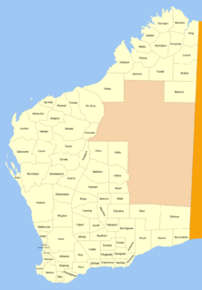
The lands administrative divisions of Western Australia refer to subdivisions of the state of Western Australia for cadastral purposes, most of which have been in place since the 19th century. The state is divided up for this purpose into five land divisions, which in turn are subdivided into land districts, which correspond to counties in other Australian states. These districts are then subdivided further into numbered locations, as well as gazetted townsites. Together, they form part of the lands administrative divisions of Australia.
Western Australia is a state occupying the entire western third of Australia. It is bounded by the Indian Ocean to the north and west, and the Southern Ocean to the south, the Northern Territory to the north-east, and South Australia to the south-east. Western Australia is Australia's largest state, with a total land area of 2,529,875 square kilometres, and the second-largest country subdivision in the world, surpassed only by Russia's Sakha Republic. The state has about 2.6 million inhabitants – around 11 percent of the national total – of whom the vast majority live in the south-west corner, 79 per cent of the population living in the Perth area, leaving the remainder of the state sparsely populated.
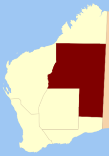
Eastern Division is one of five land divisions of Western Australia, part of the cadastral divisions of Western Australia. Most of the land is desert, part of the Great Sandy Desert, Gibson Desert and Great Victoria Desert. It is located in the eastern parts of the Goldfields-Esperance region and the Pilbara region.
Coordinates: 30°50′S119°05′E / 30.833°S 119.083°E
A geographic coordinate system is a coordinate system that enables every location on Earth to be specified by a set of numbers, letters or symbols. The coordinates are often chosen such that one of the numbers represents a vertical position and two or three of the numbers represent a horizontal position; alternatively, a geographic position may be expressed in a combined three-dimensional Cartesian vector. A common choice of coordinates is latitude, longitude and elevation. To specify a location on a plane requires a map projection.
This article about a location in Western Australia is a stub. You can help Wikipedia by expanding it. |
The geography of France consists of a terrain that is mostly flat plains or gently rolling hills in the north and west and mountainous in the south and the east. Metropolitan France has a total size of 551,695 km2 (213,011 sq mi). It is the third largest country in Europe after Russia and the Ukraine.
The Arctic Archipelago, also known as the Canadian Arctic Archipelago, groups together all islands lying to the north of the Canadian continental mainland excluding Greenland.
Borchgrevink Glacier is a large glacier in the Victory Mountains, Victoria Land, draining south between Malta Plateau and Daniell Peninsula, and thence projecting into Glacier Strait, Ross Sea, as a floating glacier tongue, the Borchgrevink Glacier Tongue, just south of Cape Jones. It was named by the New Zealand Geological Survey Antarctic Expedition, 1957–58, for Carsten Borchgrevink, leader of the British Antarctic Expedition, 1898–1900. Borchgrevink visited the area in February 1900 and first observed the seaward portion of the glacier.
Bạch Thông is a rural district of Bắc Kạn Province in the Northeast region of Vietnam. As of 2003 the district had a population of 31,585. The district covers an area of 546 km². The district capital lies at Phủ Thông.
Krông Buk, formerly Buon Ho) is a district (huyện) of Đắk Lắk Province in the Central Highlands region of Vietnam. It was established as a district of the Socialist Republic of Vietnam in 1976 during the reunification of Vietnam.
Ân Thi is a rural district of Hưng Yên Province in the Red River Delta region of Vietnam. As of 2003 the district had a population of 135,423. The district covers an area of 128 km². The district capital lies at Ân Thi.
An Biên is a rural district of Kiên Giang Province in the Mekong Delta region of Vietnam. As of 2003 the district had a population of 147,297. The district covers an area of 466 km². The district capital lies at Thứ Ba.
Dziembowo is a village in the administrative district of Gmina Kaczory, within Piła County, Greater Poland Voivodeship, in west-central Poland. It lies approximately 4 kilometres (2 mi) south-west of Kaczory, 10 km (6 mi) south-east of Piła, and 77 km (48 mi) north of the regional capital Poznań.
Stary Cieszyn is a village in the administrative district of Gmina Godkowo, within Elbląg County, Warmian-Masurian Voivodeship, in northern Poland. It lies approximately 29 kilometres (18 mi) east of Elbląg and 55 km (34 mi) north-west of the regional capital Olsztyn.
Przydarłów is a village in the administrative district of Gmina Kozielice, within Pyrzyce County, West Pomeranian Voivodeship, in north-western Poland. It lies approximately 7 kilometres (4 mi) south-west of Pyrzyce and 41 km (25 mi) south-east of the regional capital Szczecin.
Baghdati is a district of Georgia, in the region of Imereti. Its main town is Baghdati.
Velký Chlumec is a village and municipality in Beroun District in the Central Bohemian Region of the Czech Republic.
Al Haymah Al Kharijiyah District is a district of the Sana'a Governorate, Yemen. As of 2003, the district had a population of 58,454 inhabitants.
Buningonia Land District is a land district of Western Australia, located within the Eastern Land Division on the Nullarbor Plain. It spans roughly 30°10'S - 32°00'S in latitude and 122°15'E - 124°00'E in longitude.
Jaurdi Land District is a land district of Western Australia, located within the Eastern Land Division.
Hampton Land District is a land district of Western Australia, located within the Eastern Land Division in the Goldfields region of the state.
Kent Land District is a land district of Western Australia, located within the South West Division.
Williams Land District is a land district of Western Australia, located within the South West Division.
Warramboo Land District is a land district of Western Australia, located within the North-West Land Division.
Hann Land District is a land district of Western Australia, located within the Eastern Land Division of the state. It spans roughly 24°00'S - 25°40'S in latitude and 120°00'E - 121°40'E in longitude, east of the rabbit-proof fence. Part of the Canning Stock Route passes through the south-east of the district. It is named in honour of explorer Frank Hann.