Rems-Murr is a Landkreis (district) in the middle of Baden-Württemberg, Germany. Neighboring districts are Heilbronn, Schwäbisch Hall, Ostalbkreis, Göppingen, Esslingen, the district-free city Stuttgart and the district Ludwigsburg.
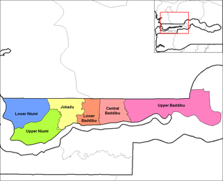
Central Baddibu is one of the six districts of the North Bank Division of the Gambia.

Kangsŏ is a Wards in Namp'o Special City, South P'yŏngan province, North Korea. The population is 100,000.

Sampov Meas District is a district in Pursat Province, Cambodia. The provincial capital of Pursat is located within the district.

Brzóski-Falki is a village in the administrative district of Gmina Wysokie Mazowieckie, within Wysokie Mazowieckie County, Podlaskie Voivodeship, in north-eastern Poland.
Khanikhola is a village development committee in Surkhet District in the Bheri Zone of mid-western Nepal. At the time of the 1991 Nepal census it had a population of 3127 people living in 512 individual households.

Święcieniec is a village in the administrative district of Gmina Słupno, within Płock County, Masovian Voivodeship, in east-central Poland. It lies approximately 15 kilometres (9 mi) east of Płock and 82 km (51 mi) north-west of Warsaw.
Zakrzew is a village in the administrative district of Gmina Jarocin, within Jarocin County, Greater Poland Voivodeship, in west-central Poland. It lies approximately 7 kilometres (4 mi) south of Jarocin and 69 km (43 mi) south-east of the regional capital Poznań.
Rybical is a village in the administrative district of Gmina Ryn, within Giżycko County, Warmian-Masurian Voivodeship, in northern Poland. It lies approximately 3 kilometres (2 mi) south of Ryn, 21 km (13 mi) south-west of Giżycko, and 70 km (43 mi) east of the regional capital Olsztyn.
Al Mahabishah District is a district of the Hajjah Governorate, Yemen. As of 2003, the district had a population of 50,865 inhabitants.

Ashburton Land District is a land district of Western Australia, located within the North-West Land Division.
Parks Glacier is a glacier draining southeastward from Weiss Amphitheater, a caldera in southern Mount Sidley, in the Executive Committee Range, Marie Byrd Land. Mapped by United States Geological Survey (USGS) on the Executive Committee Range Traverse of 1959. Named by Advisory Committee on Antarctic Names (US-ACAN) for Perry E. Parks, Jr., exploration geophysicist and assistant seismologist on the Marie Byrd Land Traverse, 1959-60.
Windell Land District is a land district of Western Australia and a subdivision of the North-West Land Division. It contains Newman, Paraburdoo and the former town of Wittenoom.
Forrest Land District is a land district of Western Australia and a subdivision of the North-West Land Division. It contains the towns of Port Hedland and South Hedland.
Dempster Land District is a land district of Western Australia, located within the Eucla Land Division.
Fitzroy Land District is a land district of Western Australia, located within the Kimberley Division of the state.
Koondra Land District is a land district of Western Australia and a subdivision of the North-West Land Division, located in the Pilbara region of the state.
Yowalga Land District is a land district of Western Australia, located within the Eastern Land Division in the Great Victoria Desert, north of the Nullarbor Plain. It spans roughly 26°50'S - 29°00'S in latitude and 125°00'E - 129°00'E in longitude.
Yamarna Land District is a land district of Western Australia, located within the Eastern Land Division in the Great Victoria Desert, north of the Nullarbor Plain. It spans roughly 26°50'S - 29°00'S in latitude and 123°30'E - 125°00'E in longitude.
Voskresensk is the name of several inhabited localities in Russia.
This page is based on this
Wikipedia article Text is available under the
CC BY-SA 4.0 license; additional terms may apply.
Images, videos and audio are available under their respective licenses.


