This article does not cite any sources . (March 2011) (Learn how and when to remove this template message) |
De Witt Western Australia | |
---|---|
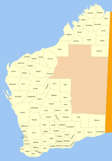
De Witt District is a land district (cadastral division) of Western Australia, located within the North-West Land Division.
The lands administrative divisions of Western Australia refer to subdivisions of the state of Western Australia for cadastral purposes, most of which have been in place since the 19th century. The state is divided up for this purpose into five land divisions, which in turn are subdivided into land districts, which correspond to counties in other Australian states. These districts are then subdivided further into numbered locations, as well as gazetted townsites. Together, they form part of the lands administrative divisions of Australia.
Western Australia is a state occupying the entire western third of Australia. It is bounded by the Indian Ocean to the north and west, and the Southern Ocean to the south, the Northern Territory to the north-east, and South Australia to the south-east. Western Australia is Australia's largest state, with a total land area of 2,529,875 square kilometres, and the second-largest country subdivision in the world, surpassed only by Russia's Sakha Republic. The state has about 2.6 million inhabitants – around 11 percent of the national total – of whom the vast majority live in the south-west corner, 79 per cent of the population living in the Perth area, leaving the remainder of the state sparsely populated.
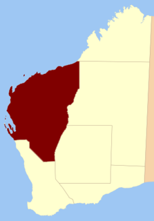
The North-West Land Division is one of five Land Divisions of Western Australia, part of the Cadastral divisions of Western Australia. It includes Carnarvon, Exmouth and Port Hedland. It is located in the Gascoyne region, the western Pilbara region, and part of the Mid West
Coordinates: 21°05′S116°20′E / 21.083°S 116.333°E
A geographic coordinate system is a coordinate system that enables every location on Earth to be specified by a set of numbers, letters or symbols. The coordinates are often chosen such that one of the numbers represents a vertical position and two or three of the numbers represent a horizontal position; alternatively, a geographic position may be expressed in a combined three-dimensional Cartesian vector. A common choice of coordinates is latitude, longitude and elevation. To specify a location on a plane requires a map projection.
This article about a location in Western Australia is a stub. You can help Wikipedia by expanding it. |
The geography of France consists of a terrain that is mostly flat plains or gently rolling hills in the north and west and mountainous in the south and the east. Metropolitan France has a total size of 551,695 km2 (213,011 sq mi). It is the third largest country in Europe after Russia and the Ukraine.
West Coast Division is an administrative division of Sabah, Malaysia. It occupies the northwest portion of Sabah. With an area of 7,588 square kilometres, it occupies 10.3% of Sabah's territory. It also has approximately 30% of Sabah's total population, with the main indigenous inhabitants comprising the Bajau, Bruneian Malay, Dusun, Illanun, Kadazan and Kedayan, as well with a significant numbers of Chinese. The division is divided into the districts of Ranau, Kota Belud, Tuaran, Penampang, Papar, and the state capital Kota Kinabalu. The main towns are as in the names of the districts, plus other towns including Putatan, Inanam, Telipok, Tamparuli, and Kinarut.
Rewa is a province of Fiji. With a land area of 272 square kilometers, it includes the capital city of Suva and is in two parts — one including part of Suva's hinterland to the west and a noncontiguous area to the east, separated from the rest of Rewa by Naitasiri Province. The province had a population of 108,016 at the 2017 census, making it Fiji's third most populous.
Landhagen is an Amt in the district of Vorpommern-Greifswald, in Mecklenburg-Vorpommern, Germany. The seat of the Amt is in Neuenkirchen.
Chrouy Sdau (ឃុំជ្រោយស្តៅ) is a khum (commune) of Thma Koul District in Battambang Province in north-western Cambodia.
Bình Gia is a rural district of Lạng Sơn Province in the Northeast region of Vietnam. As of 2003, the district had a population of 54,349. The district covers an area of 1,091 km². The district capital lies at Bình Gia.
Iavinomby-Vohibola is a town and commune in Madagascar. It belongs to the district of Fianarantsoa II, which is a part of Haute Matsiatra Region. The population of the commune was estimated to be approximately 10,000 in 2001 commune census.
Cetki is a village in the administrative district of Gmina Rypin, within Rypin County, Kuyavian-Pomeranian Voivodeship, in north-central Poland. It lies approximately 9 kilometres (6 mi) west of Rypin and 49 km (30 mi) east of Toruń.
Ignacewo is a village in the administrative district of Gmina Stawiski, within Kolno County, Podlaskie Voivodeship, in north-eastern Poland. It lies approximately 6 kilometres (4 mi) south-west of Stawiski, 14 km (9 mi) south-east of Kolno, and 77 km (48 mi) west of the regional capital Białystok.
Krasne Folwarczne is a village in the administrative district of Gmina Jasionówka, within Mońki County, Podlaskie Voivodeship, in north-eastern Poland. It lies approximately 9 kilometres (6 mi) south-east of Jasionówka, 21 km (13 mi) east of Mońki, and 25 km (16 mi) north of the regional capital Białystok.
Anielewo is a village in the administrative district of Gmina Kazimierz Biskupi, within Konin County, Greater Poland Voivodeship, in west-central Poland. It lies approximately 7 kilometres (4 mi) north-west of Kazimierz Biskupi, 18 km (11 mi) north-west of Konin, and 80 km (50 mi) east of the regional capital Poznań.
Żelkówko is a village in the administrative district of Gmina Kobylnica, within Słupsk County, Pomeranian Voivodeship, in northern Poland. It lies approximately 14 kilometres (9 mi) south-east of Kobylnica, 16 km (10 mi) south of Słupsk, and 101 km (63 mi) west of the regional capital Gdańsk.
Radfan District is a district of the Lahij Governorate, Yemen. As of 2003, the district had a population of 45,570 people.
Buningonia Land District is a land district of Western Australia, located within the Eastern Land Division on the Nullarbor Plain. It spans roughly 30°10'S - 32°00'S in latitude and 122°15'E - 124°00'E in longitude.
Yilgarn Land District is a land district of Western Australia, located within the Eastern Land Division.
Ularring Land District is a land district of Western Australia, located within the Eastern Land Division.
Murray Land District is a land district of Western Australia, located within the South-West Land Division on the state's west coast. It spans roughly 32°25'S - 32°56'S in latitude and 115°25'E - 116°30'E in longitude, and is located on the Indian Ocean coast, taking in the Shires of Murray and Waroona, the eastern part of the Serpentine-Jarrahdale and the western suburbs of Mandurah.
De Grey Land District is a land district of Western Australia and a subdivision of the North-West Land Division. It includes the Pilbara towns of Marble Bar and Nullagine and the former town of Goldsworthy.
Warramboo Land District is a land district of Western Australia, located within the North-West Land Division.
Peawah Land District is a land district of Western Australia, located within the North-West Land Division.