
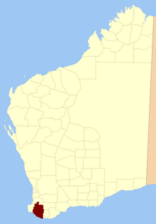
The South West region is one of the nine regions of Western Australia. It is so named because it is located in the south-west corner of Western Australia. The South West region has an area of 23,970 km², and a population of about 170,000 people, which is predicted to rise to 217,000 people by 2023.

The Division of Kalgoorlie was an Australian Electoral Division in the state of Western Australia, named after the city of Kalgoorlie. The Division was proclaimed in 1900 as one of the original 75 divisions to be contested at the first Federal election. In its final form, it covered most of the land area of Western Australia, with a size of 2,295,354 square kilometres (886,241 sq mi)—over 90 percent of the state's landmass. It included the Goldfields-Esperance, Gascoyne, Pilbara and Kimberley regions of Western Australia, in addition to the eastern and far northern parts of the Mid West region, and the town of Merredin. It was the largest single-member electorate by area in the world—almost a third of the continent.

Kimberley Land Division is one of five land divisions of Western Australia recognised in the Land Administration Act 1997. It occupies roughly the same area as the Kimberley region of the state.

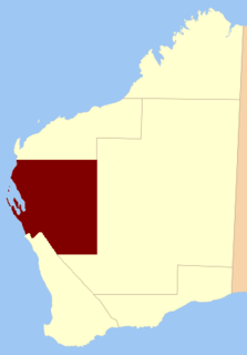
The South West Land Division is one of five Land Divisions of Western Australia, part of the cadastral divisions of Western Australia. It includes the cities of Perth, Albany, Bunbury, Geraldton and Mandurah. It also includes the regions of South West, Great Southern, Peel, most of the Wheatbelt, and the coastal areas of the Mid West.

The County of Wonnangatta is one of the 37 counties of Victoria which are part of the cadastral divisions of Australia, used for land titles. It includes the western parts of the Alpine National Park. The Wonnangatta River is located in the east of the county. Lake Eildon is at the northwestern edge. Mount Buller is on the northern edge.
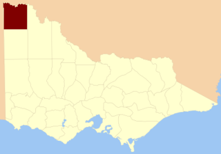
The County of Millewa is one of the 37 counties of Victoria which are part of the cadastral divisions of Australia, used for land titles. It is located to the south of the Murray River, at the north-western corner of Victoria, with the South Australian border to the west. This border was originally intended to be at the 141st meridian of longitude, but because of the South Australia-Victoria border dispute it is several miles to the west of it. The southern boundary of the county is at 35°S, and the eastern at 142°E. The name is also used for the region.

The Fortescue River is an ephemeral river in the Pilbara region of Western Australia. It is the third longest river in the state.
Nelson Land District is a land district of Western Australia, located within the South West Division on the state's south coast. It covers part of the state's Lower South West region and includes the townsites of Bridgetown, Manjimup, Pemberton, Northcliffe and Nannup as well as Point D'Entrecasteaux and, at its far southeastern corner, Walpole.

Grantham County was one of the 26 counties of Western Australia that were designated in 1829 as cadastral divisions. It approximately corresponds to parts of the Avon Land District and Williams Land District which form the basis for land titles in the area.
Murray County was one of the 26 counties of Western Australia that were designated in 1829 as cadastral divisions. It was named after George Murray, Secretary of State for War and the Colonies from 1828–1830, a personal friend of Lieutenant-Governor James Stirling.

Melbourne Land District is a land district of Western Australia, located within the South West Division.
Murray Land District is a land district of Western Australia, located within the South-West Land Division on the state's west coast. It spans roughly 32°25'S - 32°56'S in latitude and 115°25'E - 116°30'E in longitude, and is located on the Indian Ocean coast, taking in the Shires of Murray and Waroona, the eastern part of the Serpentine-Jarrahdale and the western suburbs of Mandurah.
Lyons Land District is a land district of Western Australia, located within the North-West Land Division.
Koondra Land District is a land district of Western Australia and a subdivision of the North-West Land Division, located in the Pilbara region of the state.
Gascoyne Land Division was a land division of Western Australia defined under the Land Regulations of 2 March 1887. It included almost all of the modern Gascoyne region of the State. In the Land Act 1898, it was renamed Western to avoid confusion with the Gascoyne Land District which had just been created by the Department of Lands and Surveys, and on 1 February 1907, section 26 of the Land Act Amendment Act 1906 merged it into North-West Land Division.
Wells Land District is a land district of Western Australia, located within the Eastern Land Division of the state. It spans roughly 24°00'S - 26°20'S in latitude and 121°40'E - 123°20'E in longitude. Its name honours Lawrence Allen Wells, an explorer of the area in 1896–1897.
Balwina Land District is a land district of Western Australia, located within the Eastern Land Division in the Great Sandy Desert. It spans roughly 19°30'S - 21°00'S in latitude and 126°25'E - 129°00'E in longitude.

Mount Augustus Station is a pastoral lease that operates as a cattle station in Western Australia.
Melangata Station is a pastoral lease that has operated as a goat transhipment location, as well as sheep station in Western Australia.
Worsley River is a river in the South West region of Western Australia. The river rises in the Darling Range 2 km south of the old timber town of Worsley then flows east and south discharging into the Collie River in Wellington Reservoir.


