Avon Land District

Last updated

Avon
Western Australia
Avon land district WA.png
Location in Western Australia
Lands administrative divisions around Avon:
Melbourne Ninghan Yilgarn
Swan Avon Jilbadji
Murray Williams Roe

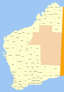
Avon Land District is a land district (cadastral division) of Western Australia, which is located within the South West Division. It covers areas of the Wheatbelt east and northeast of the capital, Perth. It is bounded on the west by Swan, to the northwest by Melbourne, to the north by Ninghan; on the east by Yilgarn and Jilbadji; on the southeast by Roe and on the south by Williams.

The lands administrative divisions of Western Australia refer to subdivisions of the state of Western Australia for cadastral purposes, most of which have been in place since the 19th century. The state is divided up for this purpose into five land divisions, which in turn are subdivided into land districts, which correspond to counties in other Australian states. These districts are then subdivided further into numbered locations, as well as gazetted townsites. Together, they form part of the lands administrative divisions of Australia.

Western Australia State in Australia

Western Australia is a state occupying the entire western third of Australia. It is bounded by the Indian Ocean to the north and west, and the Southern Ocean to the south, the Northern Territory to the north-east, and South Australia to the south-east. Western Australia is Australia's largest state, with a total land area of 2,529,875 square kilometres, and the second-largest country subdivision in the world, surpassed only by Russia's Sakha Republic. The state has about 2.6 million inhabitants – around 11 percent of the national total – of whom the vast majority live in the south-west corner, 79 per cent of the population living in the Perth area, leaving the remainder of the state sparsely populated.

Wheatbelt (Western Australia) region in Western Australia

The Wheatbelt is one of nine regions of Western Australia defined as administrative areas for the state's regional development, and a vernacular term for the area converted to agriculture during colonisation. It partially surrounds the Perth metropolitan area, extending north from Perth to the Mid West region, and east to the Goldfields-Esperance region. It is bordered to the south by the South West and Great Southern regions, and to the west by the Indian Ocean, the Perth metropolitan area, and the Peel region. Altogether, it has an area of 154,862 square kilometres (59,793 sq mi).

Coordinates: 31°36′56″S117°02′05″E / 31.61556°S 117.03472°E / -31.61556; 117.03472

Geographic coordinate system Coordinate system

A geographic coordinate system is a coordinate system that enables every location on Earth to be specified by a set of numbers, letters or symbols. The coordinates are often chosen such that one of the numbers represents a vertical position and two or three of the numbers represent a horizontal position; alternatively, a geographic position may be expressed in a combined three-dimensional Cartesian vector. A common choice of coordinates is latitude, longitude and elevation. To specify a location on a plane requires a map projection.


Related Research Articles

Płowce Village in Kuyavian-Pomeranian, Poland

Płowce is a village in the administrative district of Gmina Radziejów, within Radziejów County, Kuyavian-Pomeranian Voivodeship, in north-central Poland. It lies approximately 9 kilometres (6 mi) east of Radziejów and 47 km (29 mi) south of Toruń. The village has a population of 570.

Gołąbek, Kuyavian-Pomeranian Voivodeship Village in Kuyavian-Pomeranian, Poland

Gołąbek is a village in the administrative district of Gmina Cekcyn, within Tuchola County, Kuyavian-Pomeranian Voivodeship, in north-central Poland. It lies approximately 7 kilometres (4 mi) north-west of Cekcyn, 8 km (5 mi) east of Tuchola, and 56 km (35 mi) north of Bydgoszcz.

Pniski Village in Lublin, Poland

Pniski is a village in the administrative district of Gmina Sławatycze, within Biała Podlaska County, Lublin Voivodeship, in eastern Poland, close to the border with Belarus. It lies approximately 9 kilometres (6 mi) north-east of Sławatycze, 42 km (26 mi) south-east of Biała Podlaska, and 97 km (60 mi) north-east of the regional capital Lublin.

Skierwiny Village in Podlaskie, Poland

Skierwiny is a village in the administrative district of Gmina Drohiczyn, within Siemiatycze County, Podlaskie Voivodeship, in north-eastern Poland. It lies approximately 10 kilometres (6 mi) north of Drohiczyn, 18 km (11 mi) west of Siemiatycze, and 80 km (50 mi) south-west of the regional capital Białystok.

Mogilno Małe Village in Łódź, Poland

Mogilno Małe is a village in the administrative district of Gmina Dobroń, within Pabianice County, Łódź Voivodeship, in central Poland. It lies approximately 3 kilometres (2 mi) south-east of Dobroń, 9 km (6 mi) south-west of Pabianice, and 24 km (15 mi) south-west of the regional capital Łódź.

Niskowa Village in Lesser Poland, Poland

Niskowa is a village in the administrative district of Gmina Chełmiec, within Nowy Sącz County, Lesser Poland Voivodeship, in southern Poland. It lies approximately 3 kilometres (2 mi) south-west of Chełmiec, 5 km (3 mi) west of Nowy Sącz, and 71 km (44 mi) south-east of the regional capital Kraków.

Koźmice Wielkie Village in Lesser Poland, Poland

Koźmice Wielkie is a village in the administrative district of Gmina Wieliczka, within Wieliczka County, Lesser Poland Voivodeship, in southern Poland. It lies approximately 6 kilometres (4 mi) south-west of Wieliczka and 15 km (9 mi) south-east of the regional capital Kraków.

Zaborowice, Świętokrzyskie Voivodeship Village in Świętokrzyskie, Poland

Zaborowice is a village in the administrative district of Gmina Mniów, within Kielce County, Świętokrzyskie Voivodeship, in south-central Poland. It lies approximately 3 kilometres (2 mi) north of Mniów and 20 km (12 mi) north-west of the regional capital Kielce.

Cieplice, Podkarpackie Voivodeship Village in Subcarpathian, Poland

Cieplice is a village in the administrative district of Gmina Adamówka, within Przeworsk County, Subcarpathian Voivodeship, in south-eastern Poland. It lies approximately 6 kilometres (4 mi) west of Adamówka, 23 km (14 mi) north of Przeworsk, and 50 km (31 mi) north-east of the regional capital Rzeszów.

Humięcino-Koski is a village in the administrative district of Gmina Grudusk, within Ciechanów County, Masovian Voivodeship, in east-central Poland.

Leontyna, Masovian Voivodeship Village in Masovian, Poland

Leontyna is a village in the administrative district of Gmina Jakubów, within Mińsk County, Masovian Voivodeship, in east-central Poland. It lies approximately 5 kilometres (3 mi) west of Jakubów, 6 km (4 mi) north-east of Mińsk Mazowiecki, and 42 km (26 mi) east of Warsaw.

Hamer Młyn Village in Pomeranian, Poland

Hamer Młyn is a village in the administrative district of Gmina Lipnica, within Bytów County, Pomeranian Voivodeship, in northern Poland. It lies approximately 8 kilometres (5 mi) north-east of Lipnica, 11 km (7 mi) south of Bytów, and 83 km (52 mi) south-west of the regional capital Gdańsk.

Wolinia Village in Pomeranian, Poland

Wolinia is a village in the administrative district of Gmina Główczyce, within Słupsk County, Pomeranian Voivodeship, in northern Poland. It lies approximately 11 kilometres (7 mi) east of Główczyce, 37 km (23 mi) north-east of Słupsk, and 76 km (47 mi) west of the regional capital Gdańsk.

Strzebielinko Village in Pomeranian, Poland

Strzebielinko is a village in the administrative district of Gmina Gniewino, within Wejherowo County, Pomeranian Voivodeship, in northern Poland. It lies approximately 3 kilometres (2 mi) north-east of Gniewino, 20 km (12 mi) north-west of Wejherowo, and 56 km (35 mi) north-west of the regional capital Gdańsk.

Pomianowo, West Pomeranian Voivodeship Village in West Pomeranian, Poland

Pomianowo is a village in the administrative district of Gmina Białogard, within Białogard County, West Pomeranian Voivodeship, in north western Poland. It lies approximately 7 kilometres (4 mi) north-east of Białogard and 119 km (74 mi) north-east of the regional capital Szczecin.

Strumienno, West Pomeranian Voivodeship Village in West Pomeranian, Poland

Strumienno is a village in the administrative district of Gmina Bierzwnik, within Choszczno County, West Pomeranian Voivodeship, in north-western Poland. It lies approximately 4 kilometres (2 mi) east of Bierzwnik, 26 km (16 mi) south-east of Choszczno, and 87 km (54 mi) south-east of the regional capital Szczecin.

Hay Land District Cadastral in Western Australia

Not to be confused with the land district of the same name in New South Wales

Kojonup Land District Cadastral in Western Australia

Kojonup Land District is a land district of Western Australia, located within the South West Division.

Plantagenet Land District Cadastral in Western Australia

Plantagenet Land District is a land district of Western Australia, located within the South West Division.

Williams Land District Cadastral in Western Australia

Williams Land District is a land district of Western Australia, located within the South West Division.