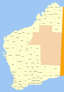
Yelina Land District

Last updated

Yelina
Western Australia
Western Australia land districts.png

Yelina Land District is a land district (cadastral division) of Western Australia, located within the Eastern Land Division.

The lands administrative divisions of Western Australia refer to subdivisions of the state of Western Australia for cadastral purposes, most of which have been in place since the 19th century. The state is divided up for this purpose into five land divisions, which in turn are subdivided into land districts, which correspond to counties in other Australian states. These districts are then subdivided further into numbered locations, as well as gazetted townsites. Together, they form part of the lands administrative divisions of Australia.

Western Australia State in Australia

Western Australia is a state occupying the entire western third of Australia. It is bounded by the Indian Ocean to the north and west, and the Southern Ocean to the south, the Northern Territory to the north-east, and South Australia to the south-east. Western Australia is Australia's largest state, with a total land area of 2,529,875 square kilometres, and the second-largest country subdivision in the world, surpassed only by Russia's Sakha Republic. The state has about 2.6 million inhabitants – around 11 percent of the national total – of whom the vast majority live in the south-west corner, 79 per cent of the population living in the Perth area, leaving the remainder of the state sparsely populated.
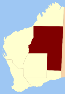
Eastern Land Division

Eastern Division is one of five land divisions of Western Australia, part of the cadastral divisions of Western Australia. Most of the land is desert, part of the Great Sandy Desert, Gibson Desert and Great Victoria Desert. It is located in the eastern parts of the Goldfields-Esperance region and the Pilbara region.

Coordinates: 26°20′S122°10′E / 26.333°S 122.167°E / -26.333; 122.167

Geographic coordinate system Coordinate system

A geographic coordinate system is a coordinate system that enables every location on Earth to be specified by a set of numbers, letters or symbols. The coordinates are often chosen such that one of the numbers represents a vertical position and two or three of the numbers represent a horizontal position; alternatively, a geographic position may be expressed in a combined three-dimensional Cartesian vector. A common choice of coordinates is latitude, longitude and elevation. To specify a location on a plane requires a map projection.


Related Research Articles

Division of Kalgoorlie abolished Australian federal electoral division

The Division of Kalgoorlie was an Australian Electoral Division in the state of Western Australia, named after the city of Kalgoorlie. The Division was proclaimed in 1900 as one of the original 75 divisions to be contested at the first Federal election. In its final form, it covered most of the land area of Western Australia, with a size of 2,295,354 square kilometres (886,241 sq mi)—over 90 percent of the state's landmass. It included the Goldfields-Esperance, Gascoyne, Pilbara and Kimberley regions of Western Australia, in addition to the eastern and far northern parts of the Mid West region, and the town of Merredin. It was the largest single-member electorate by area in the world—almost a third of the continent.

Kohat District District in Khyber Pakhtunkhwa Province, Pakistan

Kohat District is a district in Kohat Division of Khyber Pakhtunkhwa province in Pakistan, Kohat city is the capital of the district.

Hiệp Hòa District District in Bắc Giang, Vietnam

Hiệp Hòa is one of nine rural districts of Bắc Giang Province in the Northeast region of Vietnam. As of 2003 the district had a population of 210,980. The district covers an area of 201 km2. The district capital lies at Thắng. This is the home country of Trạng nguyên Đoàn Xuân Lôi of the Trần Dynasty, Tiến sĩ Trịnh Ngô Dụng of the Lê Dynasty, Đình nguyên Nguyễn Đình Tuân of the Nguyễn Dynasty.

A Lưới is a rural district of Thừa Thiên-Huế Province in the North Central Coast region of Vietnam. It is located west in the highly mountainous area of A Shau Valley bordering Laos. The population includes many Bru, Hoa and Tà Ôi people. As of 2003 the district had a population of 38,616. The district covers an area of 1,229 km² and its capital lies at A Lưới, a former French airfield, later used by the Americans in Operation Delaware and then by the North Vietnamese for courier flights.

Bulara Land District Cadastral in Western Australia

Bulara Land District is a land district of Western Australia, located within the Kimberley Division of the state.

Omalinde Land District Cadastral in Western Australia

Omalinde Land District is one of the land districts of Western Australia, located within the Kimberley Division of the state.

Luman Land District Cadastral in Western Australia

Luman Land District is a land district of Western Australia, located within the Kimberley Division of the state.

Nuleri Land District Cadastral in Western Australia

Nuleri Land District is a land district of Western Australia, located within the Eastern Land Division.

Ngalbain Land District Cadastral in Western Australia

Ngalbain Land District is a land district of Western Australia, located within the Eastern Land Division.

Nabberu Land District Cadastral in Western Australia

Nabberu Land District is a land district of Western Australia, located within the Eastern Land Division.

Plantagenet Land District Cadastral in Western Australia

Plantagenet Land District is a land district of Western Australia, located within the South West Division.

De Witt Land District Cadastral in Western Australia

De Witt District is a land district of Western Australia, located within the North-West Land Division.

Peawah Land District Cadastral in Western Australia

Peawah Land District is a land district of Western Australia, located within the North-West Land Division.

Nookawarra Land District Cadastral in Western Australia

Nookawarra Land District is a land district of Western Australia, located within the North-West Land Division.

Kyarra Land District Cadastral in Western Australia

Kyarra Land District is a land district of Western Australia, located within the North-West Land Division.

Gregory Land District Cadastral in Western Australia

Gregory Land District is a land district of Western Australia, located within the North-West Land Division.

Hardey Land District Cadastral in Western Australia

Hardey Land District is a land district of Western Australia, located within the North-West Land Division.

Dundas Land District Cadastral in Western Australia

Dundas Land District is a land district of Western Australia within the Eucla Land Division. It spans roughly 31°40'S - 32°40'S in latitude and 121°00'E - 122°15'E in longitude.

Wells Land District Cadastral in Western Australia

Wells Land District is a land district of Western Australia, located within the Eastern Land Division of the state. It spans roughly 24°00'S - 26°20'S in latitude and 121°40'E - 123°20'E in longitude. Its name honours Lawrence Allen Wells, an explorer of the area in 1896–1897.

Giles Land District Cadastral in Western Australia

Giles Land District is a land district of Western Australia, located within the Eastern and Eucla land divisions on the Nullarbor Plain. It spans roughly 29°00'S - 31°00'S in latitude and 123°30'E - 126°30'E in longitude.