| Weld Western Australia | |||||||||||||||
|---|---|---|---|---|---|---|---|---|---|---|---|---|---|---|---|
 Location in Western Australia | |||||||||||||||
| |||||||||||||||
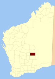
Weld Land District is one of the land districts of Western Australia, which is located within the Eastern Land Division in the north-eastern Goldfields region of the state.
| Weld Western Australia | |||||||||||||||
|---|---|---|---|---|---|---|---|---|---|---|---|---|---|---|---|
| Location in Western Australia | |||||||||||||||
| |||||||||||||||
Weld Land District is one of the land districts of Western Australia, which is located within the Eastern Land Division in the north-eastern Goldfields region of the state.
Its main centre of population is the town of Laverton, and it also includes the former towns of Mount Morgans, Mount Margaret, Burtville and Yundamindera to the west and the Mount Weld mine site to the south. It spans roughly 28°10'S - 29°00'S in latitude and 122°00'E - 123°30'E in longitude.
The district was created on 25 November 1901 and was defined in the Government Gazette:
Bounded by lines starting from a point situate 2 miles 10 chains West from Survey mark B82 at Brickey's Soak, and extending North to a point situate West from SUrvey mark HR (conjoined) 23; thence East to a point situate North from the summit of Mt Luck; thence South to a point situate East from the starting point; and thence West to the starting point.

The County of Ward is a county in the south-eastern corner of Queensland, Australia. The main urban area within the county is the city of the Gold Coast, and it also extends to include the southern parts of the West Moreton region centred on Beaudesert and Boonah.

Central Land Division was a land division of Western Australia defined under section 26 of the Land Act Amendment Act 1906, and existed from 1 February 1907 until 28 March 1917, when it became part of the Eastern Land Division under section 4 of the Land Act Amendment Act 1917. It was bounded by the Rabbit-proof fence in the west, and included Kalgoorlie. It comprised parts of the eastern Wheatbelt and the Goldfields-Esperance region.
Sussex Land District is a land district of Western Australia, located within the South-West Land Division on the state's west coast. It covers the south-western corner of the state and includes the townsites of Busselton, Margaret River and Augusta as well as Cape Naturaliste and Cape Leeuwin.

Buningonia Land District is a land district of Western Australia, located within the Eastern Land Division on the Nullarbor Plain. It spans roughly 30°10'S - 32°00'S in latitude and 122°15'E - 124°00'E in longitude.
Malcolm Land District is a land district of Western Australia, located within the Eastern Land Division in the northern Goldfields region of the state.
Hampton Land District is a land district of Western Australia, located within the Eastern Land Division in the Goldfields region of the state.
Roe Land District is a land district of Western Australia, located within the South-West Land Division in the eastern Wheatbelt region of the state.
Mundrabilla Land District is a land district of Western Australia, located within the Eucla Land Division on the Nullarbor Plain. It spans roughly 31°00'S - 32°00'S in latitude and 127°30'E - 129°00'E in longitude.
Fitzgerald Land District is a land district of Western Australia, located within the Eucla Land Division inland from Esperance. It spans roughly 32°35'S - 33°15'S in latitude and 121°00'E - 122°15'E in longitude.
Nuyts Land District is a land district of Western Australia, located within the Eastern and Eucla land divisions on the Nullarbor Plain. It spans roughly 31°00'S - 32°50'S in latitude and 124°00'E - 125°30'E in longitude.
Oldfield Land District is a land district of Western Australia partly within the Eucla and South-West divisions on the state's south coast. It spans roughly 33°15'S - 34°00'S in latitude and 119°45'E - 121°10'E in longitude.
Wells Land District is a land district of Western Australia, located within the Eastern Land Division of the state. It spans roughly 24°00'S - 26°20'S in latitude and 121°40'E - 123°20'E in longitude. Its name honours Lawrence Allen Wells, an explorer of the area in 1896–1897.
Giles Land District is a land district of Western Australia, located within the Eastern and Eucla land divisions on the Nullarbor Plain. It spans roughly 29°00'S - 31°00'S in latitude and 123°30'E - 126°30'E in longitude.
Delisser Land District is a land district of Western Australia, located within the Eastern and Eucla land divisions on the Nullarbor Plain. It spans roughly 29°00'S - 31°00'S in latitude and 126°30'E - 129°00'E in longitude. It was named after E.A. Delisser who surveyed and described the Nullarbor Plain in the 1860s.
Hann Land District is a land district of Western Australia, located within the Eastern Land Division of the state. It spans roughly 24°00'S - 25°40'S in latitude and 120°00'E - 121°40'E in longitude, east of the rabbit-proof fence. Part of the Canning Stock Route passes through the south-east of the district. It is named in honour of explorer Frank Hann.
Tugaila Land District is a land district of Western Australia, located within the Eastern Land Division in the Gibson Desert. It spans roughly 24°00'S - 26°50'S in latitude and 123°20'E - 125°50'E in longitude.
Milyuga Land District is a land district of Western Australia, located within the Eastern Land Division in the Gibson Desert. It spans roughly 24°00'S - 26°50'S in latitude and 125°50'E - 129°00'E in longitude, and includes the town of Warburton and the Giles Weather Station.
Yowalga Land District is a land district of Western Australia, located within the Eastern Land Division in the Great Victoria Desert, north of the Nullarbor Plain. It spans roughly 26°50'S - 29°00'S in latitude and 125°00'E - 129°00'E in longitude.
Yamarna Land District is a land district of Western Australia, located within the Eastern Land Division in the Great Victoria Desert, north of the Nullarbor Plain. It spans roughly 26°50'S - 29°00'S in latitude and 123°30'E - 125°00'E in longitude.
Balwina Land District is a land district of Western Australia, located within the Eastern Land Division in the Great Sandy Desert. It spans roughly 19°30'S - 21°00'S in latitude and 126°25'E - 129°00'E in longitude.
"Weld (Land) District (per 11615/01)". Western Australia Government Gazette. 25 November 1901. p. 1901:4741.
28°39′55″S122°25′05″E / 28.66528°S 122.41806°E
| | This article about a location in Western Australia is a stub. You can help Wikipedia by expanding it. |