
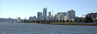
Perth is the capital and largest city of Western Australia. It is the fourth most populous city in Australia and Oceania, with a population of 2.2 million within Greater Perth. It is part of the South West Land Division of Western Australia, with the majority of Perth's metropolitan area on the Swan Coastal Plain between the Indian Ocean and the Darling Scarp. The city has expanded outward from the original British settlements on the Swan River, upon which its central business district and port of Fremantle are situated.

The Swan River is a major river in the southwest of Western Australia. The river runs through the metropolitan area of Perth, Western Australia's capital and largest city.
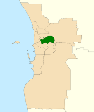
The Division of Swan is an Australian electoral division located in Western Australia.

The Division of Perth is an Australian electoral division in the state of Western Australia. It is named after Perth, the capital city of Western Australia, where the Division is located.
Perth Water is a section of the Swan River on the southern edge of the central business district of Perth, Western Australia. It is between the Causeway to the east, and Narrows Bridge to the west – a large wide but shallow section of river, and the northern edge of the suburb South Perth. It is considered a landmark of the City of Perth.
Embleton is a suburb of Perth, the capital city of Western Australia, located 7 kilometres (4.3 mi) north-east of the central business district, between the suburbs of Morley and Bayswater. Its local government area is the City of Bayswater.

The Canning River is a major tributary of the Swan River in the South West Land Division of Western Australia. It is home to much wildlife including dolphins, pelicans, swans and many other bird species.

Lake Monger is a large urban wetland on the Swan Coastal Plain in suburban Perth, Western Australia nestled between the suburbs of Leederville, Wembley and Glendalough.
Perth is the capital city of Western Australia. It was established by Britain as the Swan River Colony in 1829. The area had been explored by Europeans as early as 1697, and occupied by the Indigenous Whadjuk Noongar people for millennia.

Baskerville is an outer northeastern rural suburb of Perth, Western Australia, in the Swan Valley region, 31 km from Perth's central business district via Midland and Great Northern Highway. Nearly all of it is under cultivation with viticulture being the main economic activity, and several well-established Swan Valley wineries are based here. Its local government area is the City of Swan.
Transport in Perth, Western Australia, is served by various means, among them an extensive highway / freeway network and a substantial system of commuter rail lines and bus routes. Public transport is managed by the Transperth agency.
The electoral district of Canning was an electorate in the state of Western Australia. The electorate, which was named for the Canning River which ran through it, was first contested at the 1897 election, but was abolished prior to the 1901 election, with most of its territory transferred to the new seat of South Perth. However, for the 1904 election, South Perth was abolished and Canning re-created. Canning was abolished for a second time in the 1988 redistribution.
Wellington Land District is a land district of Western Australia, located within the South-West Land Division on the state's west coast. It spans roughly 32°56'S - 33°40'S in latitude and 115°25'E - 116°50'E in longitude.
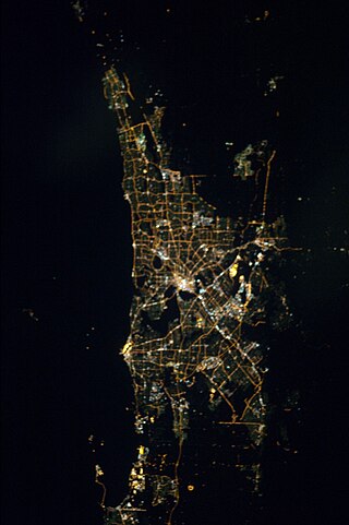
The Perth metropolitan region or the Perth metropolitan area is the administrative area and geographical extent of the Western Australian capital city of Perth and its conurbation.

The Perth Wetlands, also known as the Perth Great Lakes or the Great Lakes District, was a collection of fresh-water wetlands, swamps and lakes located on the Swan Coastal Plain north of the city of Perth in Western Australia. Over a period of 80 years from the first British settlement in Western Australia in 1829 most of the wetlands were reclaimed for use as housing, parks and market gardens.

Fremantle is a Western Australian suburb located in Perth at the mouth of the Swan River, and is situated 18 kilometres (11 mi) from the Perth central business district. One of the original settlements of the Swan River Colony established in 1829 is within the area known today as this suburb.

Morley Drive is a major east–west road in the inner northern suburbs of Perth, Western Australia, connecting the residential areas of Balcatta, Osborne Park, Tuart Hill, Nollamara, Yokine, Dianella, and Morley with major north-south arterial roads including Wanneroo Road, Alexander Drive, and Tonkin Highway.
The 1829 town plan of Perth, Western Australia was an elongated grid pattern that reflected the city planning principles of the day, and was typical of colonial Williamsburg (1699) and the Edinburgh "new town" (1768). The plan expressed enlightenment principles of the town as the seat of civic power within a large and productive agricultural hinterland. Contrary to these ideals, Perth became the commercial center of the colony, and later, metropolitan region with a layout that has remained relatively unchanged to the present day.
Pier Street is a street in the central business district of Perth, Western Australia. It runs from St Georges Terrace to Wellington Street, continuing immediately north of the railway until Brisbane Street very close to where Brisbane Street meets Bulwer Street.
Charles Street is a major road in the inner northern suburbs of Perth, Western Australia. It runs from Newcastle Street and extends up to London Street, providing a connection between Mitchell Freeway and Wanneroo Road. It is the southern section of part of State Route 60, which continues north along Wanneroo Road.

