Roe Western Australia | |||||||||||||||
---|---|---|---|---|---|---|---|---|---|---|---|---|---|---|---|
|
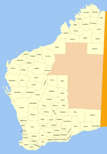
Roe Land District is a land district (cadastral division) of Western Australia, located within the South-West Land Division in the eastern Wheatbelt region of the state.
The lands administrative divisions of Western Australia refer to subdivisions of the state of Western Australia for cadastral purposes, most of which have been in place since the 19th century. The state is divided up for this purpose into five land divisions, which in turn are subdivided into land districts, which correspond to counties in other Australian states. These districts are then subdivided further into numbered locations, as well as gazetted townsites. Together, they form part of the lands administrative divisions of Australia.
Western Australia is a state occupying the entire western third of Australia. It is bounded by the Indian Ocean to the north and west, and the Southern Ocean to the south, the Northern Territory to the north-east, and South Australia to the south-east. Western Australia is Australia's largest state, with a total land area of 2,529,875 square kilometres, and the second-largest country subdivision in the world, surpassed only by Russia's Sakha Republic. The state has about 2.6 million inhabitants – around 11 percent of the national total – of whom the vast majority live in the south-west corner, 79 per cent of the population living in the Perth area, leaving the remainder of the state sparsely populated.
The Wheatbelt is one of nine regions of Western Australia defined as administrative areas for the state's regional development, and a vernacular term for the area converted to agriculture during colonisation. It partially surrounds the Perth metropolitan area, extending north from Perth to the Mid West region, and east to the Goldfields-Esperance region. It is bordered to the south by the South West and Great Southern regions, and to the west by the Indian Ocean, the Perth metropolitan area, and the Peel region. Altogether, it has an area of 154,862 square kilometres (59,793 sq mi).
The district was created on 9 August 1899, named in honour of the first Surveyor General of Western Australia, John Septimus Roe, and was defined in the Government Gazette: [1]
The Surveyor General of Western Australia is the person nominally responsible for government surveying in Western Australia.
John Septimus Roe was the first Surveyor-General of Western Australia. He was a renowned explorer, and a Member of Western Australia's legislative and executive councils for nearly 40 years.
“ | Bounded on the North by the South boundary of the Yilgarn Goldfield, being a West line from a point situate 90 miles South from survey mark H. 26 on Koorarawalyee Granit Rock; on the West by a prolongation South of the West boundary of said Goldfield (said boundary being a North and South line through a point situate 10 miles West of the Cairn on Yorkrakine Granite Rock); on the South by an East line from a point situate East from the North-East corner of Kojonup Location 268, and on the East by a North line through Mount Madden to the latitude of Mount Ridley (33°17'38"S), an East line towards Mount Ridley, and a North line towards aforesaid survey mark H. 26 and Koorarawalyee Granite Rock. | ” |
The Shire of Lake Grace is a local government area in the Eastern Wheatbelt region of Western Australia, about 350 kilometres (217 mi) ESE of the state capital, Perth. The Shire has a land area of 10,379 square kilometres (4,007 sq mi) and its seat of government is the town of Lake Grace.
Holt Rock is a small town in the Wheatbelt region of Western Australia. It is situated between the towns of Hyden and Varley close to the edge of Lake Hurlstone.
The Shire of Kulin is a local government area in the Eastern Wheatbelt region of Western Australia, about 300 kilometres (186 mi) ESE of the state capital, Perth. The Shire's land area of 4,714 square kilometres (1,820 sq mi) forms a narrow east-west band, located between the Shire of Kondinin to the north and the Shire of Lake Grace to the south. Its seat of government is the town of Kulin. The local economy is based on agriculture - predominantly cereal grains and sheep.
Lake Grace is a town in the Eastern Wheatbelt region of Western Australia, 345 kilometres (214 mi) from Perth along State Route 107 between Wagin and Ravensthorpe. It is the main town in the Shire of Lake Grace. At the 2016 census, Lake Grace had a population of 507.
The town of Hyden is located 292 kilometres (181 mi) east-southeast of Perth, Western Australia in the Shire of Kondinin. Hyden is home to Wave Rock, Mulka's Cave and Hippos Yawn, all popular local tourist attractions.
Kulin is a town in the Eastern Wheatbelt region of Western Australia, approximately 280 km from Perth. It is the main town in the Shire of Kulin.
Roe is an electoral district of the Legislative Assembly of Western Australia. It takes in rural areas in the south of the state. Roe was re-created for the 2017 state election, having previously been in existence from 1950 to 1983 and from 1989 to 2008. It has a notional 16.7-point majority for the National Party against the Liberal Party, based on the results of the 2013 state election.
Harrismith is a small town in the Wheatbelt region of Western Australia, approximately 260 kilometres (162 mi) south-east of Perth between the towns of Wickepin and Kulin.
Tincurrin is a small town in the Wheatbelt region of Western Australia, 250 kilometres (155 mi) south-east of Perth and within the Shire of Wickepin.
The Shire of Kondinin is a local government area in the Eastern Wheatbelt region of Western Australia, about 300 kilometres (186 mi) east of the state capital, Perth. The Shire's land area of 7,376 square kilometres (2,848 sq mi) forms a narrow east-west band, located between the Shire of Narembeen to the north and the Shire of Kulin to the south. Its seat of government is the town of Kondinin.
Kondinin is a town located in the eastern Wheatbelt region of Western Australia, 279 kilometres (173 mi) east of the state capital, Perth via the Brookton Highway and State Route 40 between Corrigin and Hyden. It is the main town in the Shire of Kondinin. At the 2006 census, Kondinin had a population of 311.
The City of Armadale is a local government area in the south-eastern suburbs of the Western Australian capital city of Perth, about 28 kilometres (17.4 mi) southeast of Perth's central business district. The City covers an area of 560 square kilometres (216 sq mi), much of which is state forest rising into the Darling Scarp to the east, and had a population of almost 80,000 as at the 2016 Census.
The Shire of Narembeen is a local government area in the Eastern Wheatbelt region of Western Australia, about 300 kilometres (186 mi) east of the state capital, Perth, and between the shires of Merredin to the north, and Kondinin to the south. The Shire has a land area of 3,833 square kilometres (1,480 sq mi) and its seat of government is the town of Narembeen.
The Shire of Sandstone is a local government area in the eastern Mid West region of Western Australia, about 740 kilometres (460 mi) northeast of the state capital, Perth. The Shire covers an area of 32,882 square kilometres (12,696 sq mi), and its seat of government is the town of Sandstone.
The Roe state by-election, 1967 was a by-election held on 2 September 1967 for the Western Australian Legislative Assembly seat of Roe in the southeastern agricultural part of the state.
Windell Land District is a land district of Western Australia and a subdivision of the North-West Land Division. It contains Newman, Paraburdoo and the former town of Wittenoom.
Nuyts Land District is a land district of Western Australia, located within the Eastern and Eucla land divisions on the Nullarbor Plain. It spans roughly 31°00'S - 32°50'S in latitude and 124°00'E - 125°30'E in longitude.
Highways and main roads in the Wheatbelt region of Western Australia form the basis of a road network, which is primarily used by the mining, agriculture, and tourism industries. Main Roads Western Australia maintains and controls these major roads, with offices based in Northam and Narrogin. There are six main highways through the Wheatbelt that radiate out from Perth:
Jilakin Rock is a granite rock formation located approximately 15 km (9.3 mi) east of east of Kulin and approximately 25 km (16 mi) south of Kondinin in the central Wheatbelt region of Western Australia. It overlooks Jilakin Lake and is a prominent feature in the area, rising out of the surrounding flat plains.
Yeerakine Rock is a granite rock formation located approximately 12 km (7.5 mi) south of Kondinin and approximately 20 km (12 mi) north west of Kulin in the central Wheatbelt region of Western Australia.
Coordinates: 32°35′S119°00′E / 32.583°S 119.000°E
A geographic coordinate system is a coordinate system that enables every location on Earth to be specified by a set of numbers, letters or symbols. The coordinates are often chosen such that one of the numbers represents a vertical position and two or three of the numbers represent a horizontal position; alternatively, a geographic position may be expressed in a combined three-dimensional Cartesian vector. A common choice of coordinates is latitude, longitude and elevation. To specify a location on a plane requires a map projection.
This article about a location in Western Australia is a stub. You can help Wikipedia by expanding it. |